|
This loop hike can be walked in either direction, but if it is being done as a day hike I recommend you walk around the loop in a clockwise direction. That way you will have a better chance to see Gilpin Lake before the usual afternoon clouds roll in; Gilpin Lake is located in an extraordinarily scenic area.
In the first few miles the trail passes by several clearings in the forest where a surprisingly large number of tall trees have been uprooted and blown over. The fallen trees are the result of the Routt Divide Blowdown, a freak windstorm in 1997 that still has scientists scratching their heads in amazement. It happened in the early morning hours of October 25. A blizzard had been raging along the entire Front Range for the previous two days, and there was heavy snowfall from Wyoming to New Mexico. The mountain tops were experiencing temperatures well below zero with wind chill temperatures as low as -60 degrees F. Then between 4:00 and 10:00 a.m. a high-altitude wind stream with a velocity estimated to be in excess of 120 miles per hour dipped down to the western side of the Continental Divide and hit the ground with devastating force. Before the wind had abated some four million trees were down along a band 4 miles wide and 30 miles long. The Routt Divide Blowdown of 1997 was the largest recorded blowdown that has ever occurred in the Rocky Mountains.
From the trailhead the path climbs gently upward through an aspen forest for 0.2 mile to a junction where you must bear left toward Gilpin Lake. The trail on the right is the Gold Creek Trail that you will be following on the return portion of the hike. From the Gold Creek Trail junction the path continues a long, gentle climb along the north side of Gilpin Creek. You will seldom be close enough to the creek to see the water, but the sounds of the cascading stream will remind you of its presence.
1.2 miles from the trailhead you will pass the Mica Basin Trail on your left, and from that point the path follows closer to the shore of Gilpin Creek. Finally, about an hour’s walk beyond the junction with the Mica Basin Trail, the path comes to a relatively flat area where Gilpin Creek flows through a grassy meadow. Here the trail turns southeast, crosses the creek, and begins climbing in earnest for the last 0.8 mile to Gilpin Lake.
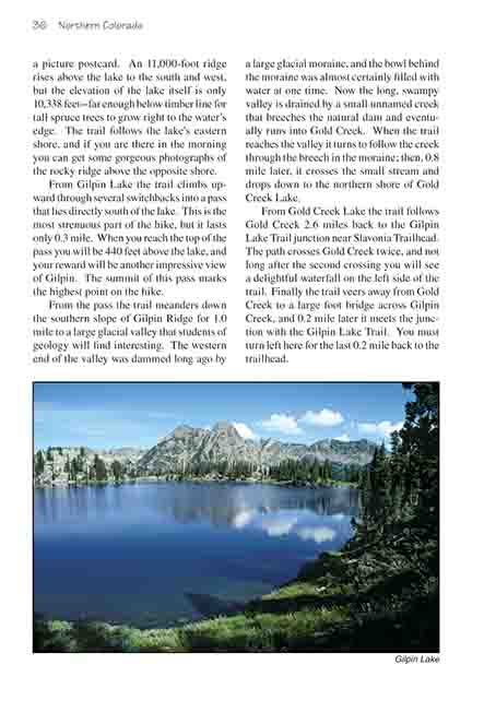
Gilpin Lake looks like it was taken from a picture postcard. An 11,000-foot ridge rises above the lake to the south and west, but the elevation of the lake itself is only 10,338 feet-far enough below timber line for tall spruce trees to grow right to the water’s edge. The trail follows the lake’s eastern shore, and if you are there in the morning you can get some gorgeous photographs of the rocky ridge above the opposite shore.
From Gilpin Lake the trail climbs upward through several switchbacks into a pass that lies directly south of the lake. This is the most strenuous part of the hike, but it lasts only 0.3 mile. When you reach the top of the pass you will be 440 feet above the lake, and your reward will be another impressive view of Gilpin. The summit of this pass marks the highest point on the hike.
From the pass the trail meanders down the southern slope of Gilpin Ridge for 1.0 mile to a large glacial valley that students of geology will find interesting. The western end of the valley was dammed long ago by a large glacial moraine, and the bowl behind the moraine was almost certainly filled with water at one time. Now the long, swampy valley is drained by a small unnamed creek that breeches the natural dam and eventually runs into Gold Creek. When the trail reaches the valley it turns to follow the creek through the breech in the moraine; then, 0.8 mile later, it crosses the small stream and drops down to the northern shore of Gold Creek Lake.
From Gold Creek Lake the trail follows Gold Creek 2.6 miles back to the Gilpin Lake Trail junction near Slavonia Trailhead. The path crosses Gold Creek twice, and not long after the second crossing you will see a delightful waterfall on the left side of the trail. Finally the trail veers away from Gold Creek to a large foot bridge across Gilpin Creek, and 0.2 mile later it meets the junction with the Gilpin Lake Trail. You must turn left here for the last 0.2 mile back to the trailhead. |