This hike offers a relatively easy three-day tour of six
lakes in the Eagles Nest Wilderness Area. Two of the lakes, Upper Cataract
and Mirror, lie just below the north side of Eagles Nest Peak, the rugged
13,397-foot peak for which the wilderness was named. The Eagles Nest is but
one of six local summits that extend along the jagged summit ridge for
almost a mile, giving the crest the appearance of a serrated knife blade.
Further south along the ridge, 1.2 miles from the Eagles Nest, is Mount
Powell, the highest peak in the Gore Range. Mount Powell was named after
Major John Wesley Powell, who in 1868 became the first known man to reach
its summit.
The Gore Range is remarkably free of the mining activity
that has despoiled many of Colorado’s other mountain ranges over the past
150 years. Nevertheless its timber and water resources have long been
coveted by special interests, and local conservation groups faced a daunting
political battle in the mid-1970s when they fought to have the Gore Range
protected from development. In the end the Forest Service’s plan to sell
logging concessions was thwarted, the Denver Water Department was forced to
cancel its plans to divert water from the range east to Denver, and the U.S.
Department of Transportation had to redesign and reroute I-70 south around
the southern tip of the Gore Range. The citizens prevailed, and the Eagles
Nest Wilderness Area was created in 1976.
Day 1 (5.8 miles)
From Surprise Trailhead the trail winds steadily upward
through an elevation gain of 1,300 feet before arriving, 2.6 miles later, at
the junction with the Gore Trail. The forest is surprisingly open near the
bottom of the trail, with large open meadows and scattered groves of aspen.
But after walking a mile or so you will begin to see fewer aspen and more
spruce. There are an unusual number of fallen trees in the upper conifer
forest, but the Forest Service has done a good job of cutting them away from
the trail itself.
When you reach the Gore Trail turn right, and within 0.2
miles you will see Surprise Lake. Surprise Lake is small-only about 200
yards across-but because it is so close to the trailhead it is a popular
destination for day hikers. You may even see a few tents there. 0.6 mile
beyond Surprise Lake there is another signed junction, where you must leave
the Gore Trail and bear left towards Upper Cataract Lake.
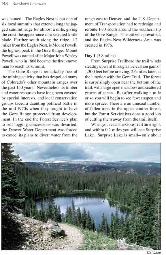
The trail continues upward through dense forest for 1.7
miles after leaving the Gore Trail before coming to an open area with
welcome views of the mountain peaks above. You will also be able to see Cat
Lake from here, 250 feet below the trail. 0.2 mile later you should see a
sign marking the spur trail to Cataract Lake. Turn left and within a few
minutes you will be on the north shore of the lake.
There are a number of nice campsites around Cataract
Lake, the fishing is reasonably good, and the views of Eagles Nest Peak are
marvelous. All things considered it is a great place to spend a night. Upper
Cataract is very popular, however, and during the summer it is often
crowded. If you crave more solitude there are also some nice campsites at
Cat Lake, just north of the main trail.
Day 2 (7.7 miles)
Before leaving Upper Cataract Lake I suggest you stash
your packs and walk to Mirror Lake, 1.4 miles further along the main trail.
Mirror is also a very pretty lake with a nice view of the Eagles Nest from
its western shore. The trail to the lake is a pleasant walk through open
forest with about 300 feet of elevation gain. There are also some nice
places to camp on the northwest side of the lake if you want to extend your
trip.
After you have seen Mirror Lake you will have to retrieve
your packs at Cataract and retrace your steps for 2.2 miles back to the Gore
Trail. When you reach the junction turn left and proceed in a westerly
direction. The trail descends gradually for 1.4 miles before reaching the
signed spur trail to Tipperary Lake. Tipperary is 200 feet below the main
trail, and the descent is quite steep. There are a few campsites at the lake
but, unfortunately, Tipperary is a favorite among horseback riders, and
there is a great deal of horse manure around the campsites. I suggest you
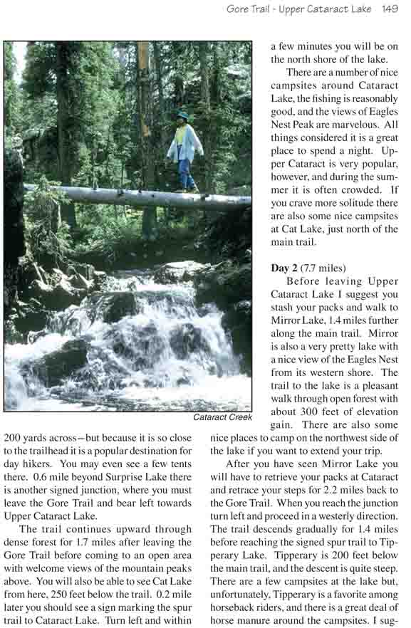
continue on for another 0.7 mile to Cataract Creek. Cataract Creek is a very
scenic spot along the Gore Trail to stop for the night, and there is a great
camping spot just before the trail crosses the creek.
Day 3 (5.8 miles)
0.8 mile after leaving Cataract Creek you will come to
another trail junction, where the trail to Lower Cataract Lake leaves the
Gore Trail. You will have to bear right here when you return to Lower
Cataract, but first take off your packs and continue along the Gore Trail
for another 0.9 mile to the Eaglesmere Lakes. These lakes are very popular
with day hikers. They aren’t as pretty as Mirror or Upper Cataract, but as
long as you are so close you should take the time to see them. About 20
minutes from the junction you will come to a swampy area where a small sign
points the way up a shallow drainage that leads to the lakes. You will come
to the first lake about 200 feet from the main trail, and the second lake
will appear soon afterward. The second is the nicer of the two.
After you recover your pack at the junction it is another
2.9 miles down to the Eaglesmere Trailhead on the north side of Lower
Cataract Lake. You will notice that this section of trail is in much better
condition than the Gore Trail. As you descend you will begin to see more
lodgepole pine and aspen, and finally large open areas with fine views over
Lower Cataract Lake. Notice the waterfall above the south end of the lake.
This is Cataract Falls, after which the creek and the lake were named. Also,
one cannot help but notice the unusual abundance of mariposa lilies along
this part of the trail. These are the stunning cup-shaped flowers on tall
slender stems with three white petals surrounding a yellow interior.
When you reach the Eaglesmere Trailhead it is an easy 0.3
mile walk down the road to the lower Surprise Trailhead where the hike
began.