Grays and Torreys Peaks are the two highest points on the
Continental Divide. Torreys was named after John Torrey, an early
nineteenth-century botanist who is best remembered for his work in
classifying North American flora. Grays Peak was named in recognition of Asa
Gray, also a well known botanist in the mid 1800s, whose research on
variations in plant species provided important evidence in support of
Charles Darwin’s Theory of Evolution.
The Grays Peak Trail has recently been designated as a
National Recreational Trail, and it is one of the best maintained of any of
the fourteener trails. The trail approaches the peak through a gorgeous
glacial valley with Kelso Mountain (13,164 ft.) on one side and Mount
Edwards (13,850 ft.) on the other. The valley ends at the foot of the
Continental Divide below the saddle connecting Grays Peak with Torreys.
Asa Gray and John Torrey were close friends and
associates; hence it is fitting that Grays and Torreys Peaks are only
0.7 mile apart with an easy connecting ridge between them. The round
trip distance up Grays, the higher peak, is 8.0 miles, but adding
Torreys to the itinerary lengthens the hike by only one extra mile and
600 feet of additional elevation gain. Consequently, they are often
climbed in combination.
The trail begins by crossing the creek at the bottom
of Stevens Gulch on a steel bridge. It then parallels the creek as it
makes a long, gradual climb along the west side of the valley. Finally,
after a distance of 1.4 miles and an elevation gain of 800 feet the
trail enters the high alpine plateau that forms the headwaters of
Stevens Gulch. This beautiful alpine meadow is devoid of trees but
filled with low-lying thickets of Scouler willows; it also offers a
magnificent view of Grays and Torreys Peaks.
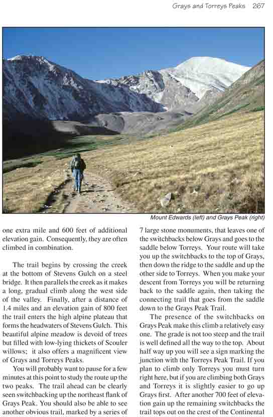
You will probably want to pause for a few minutes at
this point to study the route up the two peaks. The trail ahead can be
clearly seen switchbacking up the northeast flank of Grays Peak. You should also be
able to see another obvious trail, marked by a series of 7 large stone
monuments, that leaves one of the switchbacks below Grays and goes to the
saddle below Torreys. Your route will take you up the switchbacks to the top
of Grays, then down the ridge to the saddle and up the other side to
Torreys. When you make your descent from Torreys you will be returning back
to the saddle again, then taking the connecting trail that goes from the
saddle down to the Grays Peak Trail.
The presence of the switchbacks on Grays Peak make this
climb a relatively easy one. The grade is not too steep and the trail is
well defined all the way to the top. About half way up you will see a sign
marking the junction with the Torreys Peak Trail. If you plan to climb only
Torreys you must turn right here, but if you are climbing both Grays and
Torreys it is slightly easier to go up Grays first. After another 700 feet
of elevation gain up the remaining switchbacks the trail tops out on the
crest of the Continental Divide. Turn right here and continue west for
another 200 yards to the summit.
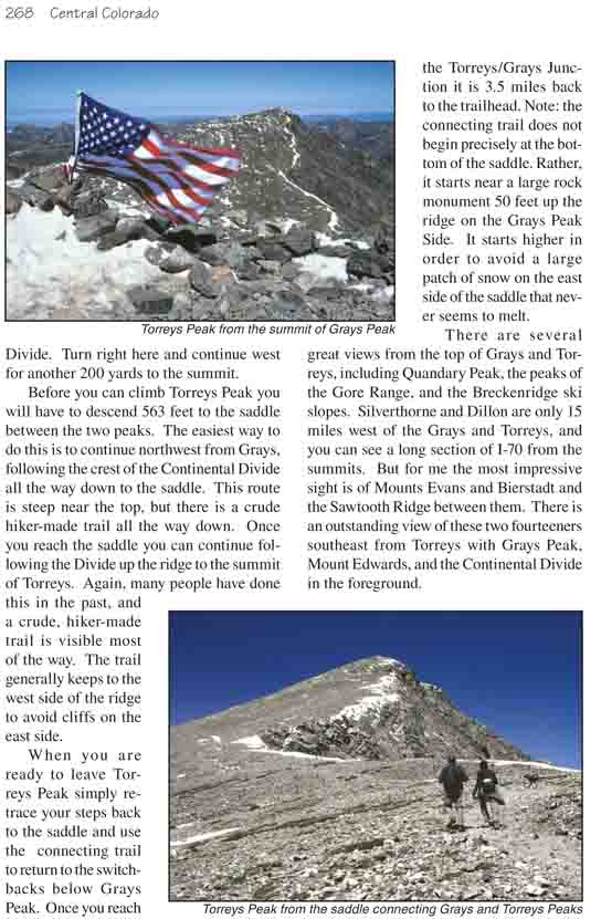
Before you can climb Torreys Peak you will have to
descend 563 feet to the saddle between the two peaks. The easiest way to do
this is to continue northwest from Grays, following the crest of the
Continental Divide all the way down to the saddle. This route is steep near
the top, but there is a crude hiker-made trail all the way down. Once you
reach the saddle you can continue following the Divide up the ridge to the
summit of Torreys. Again, many people have done this in the past, and a
crude, hiker-made trail is visible most of the way. The trail generally
keeps to the west side of the ridge to avoid cliffs on the east side.
When you are ready to leave Torreys Peak simply retrace
your steps back to the saddle and use the connecting trail to return to the
switchbacks below Grays Peak. Once you reach the Torreys/Grays Junction it
is 3.5 miles back to the trailhead. Note: the connecting trail does not
begin precisely at the bottom of the saddle. Rather, it starts near a large
rock monument 50 feet up the ridge on the Grays Peak Side. It starts higher
in order to avoid a large patch of snow on the east side of the saddle that
never seems to melt.
There are several great views from the top of Grays and
Torreys, including Quandary Peak, the peaks of the Gore Range, and the
Breckenridge ski slopes. Silverthorne and Dillon are only 15 miles west of
the Grays and Torreys, and you can see a long section of I-70 from the
summits. But for me the most impressive sight is of Mounts Evans and
Bierstadt and the Sawtooth Ridge between them. There is an outstanding view
of these two fourteeners southeast from Torreys with Grays Peak, Mount
Edwards, and the Continental Divide in the foreground.