There are two commonly used trails to the summit of
Handies Peak: one goes up through American Basin on the west side of the
mountain, and the other approaches the peak from the east through Grizzly
Gulch. Of these two alternatives the trail through American Basin is the
most popular, simply because it is shorter. It is only 2.1 miles from the
American Basin Trailhead to the summit, and the elevation gain is only 2,450
feet. The round trip hike from American Basin to the summit of Handies Peak
can easily be done in 4 or 5 hours.
But in my opinion Grizzly Gulch is one of the most
striking glacial valleys in the San Juans, and it would be a shame to miss
it. I suggest you climb Handies from the American Basin Trailhead but make
your descent down the Grizzly Gulch Trail to experience the joy of a
downhill stroll through an incredibly beautiful alpine valley.
To do this one-way hike you should ideally have an extra
car to leave at the exit trailhead, but there are several alternatives: One:
since the distance between trailheads is only 4.5 miles it is quite feasible
to do the shuttle with a mountain bike. Two: Since the Grizzly Gulch
Trailhead is located on the popular Alpine Loop Road there is a lot of jeep
traffic, and it isn’t too difficult to hitch a ride as far as the turnoff to
American Basin. From there it is only a 0.9 mile walk up the American Basin
Road to the beginning trailhead. Three: If you are unable to get a ride it
is a 4.5-mile road walk from the Grizzly Gulch Trailhead back to the
American Basin Trailhead.
A well trodden path follows the bottom of the
drainage from the trailhead up into the beautiful American Basin. The
trail bears south for 0.8 mile and then turns east toward a ridge on the
south side of the peak. After climbing 500 feet up the side of the ridge
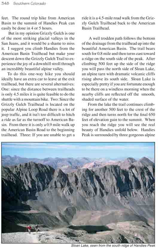
you will pass the north side of Sloan Lake, an alpine tarn with dramatic
volcanic cliffs rising above its south side. Sloan Lake is especially
pretty if you are fortunate enough to be there on a windless morning
when the nearby cliffs are reflected off the smooth, shaded surface of
the water.
From the lake the trail continues climbing for
another 500 feet to the crest of the ridge and then turns north for the
final 650 feet of elevation gain to the summit. When you reach the ridge
you will see the real beauty of Handies unfold below. Handies Peak is surrounded by three
gorgeous alpine basins: American Basin, Grizzly Gulch, and Boulder Gulch.
When you reach the crest of the ridge you will be able to look southeast
into Boulder Gulch, and as you near the summit you will see Grizzly Gulch
below the northeast side of the peak. Unlike American Basin, there has been
no obvious mining activity in either of the two eastern basins, and both
still retain their primal, untouched attraction. Boulder Gulch doesn’t even
have a trail going into it.
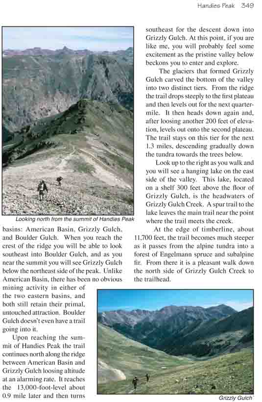
Upon reaching the summit of Handies Peak the trail
continues north along the ridge between American Basin and Grizzly Gulch
loosing altitude at an alarming rate. It reaches the 13,000-foot-level about
0.9 mile later and then turns southeast for the descent down into Grizzly
Gulch. At this point, if you are like me, you will probably feel some
excitement as the pristine valley below beckons you to enter and explore.
The glaciers that formed Grizzly Gulch carved the bottom
of the valley into two distinct tiers. From the ridge the trail drops
steeply to the first plateau and then levels out for the next quarter-mile.
It then heads down again and, after loosing another 200 feet of elevation,
levels out onto the second plateau. The trail stays on this tier for the
next 1.3 miles, descending gradually down the tundra towards the trees
below.
Look up to the right as you walk and you will see a
hanging lake on the east side of the valley. This lake, located on a shelf
300 feet above the floor of Grizzly Gulch, is the headwaters of Grizzly
Gulch Creek. A spur trail to the lake leaves the main trail near the point
where the trail meets the creek.
At the edge of timberline, about 11,700 feet, the trail
becomes much steeper as it passes from the alpine tundra into a forest of
Engelmann spruce and subalpine fir. From there it is a pleasant walk down
the north side of Grizzly Gulch Creek to the trailhead.