The Highland Mary Lakes are a group of seven
above-timberline lakes on the northwestern side of the Weminuche Wilderness
Area. This trail passes by the two largest Highland Mary Lakes as well as
the nearby Verde Lakes. But, in my opinion, the most interesting part of the
hike is the second half of the trail. From the Verde Lakes the trail turns
east and climbs to the top of the Continental Divide. It then follows the
Continental Divide Trail for 1.0 mile before turning west again for the
descent back to the trailhead. All but the first and last mile of the hike
are above timberline.
I should mention an interesting bit of history regarding
the Highland Mary Mine near the beginning of this hike. This mine was
originally established by the Ennis brothers who emigrated from New York to
Colorado in the early 1870s to try their luck at prospecting. Before leaving
home they hired a spiritualist to tell them where to dig for gold. Given a
map of the United States she confidently pointed to Cunningham Gulch and
told them that this was the place where they would find a "Lake of Gold".
The brothers struggled for over ten years, carefully following the mystic’s
instructions, until they had dug a mile-long tunnel into the mountain and
discovered a number of high grade silver deposits, but they never struck
gold. Finally, after spending a million dollars on the mine and $50,000 on
the spiritualist, they went bankrupt. The Highland Mary Mine was taken over
by new owners in 1895 and, ironically, by 1907 it had become the second
largest silver producing mine in the Silverton area.
From the trailhead the trail begins climbing upward
almost immediately along the left side of the creek. For the next 40
minutes you will rarely be out of sight or sound of Cunningham Creek as
it tumbles and splashes down the steep grade through a series of
delightful cascades. After 0.2 mile there is a fork in the trail with a
misleading sign that says hikers should bear right and horses bear left.
Be sure to bear right at this sign, or you will soon find yourself
climbing out of Cunningham Gulch toward the Continental Divide.
The trail continues up the left side of the main
drainage for another 0.9 mile, crossing two minor tributaries along the
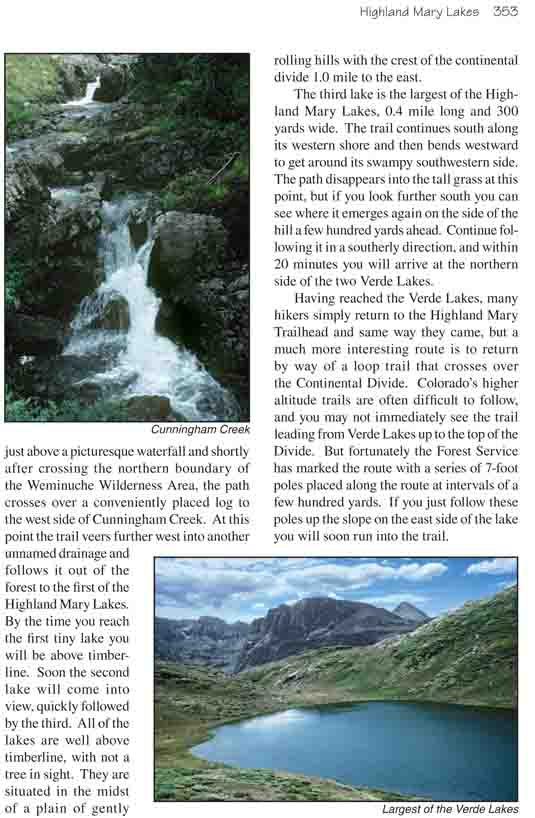
way. Then, just above a picturesque waterfall and shortly after crossing
the northern boundary of the Weminuche Wilderness Area, the path crosses over a
conveniently placed log to the west side of Cunningham Creek. At this point
the trail veers further west into another unnamed drainage and follows it
out of the forest to the first of the Highland Mary Lakes. By the time you
reach the first tiny lake you will be above timberline. Soon the second lake
will come into view, quickly followed by the third. All of the lakes are
well above timberline, with not a tree in sight. They are situated in the
midst of a plain of gently rolling hills with the crest of the continental
divide 1.0 mile to the east.
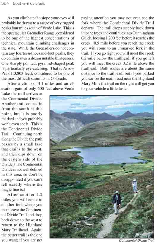
The third lake is the largest of the Highland Mary Lakes,
0.4 mile long and 300 yards wide. The trail continues south along its
western shore and then bends westward to get around its swampy southwestern
side. The path disappears into the tall grass at this point, but if you look
further south you can see where it emerges again on the side of the hill a
few hundred yards ahead. Continue following it in a southerly direction, and
within 20 minutes you will arrive at the northern side of the two Verde
Lakes.
Having reached the Verde Lakes, many hikers simply return
to the Highland Mary Trailhead and same way they came, but a much more
interesting route is to return by way of a loop trail that crosses over the
Continental Divide. Colorado’s higher altitude trails are often difficult to
follow, and you may not immediately see the trail leading from Verde Lakes
up to the top of the Divide. But fortunately the Forest Service has marked
the route with a series of 7-foot poles placed along the route at intervals
of a few hundred yards. If you just follow these poles up the slope on the
east side of the lake you will soon run into the trail.
As you climb up the slope your eyes will probably be
drawn to a range of very rugged peaks four miles south of Verde Lake. This
is the spectacular Grenadier Range, considered to be one of the highest
concentrations of technical mountain climbing challenges in the state. While
the Grenadiers do not contain any fourteen-thousand-foot peaks, they do
contain over a dozen notable thirteeners. One sharply pointed,
pyramid-shaped peak is particularly eye-catching. That is Arrow Peak (13,803
feet), considered to be one of the most difficult summits in Colorado.
After a climb of 1.1 miles and an elevation gain of only
600 feet above Verde Lake the trail arrives at the Continental Divide.
Another trail comes in from the south at this point, but it is poorly marked
and you probably won’t even see it. This is the Continental Divide Trail.
Continuing north along the Divide the path passes by a small lake that
drains to the west, and then dips down on the eastern side of the Divide.
(The Continental Divide is not well defined in this area, so don’t be
disappointed if you can’t tell exactly where the magic line is.)
After another 1.2 miles you will come to another fork where you must
leave the Continental Divide Trail and drop back down to the west to return
to the Highland Mary Trailhead. Again, the better trail is the one you want;
if you are not paying attention you may not even see the fork where the
Continental Divide Trail departs. The trail drops steeply back down into the
trees and continues into Cunningham Gulch, loosing 1,200 feet before it
reaches the creek. 0.5 mile before you reach the creek you will come to an
unmarked fork in the trail. If you go right you will meet the creek 0.2 mile
below the trailhead; if you go left you will meet the creek 0.2 mile above
the trailhead. Both routes are about the same distance to the trailhead, but
if you parked you car on the main road near the Highland Mary Mine the trail
on the right will get you to your vehicle a little faster.