This loop hike offers three scenic rewards, any one of
which would be enough to make the trip worthwhile. The first treat is the
beautiful Missouri Lakes Basin, with four large lakes and a half-dozen
smaller ones surrounded on three sides by peaks nearly 13,000 feet high. The
second point of interest is the view into the spectacular Cross Creek
glacial valley from the summits of Missouri Pass and Fancy Pass. And the
third reward is the opportunity to walk through Holy Cross City, a late
1800s mining town that lies just outside the wilderness boundary.
The hike can be completed without too much difficulty in
one 8 hour day; however a more leisurely walk of two days will allow you to
better enjoy the exceptional scenery and the historical mining town of Holy
Cross. If you are getting off to a late start you will find a number of fine
campsites in the Missouri Lakes Basin only three miles from the trailhead.
Otherwise, Fancy Lake is a fine place to pitch camp for the night. In
addition to the itinerary suggested here there are several opportunities for
more off-trail exploration, especially in the area west of Holy Cross City.
As you begin this hike you will notice the presence of a
large aqueduct that goes underground near the trailhead. This structure
provides a poignant reminder of the uphill battle faced by western
conservationists in their never-ending struggle to protect the region's
wilderness. There is almost always something in these wild places that
somebody wants; in the case of the Holy Cross Wilderness it is water.
In 1962 the cities of Aurora and Colorado Springs
obtained the water rights to much of the land that is now included in the
Holy Cross Wilderness Area. Work began almost immediately on the Homestake
Water Diversion Project, and by the time the wilderness was designated in
1980 the first phase of the water collection plan had been completed. The
boundaries of the new wilderness area had to be adjusted to exclude the
roads, pipes, and reservoirs created by the project, but local
environmentalists were able to prevent phase two of the Homestake Project
from proceeding. Today most of the land within the Holy Cross boundaries is
still pristine; however sections are still at risk. For the past 20 years
concerned citizens have been waging a series of legal battles to prevent
Aurora and Colorado Springs from dewatering the high alpine valleys of Cross
Creek and Fall Creek. The fight continues today, with no guarantee that the
courts won't ultimately rule against them.
Day 1 (5.8 miles)
For the first mile the trail to Missouri Lakes seems to
be following an old abandoned roadbed. Actually a huge pipe is buried under
this section of trail; it intercepts Missouri Creek just outside of the
wilderness area to carry water from the drainage to Homestake Reservoir (all
part of the Homestake Water Diversion Project). 0.6 mile from the trailhead
the path meets one of the service roads for the aqueduct, where there is an
alternative trailhead. Beyond that the trail veers west and north, and after
another 0.4 miles it enters Holy Cross Wilderness Area.
I almost always experience a feeling of excitement,
anticipation and relief when I see one of the familiar wooden signs that
mark wilderness area boundaries. But nowhere is that feeling more intense
than along the Missouri Lakes trail. It is impossible not to notice the
difference before and beyond that sign. On one side, the forest as God
created it; on the other, the forest as Man has modified it. It is a lesson
that is bound to stick in the mind of anyone who walks this trail.
For the next 1.7 miles the route never strays far from
the delightfully picturesque Missouri Creek. Log footbridges cross the
stream on several occasions, once just below a particularly pretty cascade
where the creek cuts through a layer of black schist. Finally the trail
breaks out of the trees into the Missouri Lakes Basin, a relatively flat,
open pocket of alpine tundra that lies just below timberline. 1,500 feet
above the basin the deep blue sky touches a rugged surrounding skyline of
granite and schist peaks. And scattered amidst the wildflowers on the bottom
of the tundra are a half dozen cold blue lakes, the largest of which is a
quarter-mile long.
For the next mile the trail meanders through the basin,
passing by three of the largest lakes. If you want to see the fourth lake
you must turn left on a 0.3 mile spur trail that leaves the main trail
shortly after you enter the basin. As you near the northern side of the
basin the trail begins to climb, and soon you will start switchbacking up
the stony terrain towards Missouri Pass, the low point on the surrounding
ridge. The trail is fairly steep in a few places, but it doesn't last long.
After a 400-foot climb you will reach the top, where you should pause to
look back for another fine view of the Missouri Lakes Basin before you cross
the pass.
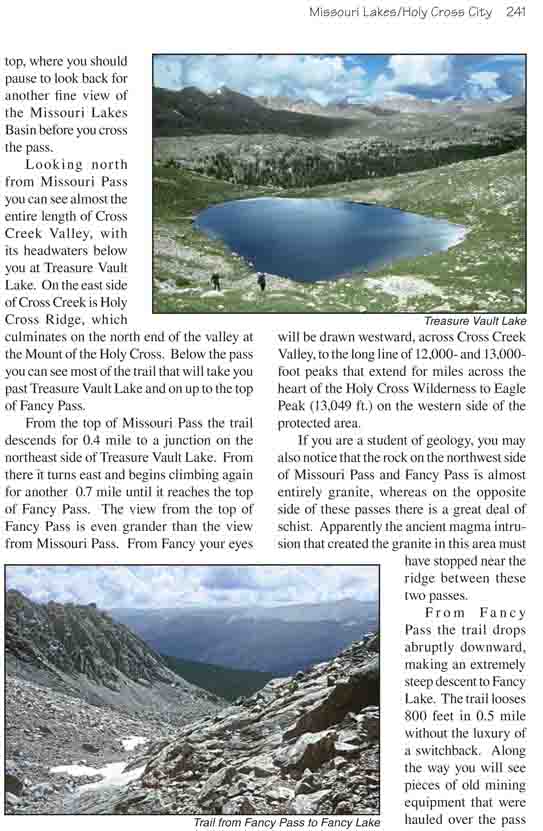
Looking north from Missouri Pass you can see almost the
entire length of Cross Creek Valley, with its headwaters below you at
Treasure Vault Lake. On the east side of Cross Creek is Holy Cross Ridge,
which culminates on the north end of the valley at the Mount of the Holy
Cross. Below the pass you can see most of the trail that will take you past
Treasure Vault Lake and on up to the top of Fancy Pass.
From the top of Missouri Pass the trail descends for 0.4
mile to a junction on the northeast side of Treasure Vault Lake. From there
it turns east and begins climbing again for another 0.7 mile until it
reaches the top of Fancy Pass. The view from the top of Fancy Pass is even
grander than the view from Missouri Pass. From Fancy your eyes will be drawn
westward, across Cross Creek Valley, to the long line of 12,000- and
13,000-foot peaks that extend for miles across the heart of the Holy Cross
Wilderness to Eagle Peak (13,049 ft.) on the western side of the protected
area.
If you are a student of geology, you may also notice that
the rock on the northwest side of Missouri Pass and Fancy Pass is almost
entirely granite, whereas on the opposite side of these passes there is a
great deal of schist. Apparently the ancient magma intrusion that created
the granite in this area must have stopped near the ridge between these two
passes.
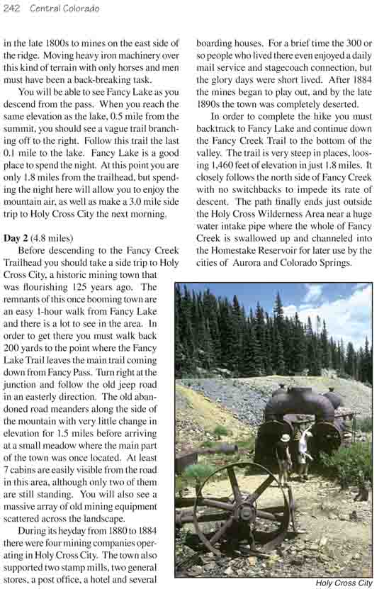
From Fancy Pass the trail drops abruptly downward, making
an extremely steep descent to Fancy Lake. The trail looses 800 feet in 0.5
mile without the luxury of a switchback. Along the way you will see pieces
of old mining equipment that were hauled over the pass in the late 1800s to
mines on the east side of the ridge. Moving heavy iron machinery over this
kind of terrain with only horses and men must have been a back-breaking
task.
You will be able to see Fancy Lake as you descend from
the pass. When you reach the same elevation as the lake, 0.5 mile from the
summit, you should see a vague trail branching off to the right. Follow this
trail the last 0.1 mile to the lake. Fancy Lake is a good place to spend the
night. At this point you are only 1.8 miles from the trailhead, but spending
the night here will allow you to enjoy the mountain air, as well as make a
3.0 mile side trip to Holy Cross City the next morning.
Day 2 (4.8 miles)
Before descending to the Fancy Creek Trailhead you should
take a side trip to Holy Cross City, a historic mining town that was
flourishing 125 years ago. The remnants of this once booming town are an
easy 1-hour walk from Fancy Lake and there is a lot to see in the area. In
order to get there you must walk back 200 yards to the point where the Fancy
Lake Trail leaves the main trail coming down from Fancy Pass. Turn right at
the junction and follow the old jeep road in an easterly direction. The old
abandoned road meanders along the side of the mountain with very little
change in elevation for 1.5 miles before arriving at a small meadow where
the main part of the town was once located. At least 7 cabins are easily
visible from the road in this area, although only two of them are still
standing. You will also see a massive array of old mining equipment
scattered across the landscape.
During its heyday from 1880 to 1884 there were four
mining companies operating in Holy Cross City. The town also supported two
stamp mills, two general stores, a post office, a hotel and several boarding
houses. For a brief time the 300 or so people who lived there even enjoyed a
daily mail service and stagecoach connection, but the glory days were short
lived. After 1884 the mines began to play out, and by the late 1890s the
town was completely deserted.
In order to complete the hike you must backtrack to Fancy Lake and
continue down the Fancy Creek Trail to the bottom of the valley. The trail
is very steep in places, loosing 1,460 feet of elevation in just 1.8 miles.
It closely follows the north side of Fancy Creek with no switchbacks to
impede its rate of descent. The path finally ends just outside the Holy
Cross Wilderness Area near a huge water intake pipe where the whole of Fancy
Creek is swallowed up and channeled into the Homestake Reservoir for later
use by the cities of Aurora and Colorado Springs.