If you are interested in Colorado’s early settlers and
want to learn more about how and where they lived this hike will be of
special interest to you. Homestead Meadows was added to the National
Registry of Historic Places in 1990, and it is now a protected area managed
by the Forest Service. The area contains no fewer than eight century-old
homesteads. Many of the original buildings are still standing, and the
trails leading to the homesteads are the old wagon roads that residents once
used to access their homes. The sites provide a fascinating window into what
life on the frontier was like at the turn of the last century.
To make the hike even more interesting the Forest Service
has placed plaques at each of the eight homesteads to provide information
about who lived there. One plaque describes a teenage girl who rode her
horse all the way to Estes Park to attend high school. Another describes how
one young girl passed the lonely winter evenings playing dominoes and
listening to her father play the fiddle. And still another plaque describes
how one of the cabins was used in the early 1950s as a schoolhouse for the
four remaining children who still lived in the area. Theirs was a life far
different from the life we know in Colorado today.
From the trailhead the trail drops down slightly to
cross the Little Thompson River, and then turns west to begin following
Lion Gulch up to Homestead Meadows. Initially the trail is in an open
forest of ponderosa pines, but when it enters the gulch the scene
changes dramatically. Lion Gulch is a beautiful riparian area with more
species of green plants that you can imagine. The well shaded path
proceeds upward along a gradual grade, gaining 1,080 feet over the next
2.5 miles.
As you near the meadows the trail levels out and
heads due west along the north side of the stream. If you are observant
you may see the rusted remains of what appears to be a model-T Ford in
the bushes 25 feet below the left side of the trail. Then, just 3
minutes beyond the old car, you will come to the first Forest Service
plaque, offering a brief description of the 1862 Homestead Act. This act
allowed settlers to gain title to 160 acres of land simply by building a
small dwelling on the land and living on it at least half the time for a
period of 5 years. Alternatively a settler could obtain title to his
homestead in only 6 months by paying the government $200.00, but few
people had that kind of money at that time.
Soon after reading the first plaque you will come to a
trail junction where you must make a decision. The Engert, Laycock, Boren,
and Hill homesteads are all on the trail to the left, while the Walker,
Griffith, Irvin, and Brown homesteads are all straight ahead. If you want to
see all of the homesteads the total round trip walking distance from your
car will be 16.5 miles, so unless you are planning the trip as an
overnighter you will probably want to see only a few of them. In my opinion,
the Irvin Homestead is the most interesting of the eight homesteads, so if
you are planning to do this hike in a single day and need to make a choice I
suggest you bear right at the junction and see the Walker, Griffith, Irvin,
and Brown homesteads.
Five minutes after leaving the junction you will come
to the first homestead site, deeded to Sarah Walker in 1914. There isn’t
much left of the Walker cabin, but Sarah must have been a lady filled
with grit and determination. She left England around the turn of the
century and moved to Lyons, Colorado, in 1908. Later, after loosing her
husband and two children, she settled in Homestead Meadows and lived
there until around 1925. She was the only single woman to homestead in
the area.
Another 0.2 mile beyond the Walker homestead you will
come to the remains of three old cabins on a plot of land that was purchased
from the state of Colorado by William Griffith in 1923. Griffith lived there
until his death in 1936.
From the Griffith homestead to the Irvin homestead is 1.1
miles along an old wagon road that once served a sawmill on the Irvin
property. Along the way you will pass two other trails that branch off to
the left towards the Brown homestead. You will probably want to visit the
Brown property on the way back.
The Irvin homestead was first deeded to Frank Irvin in
1917 and later owned by R. J. Nettleton. Nettleton operated a sawmill there
and also raised rabbit pelts for sale to the US Army during World War II. In
the 1960s the homestead was developed as a hunting camp, and there are still
at least 7 buildings on the property in various states of disrepair.
Unfortunately there is not much left of the old sawmill except an old gear
rack and a sledge that was probably used for dragging logs to the mill.
Retracing your footsteps 0.7 mile from the Irvin
homestead will bring you back to the beginning of the Meadow Loop Trail that
passes the Brown homestead. Turn right here and walk north on Road 120.
After 15 minutes you will arrive at a junction where you must turn left onto
Road 120A. The Brown homestead is a 5-minute walk from the junction.
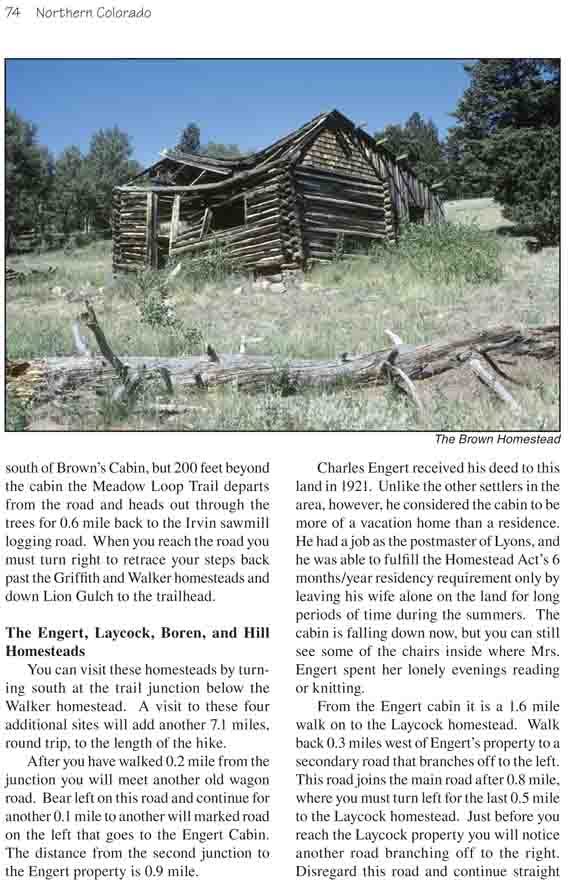
The 320-acre Brown homestead was first deeded to brothers
Harry and Cloyd Brown in 1917 and 1919, and Harry raised cattle and sold
timber from the property until the 1930s. Today the property still has one
cabin standing on it. The old cabin contains a number of interesting
artifacts including an old-fashion stove.
Road 120A enters private property just south of Brown’s
Cabin, but 200 feet beyond the cabin the Meadow Loop Trail departs from the
road and heads out through the trees for 0.6 mile back to the Irvin sawmill
logging road. When you reach the road you must turn right to retrace your
steps back past the Griffith and Walker homesteads and down Lion Gulch to
the trailhead.
The Engert, Laycock, Boren, and Hill Homesteads
You can visit these homesteads by turning south at the
trail junction below the Walker homestead. A visit to these four additional
sites will add another 7.1 miles, round trip, to the length of the hike.
After you have walked 0.2 mile from the junction you will
meet another old wagon road. Bear left on this road and continue for another
0.1 mile to another will marked road on the left that goes to the Engert
Cabin. The distance from the second junction to the Engert property is 0.9
mile.
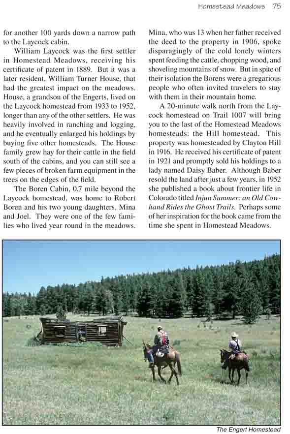
Charles Engert received his deed to this land in 1921.
Unlike the other settlers in the area, however, he considered the cabin to
be more of a vacation home than a residence. He had a job as the postmaster
of Lyons, and he was able to fulfill the Homestead Act’s 6 months/year
residency requirement only by leaving his wife alone on the land for long
periods of time during the summers. The cabin is falling down now, but you
can still see some of the chairs inside where Mrs. Engert spent her lonely
evenings reading or knitting.
From the Engert cabin it is a 1.6 mile walk on to the
Laycock homestead. Walk back 0.3 miles west of Engert’s property to a
secondary road that branches off to the left. This road joins the main road
after 0.8 mile, where you must turn left for the last 0.5 mile to the
Laycock homestead. Just before you reach the Laycock property you will
notice another road branching off to the right. Disregard this road and
continue straight for another 100 yards down a narrow path to the Laycock
cabin.
William Laycock was the first settler in Homestead
Meadows, receiving his certificate of patent in 1889. But it was a later
resident, William Turner House, that had the greatest impact on the meadows.
House, a grandson of the Engerts, lived on the Laycock homestead from 1933
to 1952, longer than any of the other settlers. He was heavily involved in
ranching and logging, and he eventually enlarged his holdings by buying five
other homesteads. The House family grew hay for their cattle in the field
south of the cabins, and you can still see a few pieces of broken farm
equipment in the trees on the edges of the field.
The Boren Cabin, 0.7 mile beyond the Laycock homestead,
was home to Robert Boren and his two young daughters, Mina and Joel. They
were one of the few families who lived year round in the meadows. Mina, who
was 13 when her father received the deed to the property in 1906, spoke
disparagingly of the cold lonely winters spent feeding the cattle, chopping
wood, and shoveling mountains of snow. But in spite of their isolation the
Borens were a gregarious people who often invited travelers to stay with
them in their mountain home.
A 20-minute walk north from the Laycock homestead on
Trail 1007 will bring you to the last of the Homestead Meadows homesteads:
the Hill homestead. This property was homesteaded by Clayton Hill in 1916.
He received his certificate of patent in 1921 and promptly sold his holdings
to a lady named Daisy Baber. Although Baber resold the land after just a few
years, in 1952 she published a book about frontier life in Colorado titled
Injun Summer: an Old Cowhand Rides the Ghost Trails. Perhaps some of
her inspiration for the book came from the time she spent in Homestead
Meadows.