I must admit I have a certain passion for glaciers, even
small ones, but if I had to choose the one glacier in Colorado that stirs my
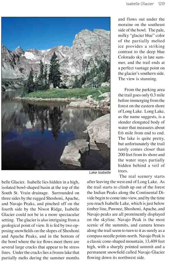
soul the most, it would have to be Isabelle Glacier. Isabelle lies hidden in
a high, isolated bowl-shaped basin at the top of the South St. Vrain
drainage. Surrounded on three sides by the rugged Shoshoni, Apache, and
Navajo Peaks, and pinched off on the fourth side by the Niwot Ridge,
Isabelle Glacier could not be in a more spectacular setting. The glacier is
also intriguing from a geological point of view. It is fed by two opposing
snowfields on the slopes of Shoshoni and Apache Peaks, and in the bottom of
the bowl where the ice flows meet there are several large cracks that appear
to be stress lines. Under the cracks lies a frozen lake that partially melts
during the summer months and flows out under the moraine on the southeast
side of the bowl. The pale, milky "glacier blue" color of the partially
melted ice provides a striking contrast to the deep blue Colorado sky in
late summer, and the trail ends at a perfect vantage point on the glacier’s
southern side. The view is stunning.
From the parking area the trail goes only 0.3 mile
before immerging from the forest on the eastern shore of Long Lake. Long
Lake, as the name suggests, is a slender elongated body of water that
measures about 0.6 mile from end to end. The lake is quite pretty, but
unfortunately the trail rarely comes closer than 200 feet from its shore
and the water stays partially hidden behind a veil of trees.
The real scenery starts after leaving the west end of
Long Lake. As the trail starts to climb up out of the forest the Indian
Peaks along the Continental Divide begin to come into view, and by the
time you reach Isabelle Lake, which is just below timber line, Pawnee,
Shoshoni, Apache, and Navajo peaks are all prominently displayed on the
skyline. Navajo Peak is the most scenic of the summits, and camera
lenses along the trail seem to turn to it as surely as a compass needle
points north. Navajo Peak is a classic cone-shaped mountain, 13,409 feet
high, with a sharply pointed summit and a permanent snowfield called
Navajo Glacier flowing down its northwest side.
The trail continues along the north side of Isabelle Lake
to the junction with the Pawnee Pass Trail, and then bears left along the
upper reaches of South St. Vrain Creek. More climbing is in order here; you
still have another 1,100 feet of elevation gain to realize before arriving
at the foot of Isabelle Glacier. Most other hikers will be left behind as
you leave Isabelle Lake; only a small percentage of them make it all the way
to the glacier.
A mile after you leave the lake you will come to a small
picturesque tarn in the valley below the glaciers. You cannot see Isabelle
Glacier yet, but Navajo Glacier is starkly apparent across the treeless
tundra a half-mile southwest of the tarn. Navajo Peak looks to be little
more than a stone’s throw away, but actually it is 0.7 mile distant and
2,000 feet above the trail. The most common mountaineering route to the top
of Navajo departs from the trail at this point, climbs to the top of Niwot
Ridge, and approaches the peak from the side opposite Navajo Glacier.
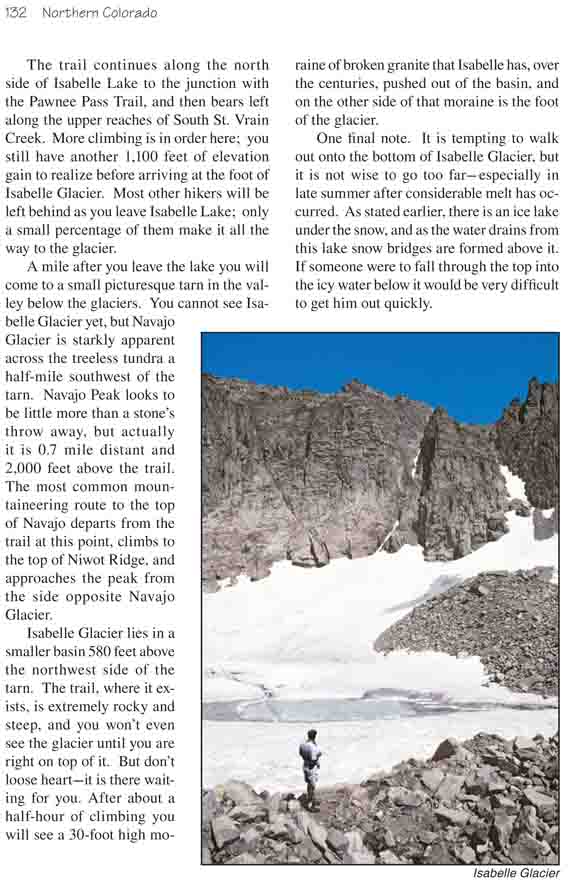
Isabelle Glacier lies in a smaller basin 580 feet above
the northwest side of the tarn. The trail, where it exists, is extremely
rocky and steep, and you won’t even see the glacier until you are right on
top of it. But don’t loose heart-it is there waiting for you. After about a
half-hour of climbing you will see a 30-foot high moraine of broken granite
that Isabelle has, over the centuries, pushed out of the basin, and on the
other side of that moraine is the foot of the glacier.
One final note. It is tempting to walk out onto the
bottom of Isabelle Glacier, but it is not wise to go too far-especially in
late summer after considerable melt has occurred. As stated earlier, there
is an ice lake under the snow, and as the water drains from this lake snow
bridges are formed above it. If someone were to fall through the top into
the icy water below it would be very difficult to get him out quickly.