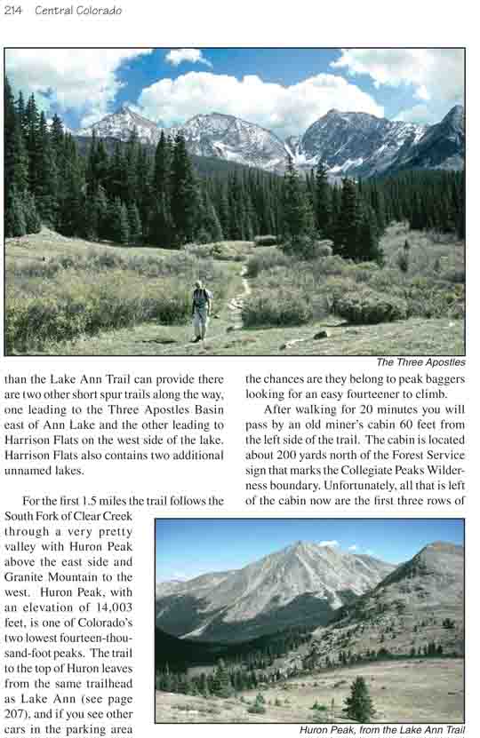
Lake Ann is an alpine gem that lies just south of the
Continental Divide and west of three picturesque summits known as the Three
Apostles. The lake is also on the Continental Divide Trail; consequently it
is a popular camping area for summer backpackers. From Lake Ann the trail
climbs another 800 feet to the top of the Divide and then drops down its
south side towards Illinois Creek. For those that seek more solitude than
the Lake Ann Trail can provide there are two other short spur trails along
the way, one leading to the Three Apostles Basin east of Ann Lake and the
other leading to Harrison Flats on the west side of the lake. Harrison Flats
also contains two additional unnamed lakes.
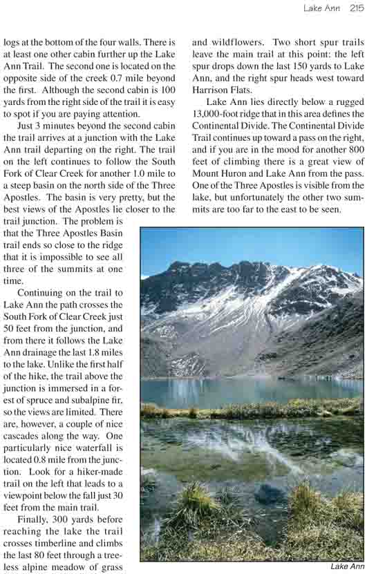
For the first 1.5 miles the trail follows the South
Fork of Clear Creek through a very pretty valley with Huron Peak above
the east side and Granite Mountain to the west. Huron Peak, with an
elevation of 14,003 feet, is one of Colorado’s two lowest
fourteen-thousand-foot peaks. The trail to the top of Huron leaves from
the same trailhead as Lake Ann (see page 207), and if you see other cars
in the parking area the chances are they belong to peak baggers looking
for an easy fourteener to climb.
After walking for 20 minutes you will pass by an old
miner’s cabin 60 feet from the left side of the trail. The cabin is
located about 200 yards north of the Forest Service sign that marks the
Collegiate Peaks Wilderness boundary. Unfortunately, all that is left of
the cabin now are the first three rows of logs at the bottom of the four
walls. There is at least one other cabin further up the Lake Ann Trail.
The second one is located on the opposite side of the creek 0.7 mile
beyond the first. Although the second cabin is 100 yards from the right
side of the trail it is easy to spot if you are paying attention.
Just 3 minutes beyond the second cabin the trail arrives
at a junction with the Lake Ann trail departing on the right. The trail on
the left continues to follow the South Fork of Clear Creek for another 1.0
mile to a steep basin on the north side of the Three Apostles. The basin is
very pretty, but the best views of the Apostles lie closer to the trail
junction. The problem is that the Three Apostles Basin trail ends so close
to the ridge that it is impossible to see all three of the summits at one
time.
Continuing on the trail to Lake Ann the path crosses the
South Fork of Clear Creek just 50 feet from the junction, and from there it
follows the Lake Ann drainage the last 1.8 miles to the lake. Unlike the
first half of the hike, the trail above the junction is immersed in a forest
of spruce and subalpine fir, so the views are limited. There are, however, a
couple of nice cascades along the way. One particularly nice waterfall is
located 0.8 mile from the junction. Look for a hiker-made trail on the left
that leads to a viewpoint below the fall just 30 feet from the main trail.
Finally, 300 yards before reaching the lake the trail
crosses timberline and climbs the last 80 feet through a treeless alpine
meadow of grass and wildflowers. Two short spur trails leave the main trail
at this point: the left spur drops down the last 150 yards to Lake Ann, and
the right spur heads west toward Harrison Flats.
Lake Ann lies directly below a rugged 13,000-foot ridge
that in this area defines the Continental Divide. The Continental Divide
Trail continues up toward a pass on the right, and if you are in the mood
for another 800 feet of climbing there is a great view of Mount Huron and
Lake Ann from the pass. One of the Three Apostles is visible from the lake,
but unfortunately the other two summits are too far to the east to be seen.