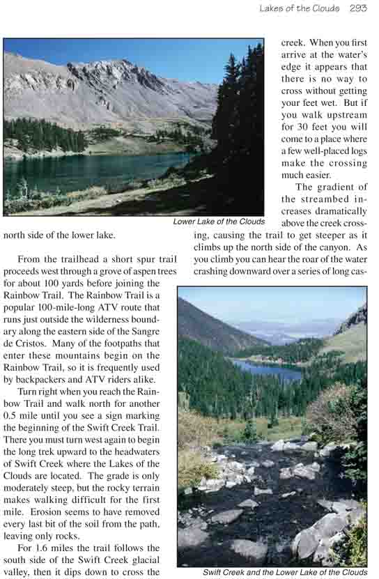
Three very pleasant high-altitude lakes on the east side
of the Sangre de Cristo Mountains are the goal of this hike. The lakes are
situated on the edge of timberline in a high alpine valley that is almost
completely surrounded by 13,000-foot peaks. One of the peaks, Spread Eagle
Peak (13,423 ft.) is only 0.6 mile southeast of the lower lake, and is a
popular climb for those looking for an additional challenge. All three lakes
also support a thriving population of cutthroat trout, and if you want to
spend more time in the area you will find some nice camping spots beneath
the trees on the north side of the lower lake.
From the trailhead a short spur trail proceeds west
through a grove of aspen trees for about 100 yards before joining the
Rainbow Trail. The Rainbow Trail is a popular 100-mile-long ATV route
that runs just outside the wilderness boundary along the eastern side of
the Sangre de Cristos. Many of the footpaths that enter these mountains
begin on the Rainbow Trail, so it is frequently used by backpackers and
ATV riders alike.
Turn right when you reach the Rainbow Trail and walk
north for another 0.5 mile until you see a sign marking the beginning of
the Swift Creek Trail. There you must turn west again to begin the long
trek upward to the headwaters of Swift Creek where the Lakes of the
Clouds are located. The grade is only moderately steep, but the rocky
terrain makes walking difficult for the first mile. Erosion seems to
have removed every last bit of the soil from the path, leaving only
rocks.
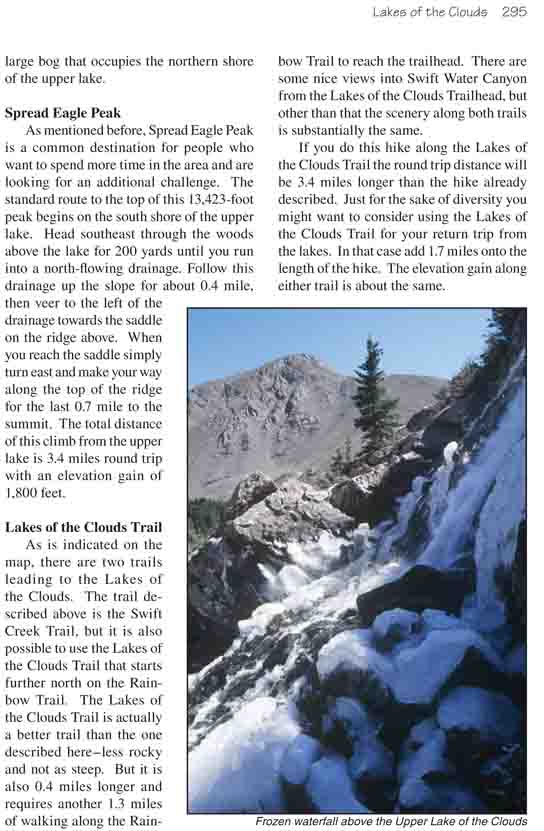
For 1.6 miles the trail follows the south side of the
Swift Creek glacial valley, then it dips down to cross the creek. When you
first arrive at the water’s edge it appears that there is no way to cross
without getting your feet wet. But if you walk upstream for 30 feet you will
come to a place where a few well-placed logs make the crossing much easier.
The gradient of the streambed increases dramatically
above the creek crossing, causing the trail to get steeper as it climbs up
the north side of the canyon. As you climb you can hear the roar of the
water crashing downward over a series of long cascades below the trees on
your left. After 5 minutes the path again levels out, and if you are
observant you will see a vague spur trail branching off toward a viewpoint
above one to the waterfalls. Unfortunately, however, the view is seriously
obstructed by the trees, and to get closer would require some major
bushwhacking.
0.7 mile after crossing the stream the trail arrives at
the junction where the Swift Creek Trail meets the Lakes of the Clouds
Trail. Soon it approaches the water again, passing through an area of
near-perfect creek-side campsites, and then heads upward along the base of a
steep scree field. Finally, as you approach timberline, the path levels out
to become a more pleasant walk. You should arrive at the lower Lake of the
Clouds about 45 minutes after leaving the trail junction.
The most notable thing you will see as you approach the
lower lake is the distinctive Spread Eagle Peak, a cone-shaped thirteener
that rises from the south shore of the lake just over a half-mile away. The
mountain is most impressive when viewed around sunset during the summer
months when the sun is in the northwest. It towers above the lake like a
gigantic Egyptian pyramid.
The trail proceeds along the western side of the lower
lake for 200 yards before veering away toward the outlet of the middle lake.
Just before reaching the outlet the trail splits, with the right fork
circling around the middle lake and the left fork going directly to the
south shore of the upper lake. The trail to the right eventually ends on the
edge of a large bog that occupies the northern shore of the upper lake.
Spread Eagle Peak
As mentioned before, Spread Eagle Peak is a common
destination for people who want to spend more time in the area and are
looking for an additional challenge. The standard route to the top of this
13,423-foot peak begins on the south shore of the upper lake. Head southeast
through the woods above the lake for 200 yards until you run into a
north-flowing drainage. Follow this drainage up the slope for about 0.4
mile, then veer to the left of the drainage towards the saddle on the ridge
above. When you reach the saddle simply turn east and make your way along
the top of the ridge for the last 0.7 mile to the summit. The total distance
of this climb from the upper lake is 3.4 miles round trip with an elevation
gain of 1,800 feet.
Lakes of the Clouds Trail
As is indicated on the map, there are two trails leading
to the Lakes of the Clouds. The trail described above is the Swift Creek
Trail, but it is also possible to use the Lakes of the Clouds Trail that
starts further north on the Rainbow Trail. The Lakes of the Clouds Trail is
actually a better trail than the one described here-less rocky and not as
steep. But it is also 0.4 miles longer and requires another 1.3 miles of
walking along the Rainbow Trail to reach the trailhead. There are some nice
views into Swift Water Canyon from the Lakes of the Clouds Trailhead, but
other than that the scenery along both trails is substantially the same.
If you do this hike along the Lakes of the Clouds Trail the round trip
distance will be 3.4 miles longer than the hike already described. Just for
the sake of diversity you might want to consider using the Lakes of the
Clouds Trail for your return trip from the lakes. In that case add 1.7 miles
onto the length of the hike. The elevation gain along either trail is about
the same.