Like most of the alpine lakes in Colorado, Lamphier
Lake is a glacial tarn that was scooped out of the surrounding rock
during the last ice age. The well-protected lake lies just below
timberline, and is surrounded on three sides by Broncho Mountain, Square
Top Mountain, and Fossil Mountain. Lamphier is particularly scenic early
in the morning when Square Top Mountain is reflected from its shaded,
mirror-smooth surface; if you are interested in seeing this morning
spectacle you will find several fine camping sites in the trees along
its eastern shore.
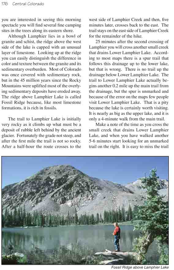
Although Lamphier lies in a bowl of granite and
schist, the ridge above the west side of the lake is capped with an
unusual layer of limestone. Looking up at the ridge you can easily
distinguish the difference in color and texture between the granite and
its sedimentary overburden. Most of Colorado was once covered with
sedimentary rock, but in the 45 million years since the Rocky Mountains
were uplifted most of the overlying sedimentary deposits have eroded
away. The ridge above Lamphier Lake is called Fossil Ridge because, like
most limestone formations, it is rich in fossils.
The trail to Lamphier Lake is initially very rocky as
it climbs up what must be a deposit of rubble left behind by the ancient
glacier. Fortunately the grade not steep, and after the first mile the
trail is not so rocky. After a half-hour the route crosses to the west
side of Lamphier Creek and then, five minutes later, crosses back to the
east. The trail stays on the east side of Lamphier Creek for the
remainder of the hike.
25 minutes after the second crossing of Lamphier you will
cross another small creek that drains Lower Lamphier Lake. According to most
maps there is a spur trail that follows this drainage up to the lower lake,
but that is wrong. There is no trail up the drainage below Lower Lamphier
Lake. The trail to Lower Lamphier Lake actually begins another 0.2 mile up
the main trail from the drainage, but the spur is unmarked and because of
the error on the maps few people visit Lower Lamphier Lake. That is a pity
because the lake is certainly worth visiting. It is nearly as big as the
upper lake, and it is only a 4-minute walk from the main trail.
Make a note of the time as you cross the small creek that
drains Lower Lamphier Lake, and when you have walked another 5-6 minutes
start looking for an unmarked trail on the right. It is easy to miss the
trail if you aren’t looking for it, but if you are observant you should be
able to see it. There are also two old blaze marks on nearby trees at the
point where the unmarked trail branches off.
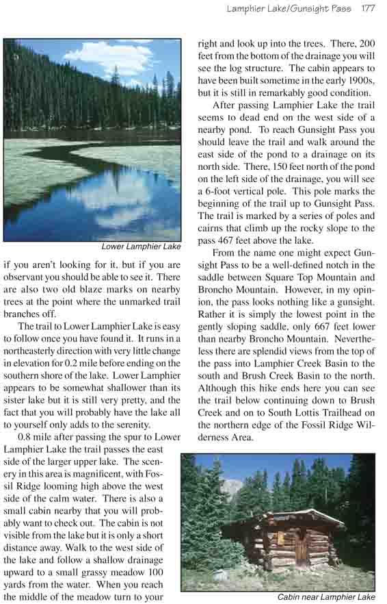
The trail to Lower Lamphier Lake is easy to follow once
you have found it. It runs in a northeasterly direction with very little
change in elevation for 0.2 mile before ending on the southern shore of the
lake. Lower Lamphier appears to be somewhat shallower than its sister lake
but it is still very pretty, and the fact that you will probably have the
lake all to yourself only adds to the serenity.
0.8 mile after passing the spur to Lower Lamphier Lake
the trail passes the east side of the larger upper lake. The scenery in this
area is magnificent, with Fossil Ridge looming high above the west side of
the calm water. There is also a small cabin nearby that you will probably
want to check out. The cabin is not visible from the lake but it is only a
short distance away. Walk to the west side of the lake and follow a shallow
drainage upward to a small grassy meadow 100 yards from the water. When you
reach the middle of the meadow turn to your right and look up into the
trees. There, 200 feet from the bottom of the drainage you will see the log
structure. The cabin appears to have been built sometime in the early 1900s,
but it is still in remarkably good condition.
After passing Lamphier Lake the trail seems to dead end
on the west side of a nearby pond. To reach Gunsight Pass you should leave
the trail and walk around the east side of the pond to a drainage on its
north side. There, 150 feet north of the pond on the left side of the
drainage, you will see a 6-foot vertical pole. This pole marks the beginning
of the trail up to Gunsight Pass. The trail is marked by a series of poles
and cairns that climb up the rocky slope to the pass 467 feet above the
lake.
From the name one might expect Gunsight Pass to be a well-defined notch
in the saddle between Square Top Mountain and Broncho Mountain. However, in
my opinion, the pass looks nothing like a gunsight. Rather it is simply the
lowest point in the gently sloping saddle, only 667 feet lower than nearby
Broncho Mountain. Nevertheless there are splendid views from the top of the
pass into Lamphier Creek Basin to the south and Brush Creek Basin to the
north. Although this hike ends here you can see the trail below continuing
down to Brush Creek and on to South Lottis Trailhead on the northern edge of
the Fossil Ridge Wilderness Area.