This hike follows two separate trails that can be
combined to form an interesting loop. The first half of the loop will take
you through a lush pinion-juniper forest on the top of Monument Mesa to the
rim overlooking Grand Valley. The trail then passes by the Liberty Cap, a
small dome-shaped sandstone formation, before dropping off the rim to join
the Ute Canyon trail below. The return route winds westward through the
bottom of a wide, scenic desert canyon surrounded by high cliffs of Wingate
Sandstone. Before beginning the hike you may want to drive to the Ute Canyon
Overlook, 1.9 miles south of Ute Canyon Trailhead on the Rimrock Road. This
viewpoint offers an outstanding view of Ute Canyon. From there you will be
able to see almost all of the last 4 miles of the route your hike will
follow.
If you wish to shorten the hike, you can walk either the
Liberty Cap Trail or the Ute Canyon Trail separately, ending your walk at
the lower Liberty Cap Trailhead on Highway 340. If you do this, however, you
will need a shuttle car to get back into the national monument. (From the
lower trailhead it is 13.0 miles to Ute Canyon Trailhead, or 16.0 miles to
Liberty Cap Trailhead.)
The loop hike can be done in either direction, but if you
are starting early in the day it is probably best to start at the Liberty
Cap Trailhead. The reason for this is that the second half of the hike is in
the bottom of a canyon where the opportunities for good photographs are
better when the sun is high.
The first half of the hike winds eastward across the
Morrison Formation on an old two-track wagon road that was closed by the
Park Service in the early 1970s. The remnant of the old road winds
across a landscape of pinion, juniper, and sagebrush on the top of
Monument Mesa for a distance of 4.3 miles before finally loosing its
identity as a road. It isn’t clear what the original purpose of the road
was-maybe it was used by ranchers who grazed cattle on the mesa. If that
is the case, it was long ago, because there is no evidence now that the
land was ever used for grazing. The grass and other vegetation is lush
and verdant as only ungrazed land can be.
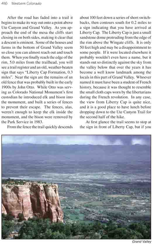
After the road has faded into a trail it begins to
make its way out onto a point above Ute Canyon and Grand Valley. As you
approach the end of the mesa the cliffs start closing in on both sides,
making it clear that a descent is eminent. Some of the houses and farms
in the bottom of Grand Valley seem so close you can almost reach out and
touch them. When you finally reach the edge of the rim, 5.0 miles from
the trailhead, you will see a trail register and an old, weather-beaten
sign that says "Liberty Cap Formation, 0.3 miles". Near the sign are the
remains of an old fence that was probably built in the early 1900s by
John Otto. While Otto was serving as Colorado National Monument’s first
custodian he introduced elk and bison into the monument, and built a
series of fences to prevent their escape. The fences, alas, weren’t
enough to keep the elk inside the monument, and the bison were removed
by the Park Service in 1983.
From the fence the trail quickly descends about 100 feet
down a series of short switchbacks, then contours south for 0.2 miles to a
sign indicating that you have arrived at Liberty Cap. The Liberty Cap is
just a small sandstone dome protruding from the edge of the rim above the
Wingate cliffs. It is only 50 feet high and may be a disappointment to some
people. If it were located elsewhere it probably wouldn’t even have a name,
but it stands out so distinctly against the sky from the valley below that
over the years it has become a well know landmark among the locals in this
part of Grand Valley. Whoever named it must have been a student of French
history, because it was thought to resemble the small cloth caps worn by the
libertarians during the French revolution. In any case, the view from
Liberty Cap is quite nice, and it is a good place to have lunch before
dropping down to the Ute Canyon Trail for the second half of the hike.
At first glance the trail seems to stop at the sign in
front of Liberty Cap, but if you look carefully you will see a small cairn
on the edge of the rim about 80 feet beyond the sign. Continue walking along
the rim towards Liberty Cap until you see this cairn, then turn left and you
will be on the trail. The trail immediately starts downward, but then
doubles back under itself to the north again. There is a break in the cliff
about 0.3 mile northwest of the Liberty Cap, and after the trail reaches
this break it turns downward once more, descending through a series of
switchbacks to the bench below the Wingate cliffs. Finally, 0.9 mile after
leaving Liberty Cap you will come to a trail junction where you must turn
right onto the Ute Canyon Trail. The left fork leads to the lower Liberty
Cap Trailhead, 1.1 miles from the junction.
From the junction, the Ute Canyon trail proceeds
southward for about 0.3 mile, then gradually turns west into the mouth of
Ute Canyon. Ute Canyon is one of many short, scenic canyons that have been
etched into the eastern edge of the Uncompahgre Plateau over the last 50
million years by the forces of water and wind. It was these canyons that
made John Otto fall in love with the area, and that later became the reason
for the creation of Colorado National Monument. Ute Canyon is only about six
miles long; nevertheless it is the longest canyon in the monument.
The trail stays in the bottom of the canyon for three
miles before climbing up the south side to Rimrock Road. The route is easy
to follow for the first 1.5 miles, but after that there may be come
confusion in following the main trail. Don’t worry if you temporarily loose
the path; just stay close to the streambed in the center of the drainage and
continue walking upcanyon. You will probably loose and refind the trail
several times before you reach the end.
About 30 minutes from the trail junction you should start
searching the left, or eastern wall of the canyon for a natural arch. The
arch appears as a long slit in the wall that extends down from the top for
about 200 feet like a long, narrow cup handle. The arch is 1.9 miles from
the trail junction
1.2 miles beyond the arch Ute Canyon suddenly starts to
get much narrower. Here you should see another drainage coming in from a
smaller canyon to the south; bear to the right at the confluence of the two
canyons. Ute Canyon makes an abrupt 90-degree turn at the confluence and
continues in a northwesterly direction, parallel to the Rimrock Road above.
If you look up from the confluence you might see other people looking down
at you from the Ute Canyon Overlook, 600 feet above the canyon floor.
Within 5 minutes after leaving the confluence the
streambed passes through an unusual narrows composed of black Precambrian
gneiss. The gneiss is impervious to water and there are usually a few ponds
in the well-shaded canyon narrows even late in the summer. Walking through
this short stretch of dark metamorphic rock is an interesting diversion from
the rest of the hike-the crystalline stone bears absolutely no resemblance
to the surrounding sedimentary sandstone and shale.
Emerging from the narrows you will find a good trail again on the right
side of the streambed. The trail winds over the sandy bottom, bypassing an
obstacle in the bottom of the drainage, before crossing again to the south
side of the canyon floor. When you see a sandstone finger-shaped monolith,
about 40 feet high, in the bottom of the canyon you will know you are near
the end. Just beyond this giant trail marker the path suddenly makes a
left-hand turn and enters a series of switchbacks as it climbs up an old
slide area on the south side of the canyon. After you have climbed 450 feet
you will be at the Rimrock Road and the Ute Canyon Trailhead.