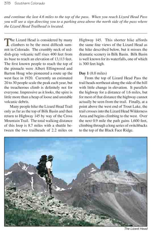
The Lizard Head is considered by many climbers to be the
most difficult summit in Colorado. The crumbly neck of reddish-gray volcanic
tuff rises 400 feet from its base to reach an elevation of 13,113 feet. The
first known people to reach the top of the pinnacle were Albert Ellingwood
and Barton Hoag who pioneered a route up the west face in 1920. Currently an
estimated 20 to 30 people scale the peak each year, but the treacherous
climb is definitely not for everyone. Impressive as it looks, the spire is
little more than a heap of loose and unstable volcanic debris.
Many people hike the Lizard Head Trail only as far as the
top of Bilk Basin and then return to Highway 145 by way of the Cross
Mountain Trail. The total walking distance of this loop is 8.7 miles with a
shuttle between the two trailheads of 2.2 miles on Highway 145. This shorter
hike affords the same fine views of the Lizard Head as the hike described
below, but it misses the dramatic scenery in Bilk Basin. Bilk Basin is well
known for its waterfalls, one of which is 300 feet high.
Day 1 (8.0 miles)
From the top of Lizard Head Pass the trail heads
northeast along the side of the hill with little change in elevation. It
parallels the highway for a distance of 1.6 miles, but for most of that
distance the highway cannot actually be seen from the trail. Finally, at a
point above the west end of Trout Lake, the trail crosses into the Lizard
Head Wilderness Area and begins climbing to the west. Over the next 0.9 mile
the path gains 1,600 feet, climbing through a long series of switchbacks to
the top of the Black Face Ridge.
Once you reach the top of the ridge most of the elevation
gain for this hike is behind you. The trail then ambles along the crest of
the ridge in a westerly direction with terrific views of the Lizard Head in
front of you and Lizard Head Meadows below. The easy walking lasts for about
an hour, then as you approach the western side of Black Face Ridge the trail
turns to the northwest and begins climbing again. You must gain another 500
feet before reaching the highest point on the trail just 500 yards south of
the Lizard Head.
As you pass the south side of Lizard Head you will also
see the junction with the Cross Mountain Trail. Bear right here, and soon
the path begins turning north for the descent into the upper part of Bilk
Basin. The trail finally reaches the bottom of the drainage 1.1 miles later
and promptly crosses to the west side of Bilk Creek.
There is a confusing fork in the trail on the west side
of Bilk Creek where you should bear right, and from there the trail contours
along the west side of the basin for a distance of 0.8 mile until it comes
to another fast-flowing stream. By the time it reaches the second drainage
the trail is 600 feet above Bilk Creek, and the water from the side stream
tumbles noisily down across the trail on its restless journey to the valley
below. High above the left side of the trail are Mount Wilson and Wilson
Peak, two stately fourteeners that seem to have been placed there just to
keep watch over the picturesque scene.
By this time you may have noticed that this part of the
trail is actually an old jeep road. The road was once used to access several
mines above Bilk Basin on the eastern slopes of Wilson Peak. The mines have
long been abandoned and the road is now impassable to any kind of wheeled
vehicles, but it still makes a useful trail. It is used occasionally by
hikers wishing to cross the ridge between Bilk Basin and Navajo Basin (page
372). There is also a small unnamed lake beside the old road 0.5 mile above
the Lizard Head Trail. The lake is not visible from the trail, but you can
reach it by continuing up the road to a small hanging valley 420 feet above
the trail.
Immediately after the old jeep road crosses the cascading
stream below Wilson Peak you will see a more primitive trail descending
through the bushes to the valley below. This is the continuation of the
Lizard Head Trail, and you should turn right here. After loosing 500 feet of
elevation you will be in a grassy meadow on the west side of the basin. This
is a popular overnight stop for backpackers, and there are several good
campsites nearby.
Day 2 (3.2 miles)
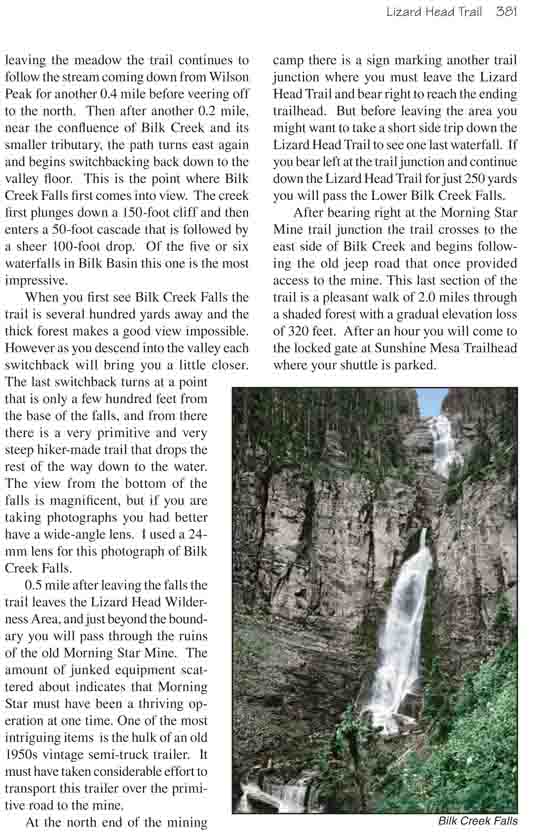
The next item of interest on this hike is the spectacular
Bilk Creek Falls. After leaving the meadow the trail continues to follow the
stream coming down from Wilson Peak for another 0.4 mile before veering off
to the north. Then after another 0.2 mile, near the confluence of Bilk Creek
and its smaller tributary, the path turns east again and begins
switchbacking back down to the valley floor. This is the point where Bilk
Creek Falls first comes into view. The creek first plunges down a 150-foot
cliff and then enters a 50-foot cascade that is followed by a sheer 100-foot
drop. Of the five or six waterfalls in Bilk Basin this one is the most
impressive.
When you first see Bilk Creek Falls the trail is several
hundred yards away and the thick forest makes a good view impossible.
However as you descend into the valley each switchback will bring you a
little closer. The last switchback turns at a point that is only a few
hundred feet from the base of the falls, and from there there is a very
primitive and very steep hiker-made trail that drops the rest of the way
down to the water. The view from the bottom of the falls is magnificent, but
if you are taking photographs you had better have a wide-angle lens. I used
a 24-mm lens for this photograph of Bilk Creek Falls.
0.5 mile after leaving the falls the trail leaves the
Lizard Head Wilderness Area, and just beyond the boundary you will pass
through the ruins of the old Morning Star Mine. The amount of junked
equipment scattered about indicates that Morning Star must have been a
thriving operation at one time. One of the most intriguing items is the hulk
of an old 1950s vintage semi-truck trailer. It must have taken considerable
effort to transport this trailer over the primitive road to the mine.
At the north end of the mining camp there is a sign
marking another trail junction where you must leave the Lizard Head Trail
and bear right to reach the ending trailhead. But before leaving the area
you might want to take a short side trip down the Lizard Head Trail to see
one last waterfall. If you bear left at the trail junction and continue down
the Lizard Head Trail for just 250 yards you will pass the Lower Bilk Creek
Falls.
After bearing right at the Morning Star Mine trail
junction the trail crosses to the east side of Bilk Creek and begins
following the old jeep road that once provided access to the mine. This last
section of the trail is a pleasant walk of 2.0 miles through a shaded forest
with a gradual elevation loss of 320 feet. After an hour you will come to
the locked gate at Sunshine Mesa Trailhead where your shuttle is parked.