Hikers are often surprised when they first see the Flat
Top Mountains of northern Colorado. Most of the state’s other prominent
mountain ranges are crowned with rugged peaks of Precambrian granite, gneiss
and schist. In contrast, the crest of the Flat Tops runs across an enormous
plateau of flat basaltic lava. The vast tableland occupies an area of about
500 square miles, with a large fraction of it being above timberline. The
ancient lava flow that covered the Flat Tops was laid down over the top of
an older sedimentary formation, and today the boundaries of the lava are
often defined by steeply eroded cliffs of rusty red shale and alluvium.
This loop hike follows a trail along the base of the
alluvium cliffs, visiting a series of lakes on the northern side of the Flat
Tops, and then returns along the top of the plateau. It also includes a bit
of adventure near the end where the route crosses a knife-edge ridge between
two parts of the plateau in order to complete the loop. This section of the
trail, called the Devils Causeway, is at one point only 4 feet wide with a
400-foot cliff on either side. The narrowest part of the Causeway is only 20
feet long, however, and most people cross it without too much difficulty (I
have even seen dogs walking across it). But if you suffer from excessive
vertigo you should avoid this hike.
Day 1 (5.5 miles)
The first 0.6 mile of the trail parallels the north shore
of the Stillwater Reservoir. As the trail approaches the west side of the
reservoir you will see a junction with a sign marking the East Fork Trail.
Turn right here. The East Fork Trail then starts a gradual climb away from
the reservoir, arriving at Little Causeway Lake about a half-hour later.
Beyond Little Causeway Lake the terrain becomes much
steeper as the trail climbs into a small basin 250 feet above the lake.
Then, after a brief interlude of level ground, the path goes up the last 400
feet to the top of an 11,580-foot pass. The trail splits at the top of this
pass with the left fork proceeding up to Devils Causeway and the right fork
dropping below the Flat Tops to the Lost Lakes. For now you should bear to
the right. You will be coming down the trail from Devils Causeway on the
return half of this hike.
Before leaving your vantage point at the summit of the
pass you should stop to examine the route ahead. For the next eight miles
you will be walking below a long succession of reddish-brown cliffs that
define the northern side of the Chinese Wall. When you reach the western end
of the Wall the trail will turn south and climb to the top of the Flat Tops
before doubling back to the southern end of the Devils Causeway.
An hour and a half after leaving the pass below Devils
Causeway the trail passes the east side of Causeway Lake, and unless you got
a very early start I suggest you spend the night here. Causeway is quite a
pretty lake, the fishing is good, and there are plenty of excellent
campsites. If you are interested in fishing, pay particular attention to the
outlet on the north end of the lake. This is a spawning area for the lake’s
cutthroat trout, and you can often see 15-inch fish lazing along the bottom
of the shallow, fast-flowing stream. Unfortunately they don’t often take
bait while they are spawning.
Day 2 (5.6 miles)
From Causeway Lake the trail winds lazily through the
dense conifer forest past five more lakes before reaching West Lost Lake,
the next recommended campsite. Round Lake, the next lake you will encounter,
is located about 45 minutes from Causeway Lake. You will also see a trail
junction here where you must bear left. Soon after leaving Round Lake you
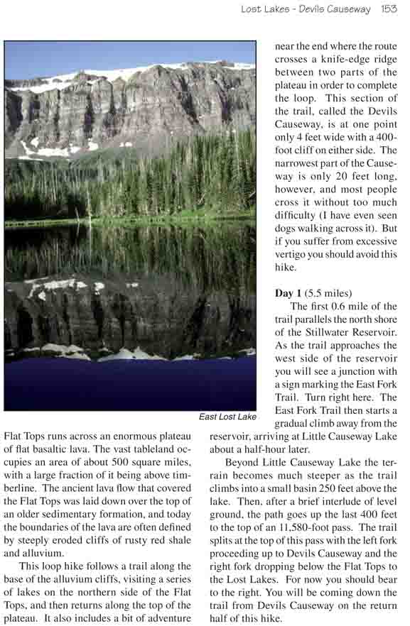
will see Long Lake, then, after another 2.0 miles, East Lost Lake. East Lost
Lake is, in my opinion, the prettiest lake you will see on this hike. It is
especially scenic early in the morning when the mirror-smooth water reflects
the sun-drenched cliffs behind it. There is also a fine campsite near its
western end. I have done this loop in the past as an overnighter, camping at
East Lost Lake instead of Causeway and West Lost Lakes. This is a tiring
trip, however, with 12.7 miles on the second day and little time to enjoy
the scenic beauty of the area.
In the next 0.6 mile after East Lost Lake you will pass
two more trail junctions, where two other trails lead north past a nearby
unnamed lake. Bear left in both cases. Then, after another ten minutes you
will pass a third trail taking off to the south. This is the 0.3-mile-long
spur that leads to Deep Lake. Deep Lake is also quite a pretty lake, and if
you have the time you should definitely see it. There are no signs to mark
the trail, but the junction is easy to spot. You will see the spur heading
abruptly upward from the main trail near the bottom of a small drainage
about 25 minutes after leaving East Lost Lake.
West Lost Lake, the recommended campsite for the second
night, is just 15 minutes beyond the spur to Deep Lake. If it is still early
in the day you may want to continue on, but it is better to resist this
temptation because there are no other good campsites beyond West Long Lake.
Better to spend the night here and get a good rest for the 11.2-mile walk
back to the trailhead tomorrow. You will find some good campsites on the
southwest side of the lake.
Day 3 (11.2 miles)
The third day of this hike is the most tiring; you still
have an 11.2-mile walk across the Flat Tops ahead of you to complete the
loop. Unfortunately, unless you spend a night above timberline, there is
really no way to break up the trip. But although this portion of the hike is
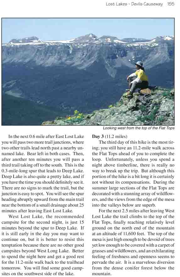
a bit long it is certainly not without its compensations. During the summer
large sections of the Flat Tops are decorated with a stunning array of
wildflowers, and the views from the edge of the mesa into the valleys below
are superb.
For the next 2.5 miles after leaving West Lost Lake the
trail climbs to the top of the Flat Tops, finally reaching relatively level
ground on the north end of the mountain at an altitude of 11,600 feet. The
top of the mesa is just high enough to be devoid of trees yet low enough to
be covered with a carpet of grasses and wildflowers, and an exhilarating
feeling of freshness and openness seems to pervade the air. It is a
marvelous diversion from the dense conifer forest below the mountain.
Soon after reaching the top of the Flat Tops the trail
begins to grow faint, and the presence of many sheep trails on the tundra
also adds confusion. Unfortunately, sheep are allowed to graze in the
wilderness area in the summer and parts of the fragile tundra have been
seriously degraded by their presence. Just remember to stay on the north, or
highest side of the plateau, and don’t be tempted to follow any trail that
goes south more than a few hundred yards from the crest of the mesa. Most of
the sheep trails lead to the lower southern side where there is more water.
As you proceed, pause occasionally to look down from the top of the cliffs
and enjoy the fine views of the Chinese Wall and the Lost Lakes below.
After you have walked about 3.0 miles along the top of
the mesa you will begin to notice a series of widely spaced poles and
monuments that have been erected by the Forest Service to mark the trail.
The Forest Service route, however, veers away from the crest of the Flat
Tops, and it is more interesting to continue walking nearer the rim. Either
way, you will eventually run into the well-used trail leading to Devils
Causeway. When you reach this trail turn left, and after about 20 minutes
you will see the unique formation.
The Devils Causeway is actually a thin strip of land that
forms a bridge between two of the Flat Tops mesas. At its narrowest point
the bridge is only four feet wide. There is an almost sheer drop of 400 feet
on either side, and for some people walking across the Causeway can be an
unnerving experience. The total length of the span is about 200 feet, and no
technical skill is required to make the traverse. Were it not for the
exposure it would be an easy walk-just watch your footing and don’t stop to
look over the edge. If you are absolutely terrified of heights you can
always get down on all fours and crawl across. The really narrow part is
only 20 feet long.
On the north side of Devils Causeway the trail drops down 200 feet to the
top of the pass between Causeway and Little Causeway Lakes, and from there
you must retrace your footsteps for 2.8 miles back to Stillwater Reservoir
and the trailhead.