The Maroon Bells-Snowmass Wilderness Area is one of
Colorado's oldest wilderness areas, and in the 45 years since its creation
it has also become one of the state's most popular outdoor recreational
destinations. Tens of thousands of visitors flock to Maroon Lake every
summer to see the famous Maroon Bells Peaks, and thousands more feel
compelled to walk the tails into the heart of the Elk Mountains. If you are
looking for solitude this isn't where you should be, but if you seek
inspiration this is definitely your hike. There are a few scenes along this
trail, especially on the first day, that are guaranteed to make your blood
run a little faster.
Day 1 (8.5 miles)
As you begin this hike your eyes will invariably be drawn
to two purplish, bell-shaped peaks that rise about three miles southwest of
the lake. These are the famous Maroon Bells: Maroon Peak (14,156 ft.) on the
left and North Maroon Peak (14,014 ft.) slightly in front of it on the
right. If you are fortunate enough to be starting out in the early morning
calm of a clear day you will also see a reflection of the Bells in the
smooth, shaded water of Maroon Lake. This composition has stirred the hearts
of many an artist over the years, and as a result the Maroon Bells are now
among the most photographed mountains in Colorado.
As the trail proceeds along the north shore of Maroon
Lake you will soon see a large pile of wood protruding from the water about
20 feet from the shore. This is an old beaver lodge. There are beaver in the
lake, although they are not often seen. After 0.4 mile the trail leaves the
western end of Maroon Lake and begins climbing up the valley towards Crater
Lake. For the next half hour the Maroon Bells will continue to be directly
in front of you and rarely out of sight.
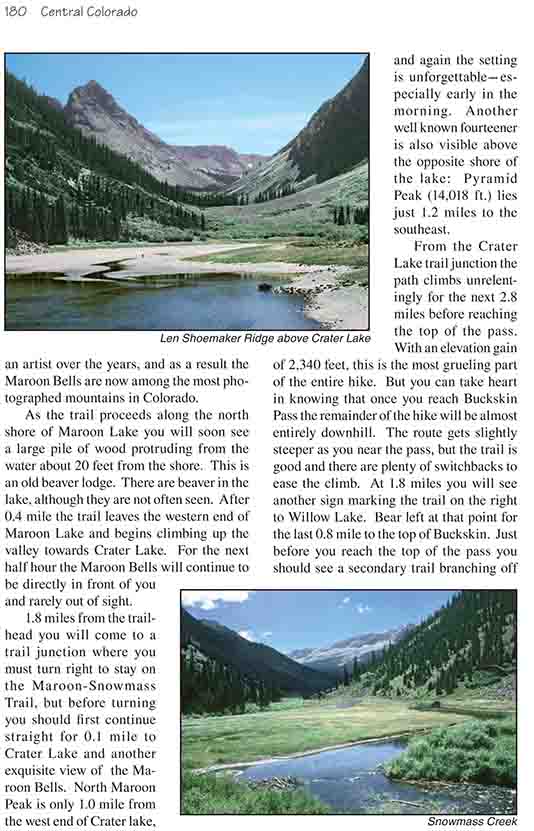
1.8 miles from the trailhead you will come to a trail
junction where you must turn right to stay on the Maroon-Snowmass Trail, but
before turning you should first continue straight for 0.1 mile to Crater
Lake and another exquisite view of the Maroon Bells. North Maroon Peak is
only 1.0 mile from the west end of Crater lake, and again the setting is
unforgettable-especially early in the morning. Another well known fourteener
is also visible above the opposite shore of the lake: Pyramid Peak (14,018
ft.) lies just 1.2 miles to the southeast.
From the Crater Lake trail junction the path climbs
unrelentingly for the next 2.8 miles before reaching the top of the pass.
With an elevation gain of 2,340 feet, this is the most grueling part of the
entire hike. But you can take heart in knowing that once you reach Buckskin
Pass the remainder of the hike will be almost entirely downhill. The route
gets slightly steeper as you near the pass, but the trail is good and there
are plenty of switchbacks to ease the climb. At 1.8 miles you will see
another sign marking the trail on the right to Willow Lake. Bear left at
that point for the last 0.8 mile to the top of Buckskin. Just before you
reach the top of the pass you should see a secondary trail branching off to
the right. If you stay on the main trail at this point you will climb much
higher up the south side of the pass than is needed. Take the secondary
trail and climb the last 20 feet to the lowest point on the pass.
The view from Buckskin Pass is outstanding. Snowmass
Lake, your destination for the day, is clearly visible 2.5 miles west of the
pass, with the mighty Snowmass Mountain (14,092 ft.) rising behind it. You
can also see the permanent snowfield that gave the mountain its name from
this angle. North Maroon Peak is clearly visible from the top of the pass,
but Maroon Peak is hidden behind its northern neighbor.
On the west side of Buckskin Pass the trail starts down
again, dropping gently over the alpine tundra until it encounters a sparse
forest of Engelmann spruce and subalpine fir and, finally, Snowmass Creek.
The route parallels the creek for 300 yards before descending into the lower
forest for the last 1.3 miles to Snowmass Lake.
Snowmass Lake is an extremely scenic place to spend the
night. The lake is 400 yards wide and nearly three-quarters of a mile
long-huge compared to other lakes at this elevation. And, in spite of the
popularity of the lake, it is pristine. The water is clear, the shores are
clean, and the vegetation is in fairly good condition. The majestic Snowmass
Peak (not to be confused with Snowmass Mountain), a 13,600 ft. extension of
Hagerman Peak, rises from its western shore, and a 300-foot high cliff
plunges into the water on its northern side. It would be interesting to know
how deep the lake is below the cliff. There are some very nice camp sites on
the eastern side of the lake, but unfortunately they are often filled. On
weekends during the summer there can literally be hundreds of people looking
for a place to camp at Snowmass. If you can't find a spot, or if you have a
large group, I suggest you find a campsite back down the trail a short way
toward Buckskin Pass.
Day 2 (8.4 miles)
The second day of this hike, while not as scenic as the
first day, is nevertheless a very pleasant walk along a fast-flowing creek
with little or no elevation gain. After leaving Snowmass Lake the trail
proceeds downhill for 1.6 miles before leveling out in a flat marshy area
beside Snowmass Creek. The trail continues down the west side of the
drainage until it comes to a large log jam that has dammed up the stream to
form a wide, shallow pond. This log jam is locally known as the Beaver Dam,
although to me it doesn't look like the work of beavers. In any case you
must cross the stream at this point, walking across the lose logs to the
eastern side.
For the next 5.8 miles the trail winds uneventfully along
the western side of Snowmass Creek. Most of the time the trail is immersed
in a dense forest of spruce, subalpine fir, and aspen, but on occasion the
forest opens up to provide views of the valley or the mountains beyond. A
particularly notable clearing occurs about 1.7 miles below the Beaver Dam
where there is a fine panorama of Copper Creek Valley and Capital Peak
(14,130 ft.), 3.7 miles away.
The maps indicate that there are three large lakes, the
Pierre Lakes, in the upper reaches of the nearby Bear Creek drainage. These
lakes are only 4.0 miles up Bear Creek from the confluence with Snowmass
Creek, but unfortunately there is no trail. Getting to the lakes would
involve 3100 feet of elevation gain and a lot of difficult uphill
bushwacking. I have never talked to anyone who has seen the lakes, but they
certainly look intriguing on the maps. The largest one is almost the size of
Snowmass Lake. It lies in a large, flat bowl at an elevation of 12,180 feet,
about a mile east of Capital Peak. It must be beautiful in its isolation.
The trail finally ends at the entrance to the Snowmass Falls Ranch. The
last mile or so of the route crosses a portion of the ranch, and you will
pass through two unlocked gates at the ranch boundaries. Be sure to close
the gates as you cross into the private land. The Snowmass Falls Ranch also
provides horseback tours to Snowmass Lake, and you will probably see a few
horses along this part of the trail.