The Monument Canyon Trail is one of many trails that were
built in the early 1900s by John Otto, a humble, soft-spoken, some would say
eccentric man who once lived in what is now Colorado National Monument. Otto
was a recluse who preferred to live alone, often seeming to enjoy the
company of his horse more than any human being. Yet in spite of his quaint
lifestyle his activism and his passion for the land eventually brought him
widespread fame and recognition. Today John Otto is fondly remembered as the
founder of Colorado National Monument, and we should be eternally grateful
for what he gave us. Had it not been for Otto’s efforts it is doubtful that
the ruggedly beautiful Colorado National Monument would still retain the
unspoiled natural grandeur it possessed at the turn of the century.
Otto first saw the redrock canyons south of the Grand
Valley 1906. The following year he wrote "I came here last year and found
these canyons, and they felt like the heart of the world to me. I’m going to
stay…and promote this place." Stay he did, and for the next four years he
undertook a one-man campaign to have the area set aside as a national park.
He wrote letters to the local newspapers, he organized fund raising
activities, he wrote letters to government officials in Washington, and he
single-handedly built miles of tortuous trails through the canyons so that
others could appreciate their beauty. Otto’s enthusiasm was contagious. Soon
others began to join him in his effort, and the politicians in Washington
were deluged with letters and petitions supporting his proposal. Finally on
May 24, 1911, President Taft signed a proclamation that made Colorado
National Monument a reality, and Otto’s dream was realized. Fittingly, John
Otto was given the job of caretaker of the monument, a job held for 16 years
until he retired in 1927.
From the trailhead on Rimrock Road the trail
immediately begins descending downward through the smooth slickrock of
the Entrada Sandstone Formation into a small side canyon of Monument
Canyon. It winds through a series of short switchbacks for 0.2 mile
before reaching a trail junction at the bottom of the Entrada. From
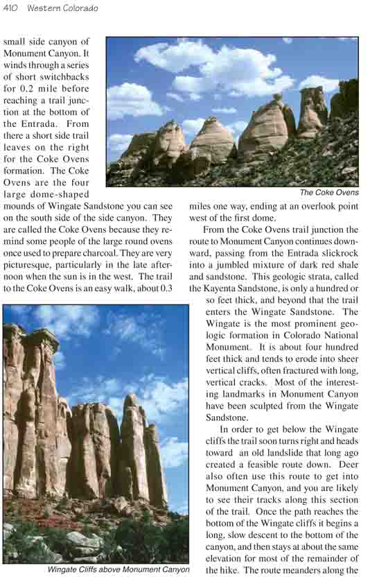
there a short side trail leaves on the right for the Coke Ovens
formation. The Coke Ovens are the four large dome-shaped mounds of
Wingate Sandstone you can see on the south side of the side canyon. They
are called the Coke Ovens because they remind some people of the large
round ovens once used to prepare charcoal. They are very picturesque,
particularly in the late afternoon when the sun is in the west. The
trail to the Coke Ovens is an easy walk, about 0.3 miles one way, ending
at an overlook point west of the first dome.
From the Coke Ovens trail junction the route to
Monument Canyon continues downward, passing from the Entrada slickrock into a jumbled
mixture of dark red shale and sandstone. This geologic strata, called the
Kayenta Sandstone, is only a hundred or so feet thick, and beyond that the
trail enters the Wingate Sandstone. The Wingate is the most prominent
geologic formation in Colorado National Monument. It is about four hundred
feet thick and tends to erode into sheer vertical cliffs, often fractured
with long, vertical cracks. Most of the interesting landmarks in Monument
Canyon have been sculpted from the Wingate Sandstone.
In order to get below the Wingate cliffs the trail soon
turns right and heads toward an old landslide that long ago created a
feasible route down. Deer also often use this route to get into Monument
Canyon, and you are likely to see their tracks along this section of the
trail. Once the path reaches the bottom of the Wingate cliffs it begins a
long, slow descent to the bottom of the canyon, and then stays at about the
same elevation for most of the remainder of the hike. The route meanders
along the base of the cliffs on the west side of the canyon, first in an
easterly direction and then in a northerly direction, for the next three
miles.
This section of the hike is particularly scenic. The
route takes you past a number of interesting spires and thumbs that have
eroded away from the sandstone cliffs into unlikely shapes. The most notable
of these formations is a monolith called the "Kissing Couple". It is a
300-foot-high needle of sandstone that has a vertical split near the top
separating it into two seemingly intertwined columns, like two giant lovers
locked in a timeless embrace. The Kissing Couple is situated 2.2 miles from
the trailhead; its base is just a hundred yards west of the trail.
The cliffs of Monument Canyon are also a favorite hangout
for several species soaring birds, and they are a delight to watch as they
glide effortlessly overhead. There are significant numbers of turkey
vultures, golden eagles, several species of hawks, and even a few peregrine
falcons within the monument boundaries, and if you watch the cliffs as you
walk you should be able to see at least a dozen of these magnificent birds.
All day long they circle lazily along the rim, taking advantage of the
updrafts along the cliffs to hold them aloft as they search for food.
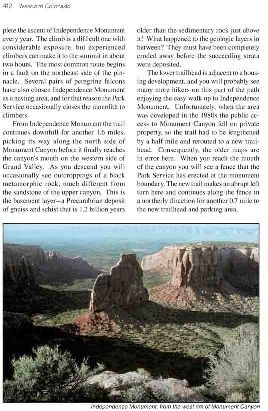
One mile from the Kissing Couple the trail veers eastward
to pass by Independence Monument, a huge, isolated monolith that rises 450
feet above the valley floor. Independence Monument was named by John Otto,
who once celebrated the fourth of July by climbing to the top of the
pinnacle and flying an American flag from its crest. Now several hundred
rock climbers complete the ascent of Independence Monument every year. The
climb is a difficult one with considerable exposure, but experienced
climbers can make it to the summit in about two hours. The most common route
begins in a fault on the northeast side of the pinnacle. Several pairs of
peregrine falcons have also chosen Independence Monument as a nesting area,
and for that reason the Park Service occasionally closes the monolith to
climbers.
From Independence Monument the trail continues downhill
for another 1.6 miles, picking its way along the north side of Monument
Canyon before it finally reaches the canyon’s mouth on the western side of
Grand Valley. As you descend you will occasionally see outcroppings of a
black metamorphic rock, much different from the sandstone of the upper
canyon. This is the basement layer-a Precambrian deposit of gneiss and
schist that is 1.2 billion years older than the sedimentary rock just above
it! What happened to the geologic layers in between? They must have been
completely eroded away before the succeeding strata were deposited.
The lower trailhead is adjacent to a housing development,
and you will probably see many more hikers on this part of the path enjoying
the easy walk up to Independence Monument. Unfortunately, when the area was
developed in the 1980s the public access to Monument Canyon fell on private
property, so the trail had to be lengthened by a half mile and rerouted to a
new trailhead. Consequently, the older maps are in error here. When you
reach the mouth of the canyon you will see a fence that the Park Service has
erected at the monument boundary. The new trail makes an abrupt left turn
here and continues along the fence in a northerly direction for another 0.7
mile to the new trailhead and parking area.