Mount Huron lies 0.6 mile north of the Continental
Divide, at the top of a long ridge that includes Brown's Peak (13,523 ft.).
It is best known for its terrific views of the Three Apostles, three well
known thirteeners that lie directly south of Huron on the Continental
Divide. Ice Mountain, the middle Apostle, is just 52 feet lower than Mount
Huron, and has the reputation among peak baggers of being one of the most
treacherous of the high thirteeners. Mount Huron also provides an
interesting perspective of Ann Lake (page 203), a high hanging lake that
lies just below the northwest side of the Three Apostles.
There are also several notable points of historic
interest along the road to the trailhead. History buffs will certainly want
to stop and spend some time at the old Vicksburg and Winfield mining
settlements. These towns were alive with activity in the 1880s when there
was an explosion of mining activity in Clear Creek Valley north and west of
Huron Peak. There were at least a half-dozen towns in the area, but Winfield
and Vicksburg are the best preserved. Neither town prospered for more than a
few years, but in their heyday they both had hotels, schools, post offices,
and, of course, saloons. Winfield was the largest, with a peak population of
about 1,500 people. 1.7 miles beyond Winfield, or 0.4 miles before the
trailhead the road passes the remains of the old Baker Mine. Baker Mine was
one of the area’s major mines in the 1880s, and there are still a lot of
fallen buildings and mining artifacts scattered nearby.
A good plan is to spend some time checking out these
remnants of Colorado’s colorful past, and then camp at the trailhead the
night before you climb Mount Huron. You will find a beautiful place to camp
beside Clear Creek, just next to the parking area at the end of the road.
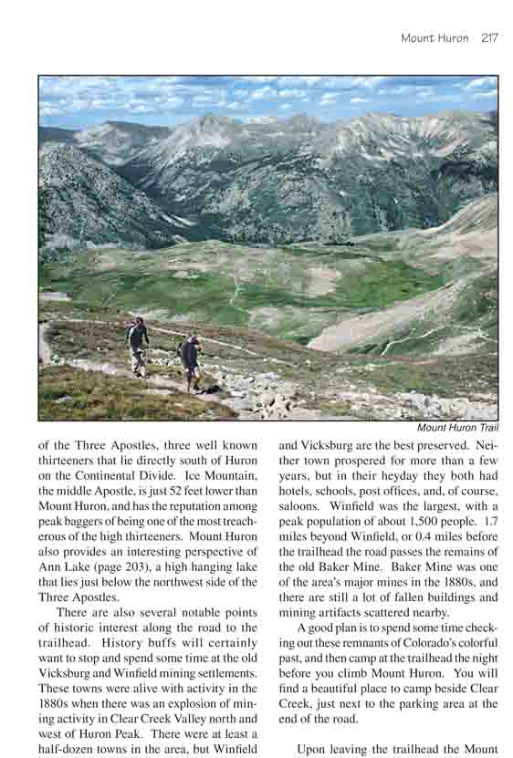
Upon leaving the trailhead the Mount Huron Trail
begins a gradual climb up the eastern side of Clear Creek Valley. After
0.4 mile the grade increases somewhat, then begins a long series of
short switchbacks as it climbs up the slope in an easterly direction.
The trail is in excellent condition, not rocky and not particularly
steep, and it is shaded by a thick forest of spruce and subalpine fir.
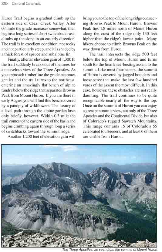
Finally, after an elevation gain of 1,300 ft. the
trail suddenly breaks out of the trees for a marvelous view of the Three
Apostles. As you approach timberline the grade becomes gentler and the
trail turns to the northeast, entering an amazingly flat bench of alpine
tundra below the ridge that separates Browns Peak from Mount Huron. If
you are there in early August you will find this bench covered by a
panoply of wildflowers. The luxury of a level path through the alpine
garden lasts only briefly, however. Within 0.3 mile the trail comes to
the eastern side of the basin and begins climbing again through long a
series of switchbacks toward the summit ridge.
Another 1,200 feet of elevation gain will bring you to
the top of the long ridge connecting Browns Peak to Mount Huron. Browns Peak
lies 1.8 miles north of Mount Huron along the crest of the ridge only 130
feet higher than the ridge’s lowest point. Many hikers choose to climb
Browns Peak on the way down from Huron.
The trail intersects the ridge 500 feet below the top of Mount Huron and
turns south for the final knee-busting assent to the summit. Like most
fourteeners, the summit of Huron is covered by jagged boulders and loose
scree that make the last few hundred yards of the assent the most difficult.
In this case, however, these obstacles are not really daunting. The trail
continues to be quite recognizable nearly all the way to the top. Once on
the summit of Huron you can enjoy a great panoramic view, not only of the
Three Apostles and the Continental Divide, but also of Colorado’s rugged
Sawatch Mountains. This range contains 15 of Colorado’s 55 celebrated
fourteeners, and at least 6 of them are visible from Huron.