Mount Yale is one of fifteen 14,000-foot peaks in
Colorado’s Sawatch Mountain Range. The range is a favorite hiking area,
and writers frequently refer to it with whimsical phrases such as "the
pinnacle of the North American continent", or "the roof of the
Continental Divide". The truth is that this 80-mile-long stretch of
mountains contains more fourteeners than any other range in Colorado,
and all of them, including the three highest peaks in the state, are
relatively easy class-2 climbs. This abundance of climbing opportunities
combined with good trails and plenty of scenic beauty combine to make
the Sawatch Range a favorite among hikers.
Yale is typical of the Sawatch fourteeners. It is a
high, rounded hump with broad sloping shoulders and a rocky,
talus-covered summit. It is one of the well-known Collegiate Peaks that
were surveyed in 1869 by Harvard University Professor J. D. Whitney and
subsequently named after famous universities. Whitney named the highest
peak in his survey Mount Harvard, and he named the one thought to be the
second highest Mount Yale, after his alma mater. Unfortunately for
graduates of Yale it was later discovered that the nearby Mount
Princeton is one foot higher than Mount Yale!
The trail begins by climbing upward toward Browns
Pass through an open forest of lodgepole pine and spruce. The grade is
moderate, but unrelenting. The route follows the west side of Denny
Creek, and although the water is not often visible you can hear the
cascading stream behind the screen of trees to the right of the trail.
After 10 minutes of walking the trail crosses the
boundary into the Collegiate Peaks Wilderness Area, and 20 minutes later
it crosses a log bridge to the east side Denny Creek. 0.3 miles beyond
the bridge you will come to a fork where the trail to Mount Yale
branches off the Browns Pass Trail. As indicated by the Forest Service
sign, you must turn right at the junction.
From the junction the Mount Yale Trail turns abruptly to
the northeast and begins climbing away from Denny Creek. After 15 minutes
the path begins following the left side of a small ravine called Delaney
Gulch. Eventually the trail crosses to the east side of Delaney Creek in the
bottom of the gulch and then begins a long series of switchbacks as it works
its way up through the trees toward timberline.
After gaining about 800 feet of elevation from the Browns
Pass trail junction the path enters a grassy area where most of the trees
were long ago chopped down, and if you watch carefully you will see the
remains of an old broken-down cabin. The structure is just 20 feet from the
right side of the trail, but it is now so deteriorated it is hardly
recognizable as a cabin. If the rotting logs could talk they would probably
tell a story of another lonely prospector whose backbreaking work was never
adequately rewarded.
The trail turns south as it crosses the tree line and
then loops back around to the north for an imposing view of your goal, Mount
Yale. The view from this angle is intimidating, to say the least. The bare,
rocky dome of Yale stands like a giant sleeping monster 2,000 feet above the
trail with long summit ridges spreading out west and southeast of the
mountain. The entire remainder of the route is visible from this
prospective. The trail climbs 1,300 feet in a northerly direction to
intersect the western ridge, and then follows the knife-edge up the last 700
feet to the summit. The climb is not technically difficult, but it is
obvious that a great deal of lung-busting work remains to be done before you
can call the peak your own.
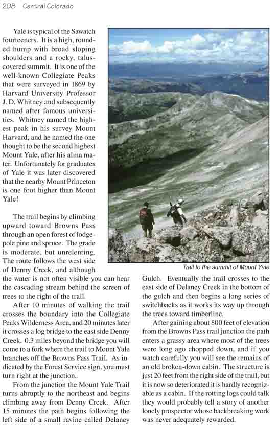
The trail remains reasonably good and the grade
relatively moderate until it nears the base of the summit ridge. Then as it
switchbacks up the side of the ridge it gets progressively steeper and
rockier. When it reaches the top of the ridge the trail disappears
altogether, and for the last 0.6 mile you are left to pick your own way
across the boulders. In some places the easiest route is directly on top of
the ridge, in others it is easier to walk on the right or south side. There
is one false summit that is easiest to avoid by bearing to the right. The
ridge levels out near the end, and the last 100 yards of the climb is an
easy walk.
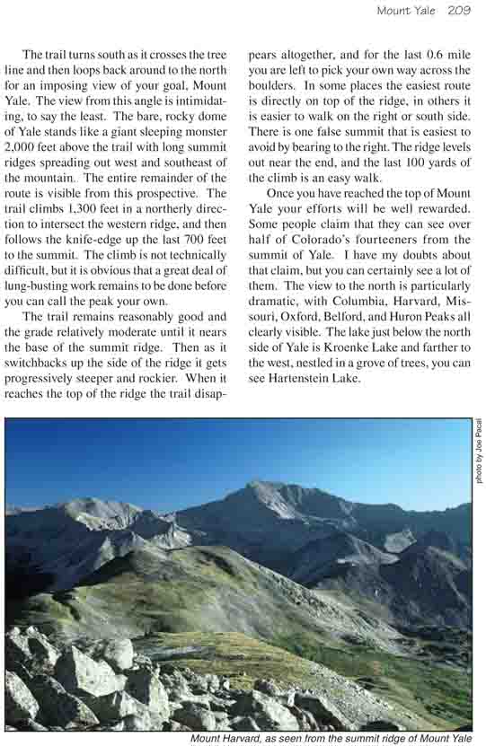
Once you have reached the top of Mount Yale your efforts
will be well rewarded. Some people claim that they can see over half of
Colorado’s fourteeners from the summit of Yale. I have my doubts about that
claim, but you can certainly see a lot of them. The view to the north is
particularly dramatic, with Columbia, Harvard, Missouri, Oxford, Belford,
and Huron Peaks all clearly visible. The lake just below the north side of
Yale is Kroenke Lake and farther to the west, nestled in a grove of trees,
you can see Hartenstein Lake.