Who wouldn’t want to walk to a place with a name like
Music Pass? The pass was given this poetic name because some claim they can
hear musical sounds when the wind blows over the surrounding mountains. I
have not personally experienced that sensation, but I can attest to the
magnificent mountain scenery that surrounds Music Pass and the Sand Creek
Lakes. Even if you miss the legendary music, the hike across Music Pass to
the lakes below can be a memorable endeavor.
Many years ago it was possible to drive a 4WD vehicle all
the way from the Grape Creek Trailhead to the summit of Music Pass, but that
is no longer possible. Motor vehicles are still allowed on the first 2.9
miles of the road, as far as the Music Pass Trailhead, but the final 1.4
miles of the old Music Pass Road have long since been blocked off and
converted to a foot path. From the looks of the trail it has been many years
since it was used by vehicles. There is now little evidence that the trail
was once a road.
The following discussion assumes that you are beginning
your hike at the Music Pass Trailhead, but I must warn you that the last 2.5
miles of the road to this trailhead are extremely steep and rocky and you
won’t make it if you don’t have a 4WD vehicle. If you don’t have a 4WD
vehicle you will have to leave your car at the Grape Creek Trailhead and
walk the last 2.9 miles to the trailhead. You may be lucky enough to get a
ride up in the back of another hiker’s pickup; otherwise you must add
another 5.8 miles onto the round trip walking distance and 1,500 feet to the
elevation gain for this hike. In that case it is probably better to plan the
hike as an overnighter rather than a day hike.
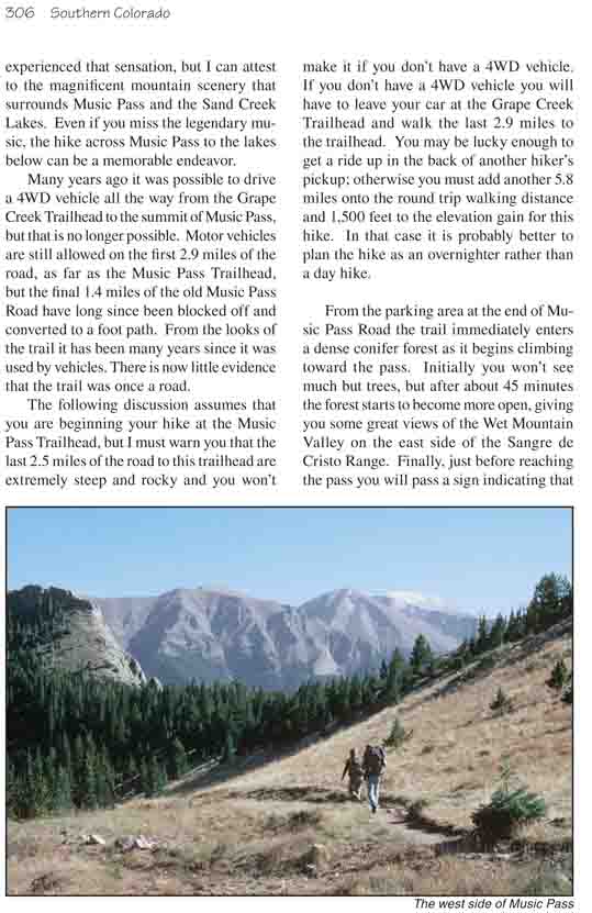
From the parking area at the end of Music Pass Road
the trail immediately enters a dense conifer forest as it begins
climbing toward the pass. Initially you won’t see much but trees, but
after about 45 minutes the forest starts to become more open, giving you
some great views of the Wet Mountain Valley on the east side of the
Sangre de Cristo Range. Finally, just before reaching the pass you will
pass a sign indicating that you are entering the Great Sand Dunes
National Preserve, an extension of the Great Sand Dunes National Park on
the western side of the range. This point also marks the eastern
boundary of the Sangre de Cristo Wilderness Area.
More great views await you at the top of the pass
where the trail begins its descent into Sand Creek Valley. Unfortunately
you won’t be able to see the lakes from this vantage point, but the
vista to the west where the backbone of the mountain is punctuated by
Tijeras Peak (13,604 ft.), Music Mountain (13,356 ft.), and Milwaukee
Peak (13,522 ft.) is sure to give you pause. These three majestic thirteeners lie directly above the
west side of the Sand Creek drainage, and as you press on toward the lakes
they seem to grow ever more imposing.
400 feet below the west side of Music Pass you will come
to a junction where a lesser-used trail branches off to the left and
proceeds downstream along the east side of Sand Creek. Bearing right at the
junction the trail becomes almost level as it follows the 11,000-foot
contour upstream toward the lakes. Then, 0.3 mile beyond the junction with
the lower Sand Creek Trail you will come to another junction where the trail
splits on its way to the Upper and Lower Sand Creek Lakes.
I suggest you turn left at this junction and visit Lower
Sand Creek Lake first, so you can enjoy it before the sun is too high.
Shortly after leaving the junction the path crosses to the west side of the
creek and begins gaining elevation as it makes its way toward the lower
lake. The forest is so dense in this area you can’t see much of the terrain
ahead, but after 30 minutes of relatively easy walking you will suddenly
break out of the trees on the northeast shore of Lower Sand Creek Lake. Here
the sight of Tijeras Peak rising above the opposite side of the lake will
almost knock you off your feet! The towering summit lies less than a
half-mile from the lake shore, and seeing it from this perspective is a view
you will not soon forget. The best time to be there is in the morning while
the sun is in the east, but, impressive as the scene is, it is difficult to
get a good photograph of the mountain and the lake together. Tijeras Peak is
so high and so close you will need a very wide angle lens just to get the
entire mountain in one frame.
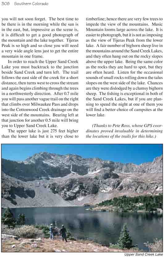
In order to reach the Upper Sand Creek Lake you must
backtrack to the junction beside Sand Creek and turn left. The trail follows
the east side of the creek for a short distance, then turns west to cross
the stream and again begins climbing through the trees in a northwesterly
direction. After 0.7 mile you will pass another vague trail on the right
that climbs over Milwaukee Pass and drops into the Cottonwood Creek drainage
on the west side of the mountains. Bearing left at that junction for another
0.5 mile will bring you to Upper Sand Creek Lake.
The upper lake is just 275 feet higher than the lower
lake but it is very close to timberline; hence there are very few trees to
impede the view of the mountains. Music Mountain looms large across the
lake. It is easier to photograph, but it is not as imposing as the view of
Tijeras Peak from the lower lake. A fair number of bighorn sheep live in the
mountains around the Sand Creek Lakes, and they often hang out on the rocky
slopes above the upper lake. Being the same color as the rocks they are hard
to spot, but they are often heard. Listen for the occasional sounds of small
rocks rolling down the talus slopes on the west side of the lake. Chances
are they were dislodged by a clumsy bighorn sheep. The fishing is
exceptional in both of the Sand Creek Lakes, but if you are planning to
spend the night at one of them you will find a better choice of campsites at
the lower lake.
(Thanks to Pete Ross, whose GPS coordinates proved
invaluable in determining the locations of the trails for this hike.)