Located on the southern flank of the Gore Mountains,
this trail is typical of hiking trails in the area. The route takes you
up into a steep, heavily glaciated valley, through a series of hanging
valleys with stunning scenery, and finally ends at a small lake nestled
against the steep ridge in the center of the range. Although not all of
the valleys have lakes in them, this same basic pattern is repeated
again and again by trails in the Gore Range. With a few exceptions, the
trails all dead-end high in the long glaciated valleys because there is
no practical way out.
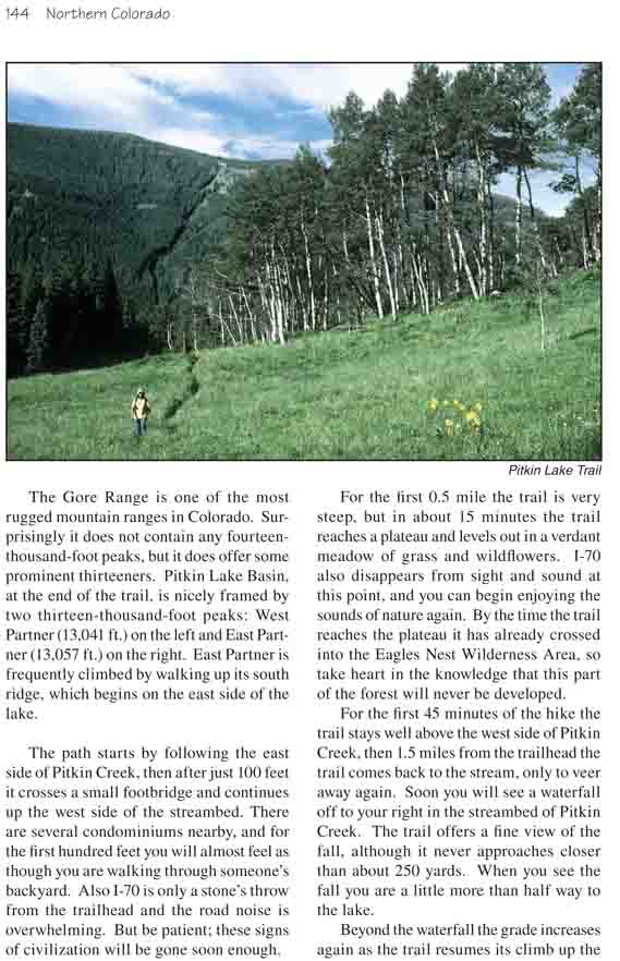
The Gore Range is one of the most rugged mountain
ranges in Colorado. Surprisingly it does not contain any
fourteen-thousand-foot peaks, but it does offer some prominent
thirteeners. Pitkin Lake Basin, at the end of the trail, is nicely
framed by two thirteen-thousand-foot peaks: West Partner (13,041 ft.) on
the left and East Partner (13,057 ft.) on the right. East Partner is
frequently climbed by walking up its south ridge, which begins on the
east side of the lake.
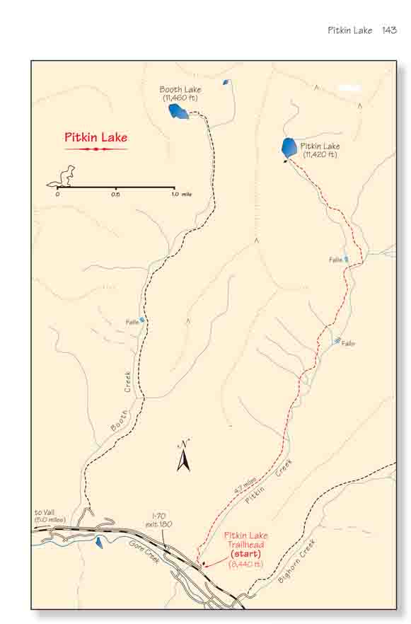
The path starts by following the east side of Pitkin
Creek, then after just 100 feet it crosses a small footbridge and
continues up the west side of the streambed. There are several
condominiums nearby, and for the first hundred feet you will almost feel
as though you are walking through someone’s backyard. Also I-70 is only
a stone’s throw from the trailhead and the road noise is overwhelming.
But be patient; these signs of civilization will be gone soon enough.
For the first 0.5 mile the trail is very steep, but
in about 15 minutes the trail reaches a plateau and levels out in a
verdant meadow of grass and wildflowers. I-70 also disappears from sight
and sound at this point, and you can begin enjoying the sounds of nature
again. By the time the trail reaches the plateau it has already crossed
into the Eagles Nest Wilderness Area, so take heart in the knowledge
that this part of the forest will never be developed.
For the first 45 minutes of the hike the trail stays well
above the west side of Pitkin Creek, then 1.5 miles from the trailhead the
trail comes back to the stream, only to veer away again. Soon you will see a
waterfall off to your right in the streambed of Pitkin Creek. The trail
offers a fine view of the fall, although it never approaches closer than
about 250 yards. When you see the fall you are a little more than half way
to the lake.
Beyond the waterfall the grade increases again as the
trail resumes its climb up the valley. It gains another 400 feet of
elevation before reaching the next a bench, where you must cross a boulder
field at the bottom of an old avalanche chute. Avalanches must be common in
this canyon in the winter; notice the long vertical open areas on the
opposite side of the valley where previous slides have knocked down the
trees.
At 3.3 miles from the trailhead the path turns right and
passes within 200 feet of the bottom of the second waterfall. This is also a
flat area with some good campsites nearby, but for me the noise of the fall
is a bit too intense to consider stopping. The trail crosses Pitkin Creek
just below the waterfall, then stays on the east side of the drainage for
the remainder of the climb.
The last 1.3 miles of the hike are frustrating because of
the false summits. From the second waterfall you will climb a succession of
three more benches, and each time you will probably swear that the lake must
be just above you. But the third time you will be correct.
Pitkin Lake is a small lake, about 600 feet in diameter
and almost perfectly round. It is surrounded on three sides by ridges, with
thirteen-thousand-foot peaks on both the right and left. The lake is well
above timberline so don’t look for trees, but if you are there in August you
won’t be disappointed by the alpine wildflowers. The area is very pristine.
Also, look for the native trout that spawn in the shallow water on the south
side of the lake at the outlet in late summer.