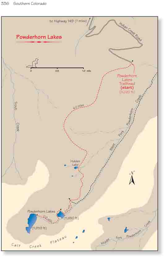
The Powderhorn Lakes are the centerpiece of the
Powderhorn Wilderness Area, a 60,100-acre preserve that in 1993 became
Colorado’s first BLM-managed wilderness. Like the rest of the San Juan
Mountains, the geology of the Powderhorn Wilderness is volcanic, but here
the topography is very different. Instead of the high, rugged peaks normally
associated with the San Juans, the terrain in this area is comprised mostly
of huge, flat mesas topped with treeless meadows that extend for miles
across the alpine tundras. The mesas are the result of a vast amount of
volcanic debris-up to 5,000 feet deep in some places-that was deposited in
the area between 10 and 35 million years ago. The scenic Powderhorn Lakes
are situated in a deep pocket 700 feet below the eastern side of one of the
mesas.
The trail starts out by climbing at a moderate grade in a
westerly direction through a well-shaded forest of Engelmann spruce. One
thing you will immediately notice is the large number of dead trees lying
scattered over the ground like sticks in some giant’s game. It appears that
the trees have been blown down by windstorms that must occasionally roar up
the side of the mountain from the valleys below the trail. Fortunately the
BLM and the Forest Service have done an excellent job of clearing the trail
of fallen trees.
The trail climbs for 1.5 miles before approaching the top
of a hill 850 feet above the trailhead and then drops slightly into a large
alpine meadow. The lush meadow would appear to be an ideal habitat for elk.
It is anywhere from 200 to 500 yards wide and descends gradually down the
southern slopes of the hill toward the West Fork of Powderhorn Creek. The
trail proceeds across the meadow and heads into the trees on its west side.
It then turns south and skirts for a half-mile along the edge of the open
grassy area.
Finally the path leaves the meadow entirely, and after
another half-mile it passes by a 200-foot-diameter pond called Hidden Lake.
This unimpressive lake is not even named on most maps, but it does provide a
recognizable landmark to let you know you are getting close to your
destination. Beyond Hidden Lake the terrain becomes much less uniform. The
trail twists and turns in order to minimize changes in elevation and then,
without any warning, it arrives at the bottom of the green, well-watered
valley that surrounds the West Fork of Powderhorn Creek.
As you approach the creek you will see a sign on the
trail directing you straight ahead to the Powderhorn Lakes. Although it is
not immediately obvious, this sign actually marks the junction between the
Powderhorn Lakes Trail and the East Fork/Middle Fork Trail. The East
Fork/Middle Fork Trail is not well used and you probably won’t even be able
to see it. But if you look directly south from the sign you will see a
5-foot juniper pole planted in the ground about 200 feet away. This pole
marks the beginning of the East Fork/Middle Fork Trail.
The trail continues up the north side of the creek,
avoiding the swampy center of the valley, for another 0.4 mile before
arriving at Lower Powderhorn Lake. Lower Powderhorn, 200 yards across, is
about a third the size of Upper Powderhorn. Like its larger sister lake, it
lies against the base of the cliffs on the south side of the valley. There
are a few nice campsites on the lake’s northern shore, but if you are
interested in spending a night I suggest you camp at the upper lake.
The trail to the upper lake continues to follow closely
along the north side of the creek. Just above the lower lake there are
several large beaver dams, so walk quietly in this area and you may see a
beaver. As you approach the upper lake the trail becomes much less well
defined, and eventually disappears altogether. But this shouldn’t be a
problem; upper Powderhorn Lake fills the entire western end of the valley,
and it is impossible to miss.
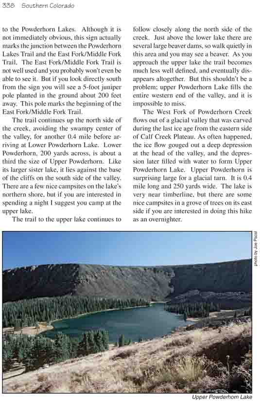
The West Fork of Powderhorn Creek flows out of a glacial valley that was
carved during the last ice age from the eastern side of Calf Creek Plateau.
As often happened, the ice flow gouged out a deep depression at the head of
the valley, and the depression later filled with water to form Upper
Powderhorn Lake. Upper Powderhorn is surprising large for a glacial tarn. It
is 0.4 mile long and 250 yards wide. The lake is very near timberline, but
there are some nice campsites in a grove of trees on its east side if you
are interested in doing this hike as an overnighter.