Your reward at the end of this hike will be a rare
opportunity to lie back and immerse your tired body in a waste-deep pool of
warm spring water on the shore of a scenic, fast-flowing mountain stream.
The spring flows from a small fissure on the east side of the West Fork San
Juan River and tumbles down the rock face into two small pools that have
been constructed by previous hikers. The lower pool, about 20 feet long and
8 feet wide, is situated right on the shore of the river. Its temperature
averages 95 degrees F, but if that is not hot enough you can climb up to the
slightly smaller upper pool. The smaller pool is 15 feet closer to the
spring and 10 degrees hotter. Most people cannot stay in the upper pool for
longer than about 15 minutes, but there is always the option of cooling off
in the 50-degree water of the river.
Although Rainbow Hot Springs is not well known outside
southwestern Colorado it is quite popular among local hikers and you are
unlikely to have the springs all to yourself. Nevertheless it can be a very
enjoyable hike. There are also a number of fine campsites in the open forest
above the springs, and many people do this hike as an overnighter.
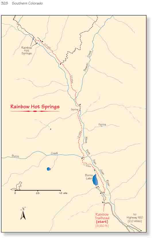
When you leave the parking area you will initially be
walking on a jeep road that runs through an inholding of privately owned
land within San Juan National Forest. Soon you will pass several summer
homes, and after 10 minutes you will come to a well-signed junction
where the Rainbow Trail departs from the right side of the road. The
road actually ends 0.2 miles beyond the junction on the south side of a
large privately-owned lake, but numerous signs make it abundantly clear
that visitors are not welcome at the lake and hikers are expected to
stay on the trail! The residents here could legally close the trail if
they felt that their rights were being abused, so I suggest that we all
comply with the signs and respect their privacy.
Soon after leaving the road the trail turns north and
begins following the rim of West Fork Canyon. The canyon cannot
generally be seen from the trail, but there are a few viewpoints along
the way and it is very impressive. The steep V-shaped gorge has been cut
from a relatively soft strata of volcanic tuff by the cascading river
300 feet below the rim.
0.8 mile after leaving the jeep road the trail finally
leaves the private land and enters San Juan National Forest. Then, 0.2 mile
later you will see a sign indicating that you have entered the Weminuche
Wilderness Area. The forest of huge Douglas fir and Engelmann spruce is so
pretty in this area it is reassuring to know that it will never be
developed.
Within 250 feet after passing the wilderness area sign
the trail comes to the first of three large bridges that have been
constructed by the Forest Service. This one crosses Burro Creek, a tributary
on the west side of the West Fork. From Burro Creek the trail continues high
along the west side of the West Fork of the San Juan River for another 1.2
miles before crossing it on the second bridge. Then just 0.2 mile further it
crosses Beaver Creek on the third bridge.
Before the mid 1980s there were no bridges across West
Fork and Beaver Creek, so it was necessary to ford these rivers in order to
reach the hot springs. Both streams carry a substantial flow of water,
especially in early summer, and wading through the icy, chest-deep water was
often hazardous. Finally, after a backpacker was drowned trying to cross
West Fork, the Forest Service decided to improve the trail and bridges were
constructed across West Fork and Beaver Creek.
After crossing Beaver Creek the trail climbs about 200
feet up the east side of the canyon and continues north. 1.0 mile from
Beaver Creek you will come to a trail junction where the Beaver Creek Trail
heads east towards the Continental Divide. Bear left at this point.
In the next 0.7 mile after leaving the Beaver Creek Trail
Junction the trail crosses two more small drainages. Immediately after the
second drainage you will come to a fork in the trail where you must turn
left, and within 200 feet the path passes through a well-used campsite about
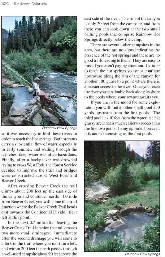
90 feet above the east side of the river. The rim of the canyon is only 20
feet from the campsite, and from there you can look down at the two small
bathing pools that comprise Rainbow Hot Springs directly below the camp.
There are several other campsites in the area, but there
are no signs indicating the presence of the hot springs and there are no
good trails leading to them. They are easy to miss if you aren’t paying
attention. In order to reach the hot springs you must continue northward
along the rim of the canyon for another 100 yards to a point where there is
an easier access to the river. Once you reach the river you can double back
along its shore to the pools where your reward awaits you.
If you are in the mood for some exploration you will find another small
pool 250 yards upstream from the first pools. The third pool lies 10 feet
from the water in a flat grassy area that is much easier to access than the
first two pools. In my opinion, however, it is not as interesting as the
first pools.