The hike described here starts at the Pollock Canyon
Trailhead, but as mentioned above you can also begin at Rattlesnake Arches
Trailhead. Unfortunately a 4WD vehicle is required to reach Rattlesnake
Arches Trailhead, but if this is not a problem I suggest you begin there.
The hike from Rattlesnake Arches Trailhead to all the major points of
interest and back is only 5.2 miles, whereas if you begin at Pollock Canyon
Trailhead your hike will be 12.7 miles long. This is a very hot hike with no
reliable water along the way, and the extra 7.5 miles of walking might be
stretching the limit for some people. The season is also important in
choosing your trailhead. The jeep road to Rattlesnake Arches Trailhead
should not be attempted during winter or early spring, or after a heavy
rain. On the other hand, the hike from Pollock Canyon Trailhead can be very
pleasant during the early spring when the weather is cooler.
The walk in from Pollock Canyon Trailhead passes across
some interesting slickrock country, with beautiful vistas of the Grand
Valley and the Colorado River. But it has to be said that the hike’s major
attraction is the collection of exquisite natural arches that lie along the
eastern rim of Rattlesnake Canyon at end of the trail. They are the best
natural arches to be found anywhere in Colorado.
As you will soon discover, the first 1.6 miles of the
Pollock Canyon Trail is also a mountain bike trail. It really is a great
place to ride mountain bikes, with plenty of challenging slickrock
climbs and nice views of valleys below. The bikes are prohibited from
entering the Black Ridge Canyons Wilderness Area, however, so after the
first 45 minutes the trail is strictly a foot path.
The bike path winds gently upward for the first half
mile, then levels out on the rim of Flume Creek Canyon, a wide,
flat-bottomed canyon bordered by rounded walls of pinkish sandstone. For
the next half mile the trail skirts along the northern rim of the
valley, offering one photographic opportunity after another. The view is
especially scenic early in the morning when the valley is side-lighted
by the eastern sun. Upon reaching the western side of the rim the trail
begins climbing again, moving away from Flume Creek Canyon, and finally
levels out onto a plateau about 400 feet higher that the trailhead. Soon
you see a fork in the trail where one leg of the bicycle path begins a
big loop to the south. Bear right at this point toward the Rattlesnake
Arches. After another 0.3 mile the trail emerges at the upper rim of
Pollock Canyon, where the foot path departs from the bicycle trail. The
foot path is much less distinct than the bike path, so pay attention or
you might miss it. The bicycle path turns left at this point and follows
the rim of the canyon, while the foot path veers off to the right and
immediately begins descending onto Pollock Bench below.
After a very pleasant 15 minute walk across Pollock Bench
you will arrive at the inner rim of Pollock Canyon, where the trail makes a
sudden, steep descent to the dry stream bed below. Once you reach the canyon
floor the trail turns south for 0.4 mile, and then climbs 200 feet up the
other side. This is the most strenuous part of the entire hike, but
fortunately it doesn’t last long. 0.7 mile after leaving Pollock Canyon you
will come to another trail junction, where you must turn left. You are now
on the Old Ute Indian Trail, which once was the traditional route from the
Colorado River to the Rattlesnake Arches. The Pollock Canyon Trail was built
sometime after 1973 so that hikers would not have to cross the private land
on the lower part of the Old Ute Indian Trail.
As you walk southwest on the Old Ute Indian Trail pause
to look up at the horizon. Directly in front of you about a half mile away
you will see a large sandstone formation that looks like the end of a butter
knife protruding upward. A patch of blue sky near the base of the formation
will confirm that you are looking at a natural arch. The trail climbs
another 600 feet over the next 1.2 miles before arriving at another trail
junction with a sign directing you left to the Upper Rattlesnake Arches
trail, or right to the Lower Rattlesnake Arches trail. For reasons that will
become apparent later, I suggest you turn right here onto the lower trail.
At this point you have another half hour of walking to
the first of the Rattlesnake Arches. The trail proceeds along the northern
base of a sandstone mesa for 1.0 mile, then swings around the western end of
the mesa and starts back along its southern side to where the famous arches
are located.
Geologists will immediately recognize the sandstone
cliffs above the trail as a likely place to find arches. The cliffs are
composed of Entrada Sandstone, a strong, homogenous layer of sedimentary
rock that was deposited about 180 million years ago during the Jurassic
Period. The Entrada Formation is uniformly consistent in its composition and
is remarkably free of faults and cracks. It is this characteristic, along
with the fact that it weathers easily, that makes it an ideal building
material for natural arches. A large percentage of the Southwest’s natural
arches occur in the Entrada Sandstone Formation.
The first two arches will come into view soon after the
trail turns east at the end of the mesa. They are located high on the
sandstone cliffs about 100 yards from the end of the mesa. The first arch is
just a small hole, about ten feet across, in the top of a large alcove. 200
feet to the right of the first alcove is another large alcove with a bridge
spanning across the front of it. This arch is actually a double arch, since
there is a small hole in the center of the bridge. Another arch is located
in yet another alcove 200 feet further east. It is partially hidden,
however, and it can’t be seen from the trail.
Most of the arches you will see face southwest; hence
early afternoon is generally the best time to photograph them. There is also
some spectacular scenery on the south side of the trail, opposite the
arches. The deep canyon south of the trail is Rattlesnake Canyon, one of six
major canyons in the Black Ridge Canyons Wilderness Area. Notice the many
alcoves in the Entrada Sandstone on the opposite rim of the gorge. There are
surely many more undocumented natural arches along its southern rim waiting
to be discovered by off-trail hikers.
From the first three arches to the next one is only 0.1
mile, and the rest of the arches can all be found along the following 0.9
mile stretch of trail. In all, there are six especially beautiful arches,
and a few other smaller, harder-to-find ones, all located in the Entrada
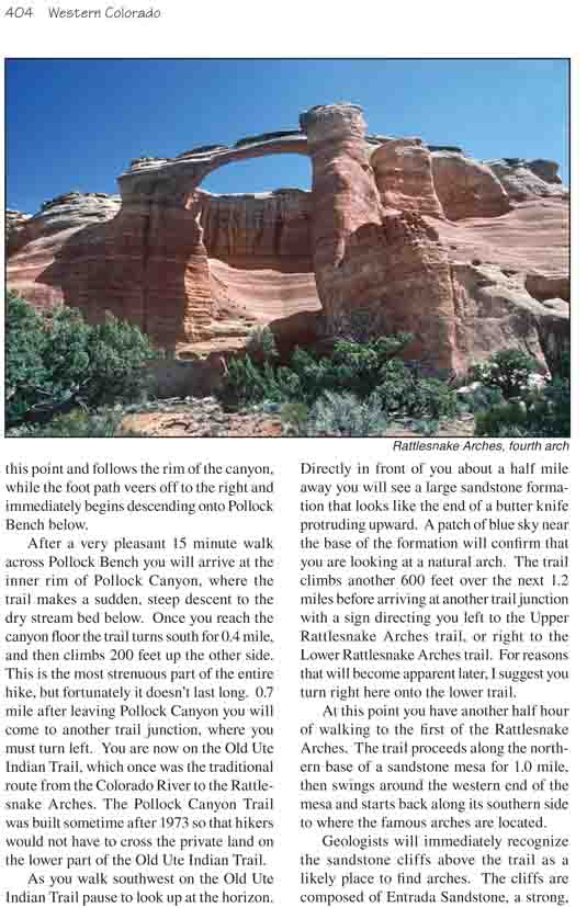
cliffs on the left side of the trail. The fourth arch is extremely slender
and graceful, reminiscent of the Landscape Arch in Utah's Arches National
Park. The fifth one is but a small hole in the top of a high sandstone
alcove-like a chandelier in the top of a grand ballroom-and the sixth arch
forms an almost perfect 80-foot-diameter oval against the blue Colorado sky.
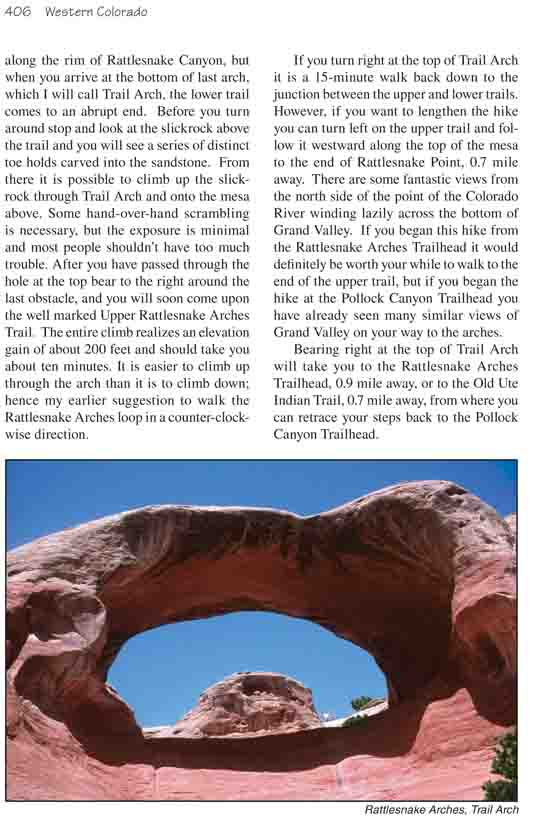
There are undoubtedly more arches along the rim of
Rattlesnake Canyon, but when you arrive at the bottom of last arch, which I
will call Trail Arch, the lower trail comes to an abrupt end. Before you
turn around stop and look at the slickrock above the trail and you will see
a series of distinct toe holds carved into the sandstone. From there it is
possible to climb up the slickrock through Trail Arch and onto the mesa
above. Some hand-over-hand scrambling is necessary, but the exposure is
minimal and most people shouldn’t have too much trouble. After you have
passed through the hole at the top bear to the right around the last
obstacle, and you will soon come upon the well marked Upper Rattlesnake
Arches Trail. The entire climb realizes an elevation gain of about 200 feet
and should take you about ten minutes. It is easier to climb up through the
arch than it is to climb down; hence my earlier suggestion to walk the
Rattlesnake Arches loop in a counter-clockwise direction.
If you turn right at the top of Trail Arch it is a
15-minute walk back down to the junction between the upper and lower trails.
However, if you want to lengthen the hike you can turn left on the upper
trail and follow it westward along the top of the mesa to the end of
Rattlesnake Point, 0.7 mile away. There are some fantastic views from the
north side of the point of the Colorado River winding lazily across the
bottom of Grand Valley. If you began this hike from the Rattlesnake Arches
Trailhead it would definitely be worth your while to walk to the end of the
upper trail, but if you began the hike at the Pollock Canyon Trailhead you
have already seen many similar views of Grand Valley on your way to the
arches.
Bearing right at the top of Trail Arch will take you to the Rattlesnake
Arches Trailhead, 0.9 mile away, or to the Old Ute Indian Trail, 0.7 mile
away, from where you can retrace your steps back to the Pollock Canyon
Trailhead.