|
home page
Links to other sites:
Ordering books & Maps
Comments about this site or our book:
|
The Rawah Wilderness Area has long been recognized as one of Colorado’s special places. A portion of it was classified as a protected area by the Forest Service as far back as 1927, and with the passage of the Wilderness Act in 1964 it became one of America’s very first officially designated wilderness areas. This hike will take you into an area known as the Lakes District that lies in the rugged southern half of the Rawah Wilderness. More than two dozen lakes adorn the eastern slopes of the Medicine Bow Mountains in the Lakes District. The loop hike described here visits no fewer than ten of them, all of which are regularly stocked with brook, rainbow, and cutthroat trout.
Day 1 (7.3 miles)
The trail first heads south along the road for 200 feet, then turns west for a few hundred yards along the north side of a small canal. Soon you will come to a footbridge where the trail crosses the canal and enters the woods in a southerly direction. After a few minutes you will begin to hear the sounds of rushing water as the trail approaches the West Branch of the Laramie River. Then, shortly after passing a spur trail to the Tunnel Campground, the path turns west to follow the north side of the West Branch.
The trail continues to follow the West Branch of the Laramie River for the next 3.1 miles, occasionally approaching the water’s edge but more often staying high above the shore. After 2.1 miles you will come to a junction where the Camp Lake Trail departs from the West Branch Trail. This junction marks the beginning of the Rawah Lakes Loop, and the second half of the hike will be down the Camp Lake Trail to this point. For now, however, you should bear left and continue following the West Branch Trail.
After leaving the Camp Lake Trail junction the terrain becomes noticeably flatter, and the walk through the forest of spruce and subalpine fir is really quite pleasant. Within 0.7 mile the West Branch of the Laramie is joined by the North Fork of the river, and in another 0.3 mile the trail comes to a primitive log bridge across the North Fork. Many a tired backpacker has stopped for the night in this area. There are several fine camping spots nearby, but the area has been heavily impacted and the Forest service discourages camping here.
After crossing the North Fork you will encounter another trail junction where you must bear right. This is where the Rawah Trail leaves the West Branch Trail and continues westward towards the crest of the Medicine Bow Mountains. For about 1.1 miles the Rawah Trail continues along the flat meadow lands beside the North Fork, but then it leaves the creek and climbs 600 feet over the final 0.6 mile to reach the junction with the Twin Crater Lakes Trail.
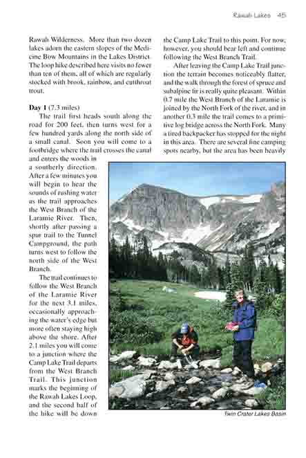
When you reach the Twin Crater Lakes Trail junction I urge you to take a side trip to see them. In my opinion they are the prettiest lakes you will see on this hike, and the valley north of the lakes is an exquisite place to set up camp for the night. 0.3 mile after leaving the Rawah Trail the path enters a beautiful meadow that is almost completely surrounded by granite hills; while you are in this meadow I suggest you choose a camping spot, drop your backpack, and spend the rest of the afternoon checking out the lakes.
The first of the Twin Crater Lakes is 1.3 miles from the trail junction. The trail follows the stream in the bottom of the alpine valley for 0.7 mile, then ascends a low ridge in the back of the valley. The two lakes lie in a small cirque on the other side of the ridge about 200 feet above the lower valley. When you reach the first lake look for a faint trail that circles around its eastern shore to the larger upper lake. Only a thin sliver of land separates the two lakes, and there is only 4 feet of elevation difference between them.
The Twin Crater Lakes are often used as a base for the strenuous climb up South Rawah Peak (12,644 ft.) which lords over the lakes from the northwest. Rockhole Lake is also an occasional destination for extended trips from the Twin Crater Lakes. It is situated 0.5 mile north and 200 feet higher than the lower lakes in another cirque below South Rawah Peak.
Rocky Mountain bighorn sheep are fairly common at these elevations, and when I visited the Twin Crater Lakes in the summer of 2001 I was lucky enough to spot two of them. They seemed as curious about me as I was about them. I followed them for 15 minutes trying to get close enough for a good photograph, but they insisted on keeping their distance. Then when I was leaving the lakes I looked back and there they were. They had circled around to check on me. I stopped and stood still for a few minutes to see what they would do, and they eventually ran past within 15 feet of me.
Day 2 (9.2 miles)
From the Twin Crater Lakes Trail junction the Rawah Trail continues a long, gradual climb up 780 feet over 2.0 miles to the summit of Grassy Pass, a well-named alpine pass that sits right on the edge of timberline. North and South Rawah Peaks rise abruptly to the west, proudly watching over the rolling grasslands of the alpine tundra like proud parents at a children’s park. Although you can’t see it from the trail, Rawah Lake No. 4 lies midway between the two peaks 0.7 mile away and 254 feet higher. A faint, unmarked trail to the lake departs from the main trail about 0.2 mile below the north side of the pass.
The four Rawah Lakes lie along a straight line on the west side of Grassy Pass, and the hike described here passes by three of them. The first lake you can see from the trail is Rawah Lake No. 3. The trail passes above its east side about 15 minutes north of the pass. The trail is situated 120 feet above the lake, but there are two short spur trails that lead down to its shore. When you reach the north end of Lake No. 3 you will come to a junction where you must bear right to see the other Rawah Lakes. The trail descends a short distance down to the bottom of the drainage and follows it northward for another 0.2 mile to Lake No. 2. (If you wish, you can turn south and walk back up the drainage a few hundred yards for a closer look at Lake No. 3.)
Lake No. 2 is only about half the size of Lake No. 3, but it is nevertheless very pretty, with large spruce trees growing right to the water’s edge. Continue along the trail and 200 yards beyond Lake No. 2 you will come to Lake No. 1, which is very similar in size and appearance to Lake No. 2. You will also pass another trail junction where the path to McIntyre Lake branches off to the west.
If you stay on the Rawah Trail for another 1.0 mile beyond the McIntyre Lake Trail you will come to the Camp Lake Trail which will allow you to complete the loop back to the trailhead. However if you do this you will miss three other nearby lakes: Upper and Lower Sandbar Lakes and Big Rainbow Lake. As an alternative, I suggest you cut across country from the north end of Rawah Lake No. 1 to Lower Sandbar Lake and then follow the Sandbar Lakes Trail to the Camp Lake Trail. This route is about 0.7 mile longer, but the three other lakes are worth seeing.
Lower Sandbar Lake is only a ten-minute walk from Rawah Lake No. 1. To get there you should stay on the trail for about 200 yards past the northern end of Rawah Lake No. 1, and then leave the path in an easterly direction. You will have to ford Rawah Creek, but that is no problem. The creek is usually only 6 feet wide. Once you are on the other side of the creek head straight into the forest and begin following the contour of the land around to the southeast. It is easier to walk in the trees above the meadow, but Lower Sandbar Lake is almost exactly the same elevation as Rawah No. 1 so try not to gain too much altitude. If you follow the contour you will make a gradual turn to the right and approach Lower Sandbar while walking southeast. If you bear too much to the east you will run into the stream that drains Lower Sandbar, and if you bear too much to the south you will intersect the trail below the lake. Either way, you can’t really get lost.
Once you reach Lower Sandbar Lake look for the trail on its west side. Follow the trail in a southerly direction and within 0.3 mile you will be on the eastern shore of Upper Sandbar. Both of the Sandbar Lakes are rather shallow; hence they are not the best lakes in the area for fishing. But Upper Sandbar Lake in particular is just the sort of place that moose love, and there is often one of the large animals in the lake. They seem to enjoy lazing about in the tall reeds on the west side, and they don’t appear to have any fear of people.
After leaving Upper Sandbar Lake the trail bends around to the north and arrives at Big Rainbow Lake less than ten minutes later. It then follows the drainage down from the north end of Big Rainbow for another 0.3 mile to the junction with Camp Lake Trail. Once you get on the Camp Lake Trail it will take you about 20 minutes to walk to Camp Lake.
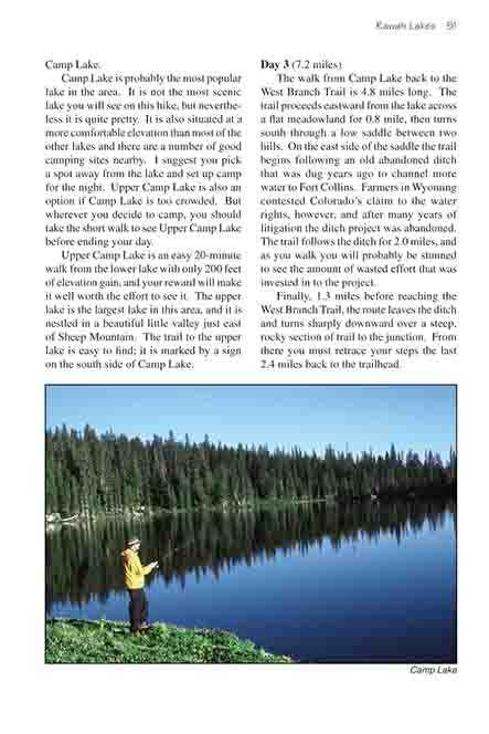
Camp Lake is probably the most popular lake in the area. It is not the most scenic lake you will see on this hike, but nevertheless it is quite pretty. It is also situated at a more comfortable elevation than most of the other lakes and there are a number of good camping sites nearby. I suggest you pick a spot away from the lake and set up camp for the night. Upper Camp Lake is also an option if Camp Lake is too crowded. But wherever you decide to camp, you should take the short walk to see Upper Camp Lake before ending your day.
Upper Camp Lake is an easy 20-minute walk from the lower lake with only 200 feet of elevation gain, and your reward will make it well worth the effort to see it. The upper lake is the largest lake in this area, and it is nestled in a beautiful little valley just east of Sheep Mountain. The trail to the upper lake is easy to find; it is marked by a sign on the south side of Camp Lake.
Day 3 (7.2 miles)
The walk from Camp Lake back to the West Branch Trail is 4.8 miles long. The trail proceeds eastward from the lake across a flat meadowland for 0.8 mile, then turns south through a low saddle between two hills. On the east side of the saddle the trail begins following an old abandoned ditch that was dug years ago to channel more water to Fort Collins. Farmers in Wyoming contested Colorado’s claim to the water rights, however, and after many years of litigation the ditch project was abandoned. The trail follows the ditch for 2.0 miles, and as you walk you will probably be stunned to see the amount of wasted effort that was invested in to the project.
Finally, 1.3 miles before reaching the West Branch Trail, the route leaves the ditch and turns sharply downward over a steep, rocky section of trail to the junction. From there you must retrace your steps the last 2.4 miles back to the trailhead. |