The main attraction of this hike is that it allows you to
bag two of Colorado’s coveted fourteen-thousand-foot peaks in a single day.
True, at 14,001 feet Sunshine is just barely high enough to be classified as
a fourteener, but it is still Colorado’s 55th highest peak, and like Red
Cloud it offers an exquisite panorama of the ruggedly beautiful San Juan
Mountains. The trail up Handies Peak is just across the road from the Silver
Creek Trailhead, and occasionally hikers climb all three of the fourteeners
in a single day. But if this is your plan you had better get an early start
and be prepared for a very long, tiring day. (See page 336 for more
information about the Handies Peak hike.)
For the first 3.0 miles the trail follows the north
side of Silver Creek, occasionally straying as much as 300 yards from
the water but more often staying within a few feet of the shore. Only
after climbing into a large cirque north of Red Cloud Peak where Silver
Creek originates does the trail finally leave the streambed to begin the
climb to the summit ridge. You will probably notice that the first mile
or so of the trail is actually an old, overgrown jeep or wagon road. It
is barely recognizable as a road now, but it was originally built to
service at least two mines above the creek.
As you walk along Silver Creek it will soon become
clear how it got its name. Some sections of the creek have an unusual
silvery blue-gray color that is caused by dissolved minerals
precipitating out of the water. Interestingly, the precipitation is most
pronounced in areas where the creek is joined by smaller side streams.
Apparently the side streams carry a different solution of minerals,
causing a precipitation reaction to occur when waters are mixed.
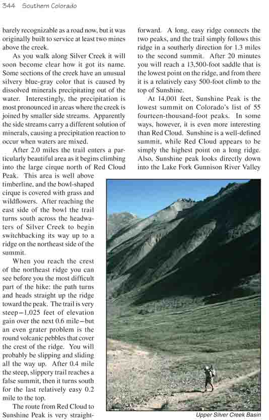
After 2.0 miles the trail enters a particularly beautiful
area as it begins climbing into the large cirque north of Red Cloud Peak.
This area is well above timberline, and the bowl-shaped cirque is covered
with grass and wildflowers. After reaching the east side of the bowl the
trail turns south across the headwaters of Silver Creek to begin
switchbacking its way up to a ridge on the northeast side of the summit.
When you reach the crest of the northeast ridge you can
see before you the most difficult part of the hike: the path turns and heads
straight up the ridge toward the peak. The trail is very steep-1,025 feet of
elevation gain over the next 0.6 mile-but an even grater problem is the
round volcanic pebbles that cover the crest of the ridge. You will probably
be slipping and sliding all the way up. After 0.4 mile the steep, slippery
trail reaches a false summit, then it turns south for the last relatively
easy 0.2 mile to the top.
The route from Red Cloud to Sunshine Peak is very
straightforward. A long, easy ridge connects the two peaks, and the trail
simply follows this ridge in a southerly direction for 1.3 miles to the
second summit. After 20 minutes you will reach a 13,500-foot saddle that is
the lowest point on the ridge, and from there it is a relatively easy
500-foot climb to the top of Sunshine.
At 14,001 feet, Sunshine Peak is the lowest summit on
Colorado’s list of 55 fourteen-thousand-foot peaks. In some ways, however,
it is even more interesting than Red Cloud. Sunshine is a well-defined
summit, while Red Cloud appears to be simply the highest point on a long
ridge. Also, Sunshine peak looks directly down into the Lake Fork Gunnison
River Valley where the trail starts. Both peaks offer fine views of many
other fourteeners in the area, most notably Uncompahgre to the north and
Handies to the west.
For the return portion of this hike many people choose to
take a shortcut route down one of the gullies on the west side of the summit
ridge. I don’t recommend this. The steep western slopes of the two peaks are
covered with loose talus, and it is almost impossible to make the descent
without rolling rocks down on people below. Furthermore, the shortcut is not
really that much shorter-it will get you back to the trailhead only about a
half-hour sooner. The BLM has posted a sign on the summit ridge to
discourage hikers from leaving the trail, and I highly recommend that you
heed their advice. Nevertheless, so many people choose the shortcut route
that I feel I should offer some information about it.
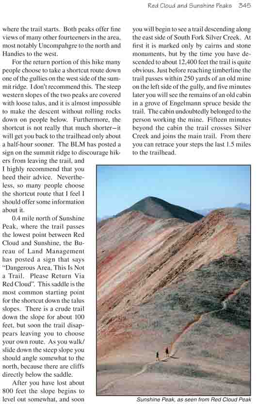
0.4 mile north of Sunshine Peak, where the trail passes
the lowest point between Red Cloud and Sunshine, the Bureau of Land
Management has posted a sign that says "Dangerous Area, This Is Not a Trail.
Please Return Via Red Cloud". This saddle is the most common starting point
for the shortcut down the talus slopes. There is a crude trail down the
slope for about 100 feet, but soon the trail disappears leaving you to
choose your own route. As you walk/slide down the steep slope you should
angle somewhat to the north, because there are cliffs directly below the
saddle.
After you have lost about 800 feet the slope begins to
level out somewhat, and soon you will begin to see a trail descending along
the east side of South Fork Silver Creek. At first it is marked only by
cairns and stone monuments, but by the time you have descended to about
12,400 feet the trail is quite obvious. Just before reaching timberline the
trail passes within 250 yards of an old mine on the left side of the gully,
and five minutes later you will see the remains of an old cabin in a grove
of Engelmann spruce beside the trail. The cabin undoubtedly belonged to the
person working the mine. Fifteen minutes beyond the cabin the trail crosses
Silver Creek and joins the main trail. From there you can retrace your steps
the last 1.5 miles to the trailhead.