Ruybalid Lake is one of several seldom-visited lakes
that dot the top of a large mesa on the west side of the Conejos River.
Although the mesa and its environs comprise the southwestern third of
the rugged San Juan Mountains and the Continental Divide runs along the
west side of the mesa, the terrain here is surprisingly gentle. This
part of the San Juans also receives far fewer visitors than the more
challenging mountains further north, and that, for many, is part of its
attraction.
The wild, remote nature of the South San Juans was
dramatically brought to the public’s attention in the fall of 1979, when a
grizzly bear was killed about 10 miles west of Ruybalid Lake. Until then it
had been almost 30 years since a grizzly had been seen in Colorado. There
have not been any other confirmed grizzly sightings since than, but there is
a great deal of circumstantial evidence that there are still grizzlies
living in the area.
After leaving the parking area the trail winds along the
eastern edge of a horse pasture near the Conejos River for a few hundred
yards, before entering a dense grove of aspen trees. Soon afterward it
crosses the boundary of the South San Juan Wilderness Area and begins
climbing up the west side of the Conejos River Valley. This is the most
strenuous part of the hike. The trail gains 2,100 feet of elevation over the
next 2.5 miles before finally leveling out on the top of the mesa.
Fortunately the grade is not extremely steep, and there are several nice
views of the Conejos Valley along the way.
After 30 minutes of walking you will come to a spur trail
on the left that leads to the Rough Creek Waterfall. The spur is somewhat
primitive and easy to miss, so watch the left side of the trail carefully.
There is a 10-foot, 18-inch-diameter bleached log lying on the left side of
the trail at the junction with the word "Falls" written on it. Also, there
is a small hand-painted sign nailed to a tree, but it is facing the wrong
direction and partially hidden from hikers walking up the trail.
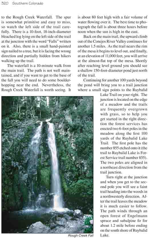
The waterfall is a 10-minute walk from the main trail.
The path is not well maintained, and if you want to get to the base of the
fall you will need to do some boulder-hopping near the end. Nevertheless,
the Rough Creek Waterfall is worth seeing. It is about 80 feet high with a
fair volume of water flowing over it. The best time to photograph the fall
is about three hours before noon when the sun is high in the east.
Back on the main trail, the upward climb out of the
Conejos River Valley continues for another 1.5 miles. As the trail nears the
rim of the mesa it begins to level out, and finally, at an elevation of
11,000 feet, you will arrive at the almost-flat top of the mesa. Shortly
after reaching level ground you should see a shallow 150-foot-diameter pond
just north of the trail.
Continuing for another 100 yards beyond the pond will
bring you to a trail junction where a small sign points to the Ruybalid Lake
Trail on your right. The junction is located on the edge of a meadow and the
trails are frequently overgrown with grass, so to help you get started in
the right direction the forest services has erected two 6-foot poles in the
meadow along the first 100 yards of the Ruybalid Lake Trail. The first pole
has the number 855 etched onto it (the trail to Ruybalid Lake is Forest
Service trail number 855). The two poles are aligned in a northeast
direction from the trail junction.
Turn right at the junction and when you get to the second
pole you will see a faint trail heading into the woods in a northwesterly
direction. After the trail leaves the meadow it is much easier to follow.
The path winds through an open forest of Engelmann spruce and subalpine fir
for about 1.2 mile before ending on the south shore of Ruybalid Lake.
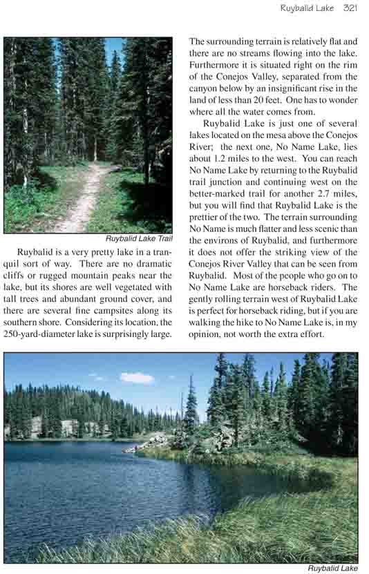
Ruybalid is a very pretty lake in a tranquil sort of way.
There are no dramatic cliffs or rugged mountain peaks near the lake, but its
shores are well vegetated with tall trees and abundant ground cover, and
there are several fine campsites along its southern shore. Considering its
location, the 250-yard-diameter lake is surprisingly large. The surrounding
terrain is relatively flat and there are no streams flowing into the lake.
Furthermore it is situated right on the rim of the Conejos Valley, separated
from the canyon below by an insignificant rise in the land of less than 20
feet. One has to wonder where all the water comes from.
Ruybalid Lake is just one of several lakes located on the
mesa above the Conejos River; the next one, No Name Lake, lies about 1.2
miles to the west. You can reach No Name Lake by returning to the Ruybalid
trail junction and continuing west on the better-marked trail for another
2.7 miles, but you will find that Ruybalid Lake is the prettier of the two.
The terrain surrounding No Name is much flatter and less scenic than the
environs of Ruybalid, and furthermore it does not offer the striking view of
the Conejos River Valley that can be seen from Ruybalid. Most of the people
who go on to No Name Lake are horseback riders. The gently rolling terrain
west of Ruybalid Lake is perfect for horseback riding, but if you are
walking the hike to No Name Lake is, in my opinion, not worth the extra
effort.