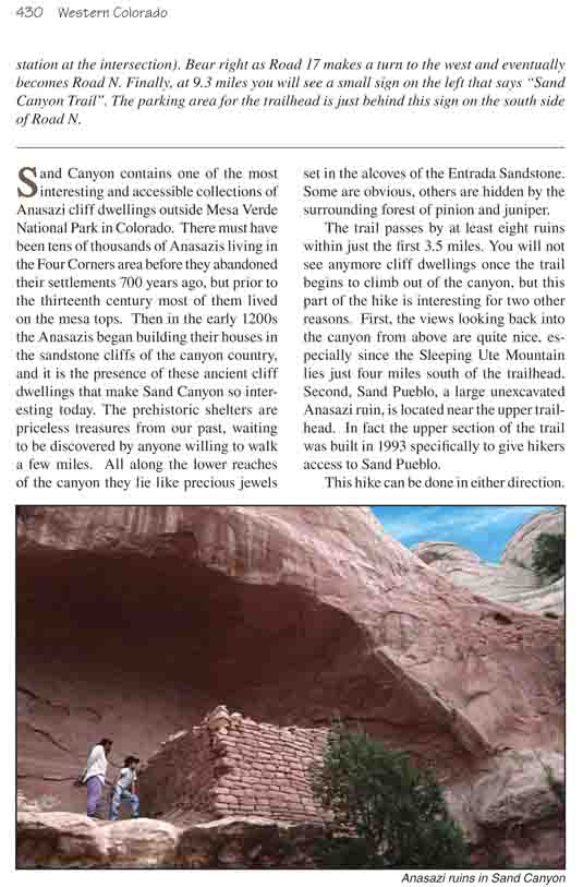
Sand Canyon contains one of the most interesting and
accessible collections of Anasazi cliff dwellings outside Mesa Verde
National Park in Colorado. There must have been tens of thousands of
Anasazis living in the Four Corners area before they abandoned their
settlements 700 years ago, but prior to the thirteenth century most of them
lived on the mesa tops. Then in the early 1200s the Anasazis began building
their houses in the sandstone cliffs of the canyon country, and it is the
presence of these ancient cliff dwellings that make Sand Canyon so
interesting today. The prehistoric shelters are priceless treasures from our
past, waiting to be discovered by anyone willing to walk a few miles. All
along the lower reaches of the canyon they lie like precious jewels set in
the alcoves of the Entrada Sandstone. Some are obvious, others are hidden by
the surrounding forest of pinion and juniper.
The trail passes by at least eight ruins within just the
first 3.5 miles. You will not see anymore cliff dwellings once the trail
begins to climb out of the canyon, but this part of the hike is interesting
for two other reasons. First, the views looking back into the canyon from
above are quite nice, especially since the Sleeping Ute Mountain lies just
four miles south of the trailhead. Second, Sand Pueblo, a large unexcavated Anasazi ruin, is located near the upper
trailhead. In fact the upper section of the trail was built in 1993
specifically to give hikers access to Sand Pueblo.
This hike can be done in either direction. Normally I
would suggest you start at the top to avoid the uphill climb out of Sand
Canyon. But I think in this case it is better to start from the lower
trailhead and walk north. This is because the Anasazis almost always
built their homes in south-facing alcoves where they could catch more of
the winter sunshine, and if you are facing south while you walk you may
miss some of them.
From the trailhead on McElmo Road the trail starts
out by climbing gradually up the slickrock past the west side of a
prominent sandstone outcropping called Castle Rock. After 0.2 mile it
reaches the north side of Castle Rock and begins to swing east toward
Sand Canyon. Before leaving Castle Rock, however, you should walk off
the trail for a short distance to the right and explore the north side
of the outcropping. This area was also inhabited by the Anasazis, and
there is at least one obvious ruin only 150 feet from the trail. Castle
Rock was the location of an archeological excavation in the early 1990s,
but the work is now finished and the site has been restored to its
natural condition.
About twenty minutes from the trailhead the path
levels out and begins following a narrow bench along the base of the
Entrada Sandstone cliffs on your left. It is along this bench that most
of the Anasazi ruins of Sand Canyon are located. Watch the base of the
cliffs as you walk, and within 1.1 miles you will see your first ruin
peering through the pinion and juniper forest. It lies at the end of a
short spur trail, about 100 yards off the main path.
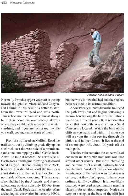
The first ruin contains the stone walls of one room
and the rubble from what was once several other rooms. But most
interesting are the remains of a small, partially buried circular kiva.
We don’t really know what the significance of the kiva was in the
Anasazi culture, but they don’t appear to have been ordinary family
dwellings. It is more likely that they were used as community meeting
places or for religious purposes. Notice the seep, or spring, at the
base of the cliff just to the right of the ruin. This water source was
undoubtedly an important factor in the choice of this particular alcove
by the Indian family that once lived here.
The next ruin, a particularly picturesque one, is
barely 0.1 mile beyond the first one. Notice at this ruin how the
Indians filled in the floor of the alcove behind the retaining wall in
order to level the floor of their dwelling. As the trail meanders
northward the bench gets progressively narrower and narrower. Watch for
other short trails branching off to the rim on the right, where you can
look about 200 feet down into the bottom of the Sand Canyon drainage.
There is seldom running water in Sand Canyon, but the streambed is
almost never completely dry either. The series of springs in the bottom
of the canyon would have provided a reliable source of water for the
many Indians who lived here.
1.9 miles from the trailhead you will come to a junction
where another well used trail comes in from the East Fork of Rock Canyon on
the left. I will say more about this trail later, but for now bear right
toward the bottom of Sand Canyon. Just 0.1 mile beyond the junction, you
will come to point where the path drops about 100 feet into a small side
canyon west of Sand Canyon. Notice the three exquisite cliff dwellings
directly in front of you on the other side of the side canyon. They are
probably the most photogenic of all the ruins you will pass on this hike.
One of them, located in an odd onion-shaped alcove with colorful streaks of
desert varnish, is particularly appealing. After dropping into the side
canyon the trail bends around in front of the ruins and onto a lower bench.
Take the time to climb up into one of the alcoves and you will see an
impressive landscape dominated by the nearby Sleeping Ute Mountain, just as
the original residents of the alcove saw it 700 years ago
Be sure also to watch the other side of the canyon for
ruins as you walk. Another particularly large ruin is clearly visible on the
east side of the canyon 0.4 mile upcanyon from the onion-shaped alcove. On
the west side the path passes by at least two more easily accessible ruin
sites before it reaches the bottom of the Sand Canyon drainage 3.8 miles
from the trailhead. There is a trail junction in the bottom of the drainage
with one trail staying in the bottom of the canyon and the other climbing up
the other side. The trail up on the east side of Sand Canyon passes by three
more ruins before joining a private road that leads back to the McElmo Road.
To reach Sand Pueblo, where your shuttle car is parked,
you must bear left when the trail reaches the streambed and continue walking
northeast along the bottom of the sandy wash. After 0.4 mile you will see a
wooden trail marker, where the trail turns left to begin climbing out of the
canyon. From this point on the trail becomes much steeper, as you must gain
950 feet before reaching the upper trailhead at the top of the mesa. You can
monitor your progress by watching the radio towers on the other side of the
canyon; they are about 200 feet higher in elevation than the upper
trailhead. Most of the route out of the canyon is immersed in a forest of
pinion pine and juniper, but occasionally the forest opens up to a nice view
of Sleeping Ute Mountain with Sand Canyon in the foreground. You may also
hear noises like motors running. Unfortunately there are several carbon
dioxide wells on the east side of the canyon, and the pumps often interrupt
the serenity-reminding us that ownership of Sand Canyon has already passed
from the Anasazis to the white man.
About 1.0 mile after leaving the canyon bottom the
trail starts to level out. Then, after another 0.7 mile it briefly
reenters the upper reaches of Sand Canyon drainage once again before
finally leaving the ravine near the upper trailhead.
Sand Canyon Pueblo
Before leaving the upper Sand Canyon Trailhead be sure to
check out the Sand Canyon Pueblo. It lies at the end of a short, well
marked, 0.1 mile spur trail that departs on the west side of the Sand Canyon
trailhead. This site is currently being excavated by the Crow Canyon
Archeological Center, but the work is progressing very slowly and to the
untrained eye the site looks more like a scattered pile of rocks than an
ancient Indian pueblo. Probably the most impressive thing about the Sand
Canyon Pueblo is its size. The ancient city is spread over an area of about
four acres and contains some 84 kivas. During the late 1200s, at the peak of
the Mesa Verde Anasazi culture, it must have been one of the largest
settlements in the region. More information about the Sand Canyon Pueblo can
be obtained from the Crow Canyon Archeological Center in Cortez at (970)
565-8975.
East Fork Rock Canyon
If it is inconvenient for you to place a shuttle car at
the upper Sand Canyon trailhead you will be interested to know there is
another trail in the lower part of Sand Canyon that can be used as a
connecting trail back to the lower trailhead. This alternative route also
passes by several Anasazi ruins as well as a large natural arch. The total
length of the loop, including a short side trip to see the arch, is 6.4
miles.
After you have walked 1.9 miles from the lower Sand
Canyon trailhead you will come to a trail junction where you must turn left
on a trail leading to the East Fork of Rock Canyon. This trail proceeds in a
northwesterly direction toward a large promontory of Dakota Sandstone that
rises between Sand Canyon and East Fork. The trail rises slightly as it
winds across the intervening layers of shale until it reaches the base of
the sandstone cliffs 1.0 mile later. Near the base of the cliffs the trail
passes just below an old mine that was dug a short distance into a yellowish
deposit of siltstone, probably in search of uranium.
A few hundred yards beyond the mine the trail forks
again. You must take the left fork to return to the trailhead, but first
bear right for short side trip to see the natural arch. The arch is located
at the base of the Dakota Sandstone about 0.4 mile beyond the trail
junction, but you won’t be able to see it until you are almost under it.
After you have walked 0.3 miles you will see a fainter trail leaving on the
right. This trail angles uphill, roughly parallel to the lower trail, to a
point directly under the arch. If you want to get close enough to the arch
to see daylight through it you will have to take this trail. The arch is
about 100 feet across, but it is very close to the cliff. If you want to
photograph it you should plan to be under it in the afternoon, as it is in
the shade earlier in the day.
You can explore further by staying on the lower trail and
continuing on past the arch. The trail arrives at the bottom of East Fork
Rock Canyon after another 0.7 mile, then crosses the bottom of the drainage
and turns south to follow the west side of the canyon. Otherwise, return to
the trail junction near the mine and take the south fork back to the
trailhead.
From the junction the trail immediately drops about 100 feet and proceeds
in a southwesterly direction for 1.1 miles along a bench at the base of the
Entrada Sandstone. This section of the trail is actually an old jeep road,
but it doesn’t appear to have been used in many years. After 1.1 miles the
trail leaves the road and turns southeast, then climbs up to the base of the
Entrada cliffs. Soon you will encounter the first of another four alcoves
containing ruins. Most of them are very well preserved and easy to spot; the
path passes just below them as it meanders along the base of the cliffs.
Finally, 1.1 miles after leaving the jeep road, you will intersect the Sand
Canyon trail again, and from there it is only 0.3 mile back to the
trailhead.