Where else but in Telluride could one ever expect to
find a scenic 13-mile alpine loop trail that begins practically in the
center of town! The Sneffels Highline Trail is a Colorado classic, and
it is a fitting addition to one of the most interesting and picturesque
towns in the state.
Telluride is almost completely surrounded by
mountains, and hiking is a popular summer sport among its residents.
Many of the nearby trails and bike paths follow old mining roads that
were built during the first half of the last century. Some sections of
the Sneffels Highline Trail also follow these older trails, but in 1990
the Forest Service undertook a project to create a loop by connecting
several of the older trails north of the city. The result of the effort
was the Sneffels Highline Trail. The trail was so named because two
miles of the loop lie within the Mount Sneffels Wilderness Area, and it
is hoped that someday this part of the trail will be extended further
into the preserve.
The trail starts out along the east side of Cornet Creek,
but after just 100 feet you will come to a small footbridge that you must
cross to the west side of the stream. (The trail up the east side of the
creek ends at Cornet Falls 0.2 miles away.) After crossing the bridge you
will be on the Jud Wiebe Trail, named after a locally famous forest ranger
who died of cancer in 1986.
As the path climbs along the slopes northwest of
Telluride it passes some great views of the town and the valley below.
Telluride is located in the bottom of a deep glacial valley with an
extraordinarily flat bottom and high mountains on three sides. Many of the
peaks on the north, east, and south sides of the town are over 12,000 feet
high and a few exceed 13,000 feet. The town is an ideal location for a ski
resort, and many sky runs are clearly evident on the slopes across of the
valley. You can also see the gondolas on the Mountain Village tramway
creeping slowly up the side of the mountain, and as you gain altitude the
Mountain Village itself will begin to come into view.
Initially you will be walking through a forest of Douglas
fir, but as the trail climbs higher it enters an aspen forest. After 0.9
mile you will come to a small sign marking the junction where the Mill Creek
Trail departs from the Jud Wiebe Trail. The Mill Creek Trail is one of the
trails that comprise the Sneffels Highline Loop, and you must bear left at
this point. Within two minutes after leaving the Jud Wiebe Trail the path
crosses Butcher Creek and comes to another junction. This is the start of
the Sneffels Highline Loop, and I suggest that you turn right at this point.
Some hikers prefer to bear left at the junction because the uphill portion
of the trail is not quite as steep if the hike is walked in a clockwise
direction. However in my opinion the scenery is slightly better if the loop
is followed in a counterclockwise direction, and that is the route I will
describe here.
Between 1901 and about 1916 there was a large building in
Epees Park, the flat area where the Jud Wiebe and Sneffels Highline Trail
junctions are located. The building was called the "county pest house", and
its purpose was a quarantine facility for victims of pestilence (diphtheria,
scarlet fever, and other contagious diseases). Unfortunately there is no
trace of the building now, but you can still see remnants of an historic
waterline that once carried water through Eppes Park to the town below.
After leaving Epees Park the Sneffels Highline Trail
follows Butcher Creek to its source, 0.6 miles away, and then continues
climbing northward up the steep canyon. After you have climbed about 1,500
feet from the junction the trail passes a notch in the ridge between Butcher
Creek Canyon and Lower Mill Creek Basin where you can enjoy a fine view of
the rugged country that surrounds Mill Creek. The return part of the loop
crosses the western side of Lower Mill Creek Basin, but the trail is well
hidden below the dense forest and can’t be seen from the notch.
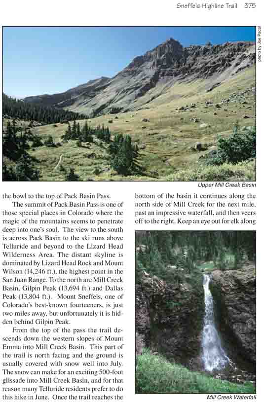
Another 500 feet of elevation gain will bring you to the
bottom of Pack Basin, an incredibly scenic alpine bowl that lies just below
the western side of Mount Emma (13,581 ft.). The trail passes the remains of
an old miner’s cabin as it approaches the basin, and a short while later the
forest suddenly ends at the edge of the tundra. The canopy of spruce and
subalpine fir gives way to an open meadow of grasses and wildflowers,
protected on two sides by a ring of 12,000- and 13,000-foot peaks. Ahead the
trail can be seen switchbacking up the north side of the bowl to the top of
Pack Basin Pass.
The summit of Pack Basin Pass is one of those special
places in Colorado where the magic of the mountains seems to penetrate deep
into one’s soul. The view to the south is across Pack Basin to the ski runs
above Telluride and beyond to the Lizard Head Wilderness Area. The distant
skyline is dominated by Lizard Head Rock and Mount Wilson (14,246 ft.), the
highest point in the San Juan Range. To the north are Mill Creek Basin,
Gilpin Peak (13,694 ft.) and Dallas Peak (13,804 ft.). Mount Sneffels, one
of Colorado’s best-known fourteeners, is just two miles away, but
unfortunately it is hidden behind Gilpin Peak.
From the top of the pass the trail descends down the
western slopes of Mount Emma into Mill Creek Basin. This part of the trail
is north facing and the ground is usually covered with snow well into July.
The snow can make for an exciting 500-foot glissade into Mill Creek Basin,
and for that reason many Telluride residents prefer to do this hike in June.
Once the trail reaches the bottom of the basin it continues along the north
side of Mill Creek for the next mile, past an impressive waterfall, and then
veers off to the right. Keep an eye out for elk along the sides of the
basin. This area is a favorite summer grazing area for the large animals and
they are seen on a fairly regular basis. Soon after the waterfall the creek
turns south and drops into Lower Mill Creek Basin while the trail continues
eastward into the Mount Sneffels Wilderness Area.
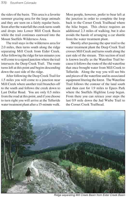
The trail stays in the wilderness area for 2.0 miles,
then turns south along the ridge separating Mill Creek from Eider Creek.
After following the ridge for ten minutes you will come to a signed junction
where the trail intersects the Deep Creek Trail. The route turns left at
this point and begins descending down the east side of the ridge.
After following the Deep Creek Trail for 1.5 miles you
will come to a junction near Mill Creek where another trail branches off to
the south and follows the creek down to Last Dollar Road. You are only 0.5
miles from the road at this point, and if you choose to turn right you will
arrive at the Telluride water treatment plant after a 15-minute walk. Most
people, however, prefer to bear left at the junction in order to complete
the loop back to the Cornet Creek Trailhead where the hike began. This
choice requires an additional 2.3 miles of walking, but it also avoids the
hassle of arranging a car shuttle from the water treatment plant.
Shortly after passing the spur trail to the water treatment plant the
Deep Creek Trail crosses Mill Creek and turns south along the east side of
the stream. This section of trail is known locally as the Waterline Trail
because it follows the route of the old waterline that once brought water
from Mill Creek to Telluride. Along the way you will see bits and pieces of
the waterline and its associated equipment littering the forest. The
Waterline Trail follows the contour of the land south and then east for 1.9
miles to Epees Park where the Sneffels Highline Loop began. From there you
can retrace your steps the last 0.9 mile down the Jud Wiebe Trail to the
Cornet Creek Trailhead.