A "giant's top hat, slightly cocked to one side" is the
way some climbers describe Uncompahgre Peak. As fourteeners go, it is a
relatively easy climb, but there is really only one way to ascend the
mountain. The peak is surrounded on three sides by vertical cliffs of
crumbly volcanic rock, but fortunately the south side consists of a sloping
ridge that is easily climbed with a minimum of scrambling.
Uncompahgre Peak was first climbed by members of the
Hayden Survey in 1874. The mountain has long been recognized for its
scenic beauty, and in the 1930s the area was included as one of the
Forest Service’s original Primitive Areas. In 1980 the peak became the
centerpiece of the Big Blue Wilderness Area, later to be enlarged and
renamed the Uncompahgre Wilderness Area.
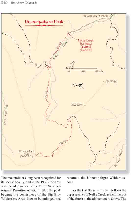
For the first 0.9 mile the trail follows the upper
reaches of Nellie Creek as it climbs out of the forest to the alpine
tundra above. The streambed is littered with volcanic boulders that have
rolled down from an ancient lava flow above the south side of the creek.
Some of the more interesting rocks are so full of holes they look like
giant blocks of Swiss Cheese. These strange boulders are the result of
sputtering around the volcanic vents, where gobs of relatively cool
putty-like lava piled up and hardened into loosely packed mounds of
basalt.
After gaining 450 feet of elevation the trail comes
to a junction where the Big Blue Trail leaves to the right. There
shouldn’t be any doubt that you must bear left at this point because
Uncompahgre Peak dominates the skyline directly in front of the trail.
It is also obvious from this perspective exactly where the trail will
go. The shear cliffs on the north side of the mountain make an easy
assent impossible from that direction, whereas the route from the south
looks quite feasible.
For the next half-hour you will be walking westward
across a gorgeous alpine tundra below the east side of the mountain. The
elevation gain along this part of the hike is minimal, but after 1.0 mile
the trail bends to the left and begins working its way up to the ridge on
the south side of the peak.
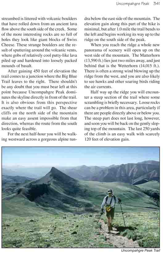
When you reach the ridge a whole new panorama of scenery
will open up on the west side of the mountain. The Matterhorn (13,590 ft.)
lies just two miles away, and just behind that is the Wetterhorn (14,015
ft.). There is often a strong wind blowing up the ridge from the west, and
you are also likely to see hawks and other soaring birds riding the air
currents.
Half way up the ridge you will encounter a steep section
of the trail where some scrambling is briefly necessary. Loose rocks can be
a problem in this area, particularly if there are people directly above or
below you. The steep part does not last long, however, and soon you will be
back on the gently sloping top of the mountain. The last 250 yards of the
climb is an easy walk with scarcely 120 feet of elevation gain.