This is one of the most popular hikes on the western side
of the Sangre de Cristo Wilderness Area. For me, the thing that makes it so
special is a magnificently situated waterfall that plunges 150 feet into the
eastern side of Willow Lake. The best time to photograph this
picture-perfect scene is in the late afternoon when the sun is low in the
west. If you are fortunate enough to be there at that magical late afternoon
moment when the lake is in shade but the fall is still in full sunlight, and
when the water is calm, you will be treated to a prize-winning view of the
fall’s reflection off the lake. It is rare, however, for the water to be
calm at that time of day.
Another reason people are drawn to Willow Lake is that it
is a popular staging area for the assent of Kit Carson Peak (14,165 ft.) and
Challenger Point (14,081 ft.). Both of these fourteeners, along with
Columbia Point (13,980 ft.) are located on the ridge directly above the
south side of the Willow Creek drainage. The 3,600-foot assent to the
summits of Kit Carson Peak and Challenger Point begins just above the east
side of Willow Lake.
From the parking area the trail goes east for 100
yards before coming to a well-marked junction between the Willow Creek
Trail and the South Crestone Trail. Turn right here onto the Willow
Creek Trail. Immediately upon leaving the junction the path dips down
into a shallow depression, crosses Crestone Creek and the Wilcox Gulch
drainage in quick succession, then climbs out to a meadow on the south
side of the drainages. Upon reaching the higher ground of the meadow the
trail proceeds eastward along the south side of Wilcox Gulch.
The route follows Wilcox Gulch for 0.3 mile, then
turns to begin a series of long, gentle switchbacks upward to the top of
the ridge that separates the Wilcox Gulch drainage from Willow Creek.
After 40 minutes of climbing through an open forest of Douglas fir and
white fir the trail reaches the top of the ridge, then it drops slightly
down the south side of the ridge toward Willow Creek.
Willow Creek, at this point, flows through a large
treeless meadow called Willow Creek Park. The 500-yard-long meadow is very
picturesque, but it seems oddly out of place in this rugged terrain. Though
it is completely surrounded by dense timber it is completely treeless and
almost perfectly flat. It appears to be the remnant of an ancient lakebed
that eventually filled with silt and was transformed into a grassy park. The
trail stays well above the north side of the meadow, but along the way you
will pass several spur trails that drop down to its northern side. During
the summer you can usually see the tents of at least one or two backpacking
parties camping on the perimeter of the park.
As you walk above Willow Creek Park notice the cleavage
in the mountains on the east side of the meadow. This is the gorge through
which Willow Creek flows and it is the route you will follow to the lake.
The trail continues to descend until it reaches the eastern end of the park,
loosing about 100 feet in all, then starts uphill again. Shortly after
leaving the meadow you will pass a Forest Service sign marking the Sangre de
Cristo Wilderness Area boundary. Beyond the sign the trail becomes
significantly rockier as it enters the Willow Creek Gorge, but the grade
continues to be relatively gentle.
As you ascend through the canyon that surrounds Willow
Creek the terrain becomes more and more rugged and the trail does a great
deal of meandering as it searches for the easiest way forward. Initially it
stays high above the north side of the creek, but about 1.0 mile after
crossing the wilderness boundary the trail comes back to Willow Creek once
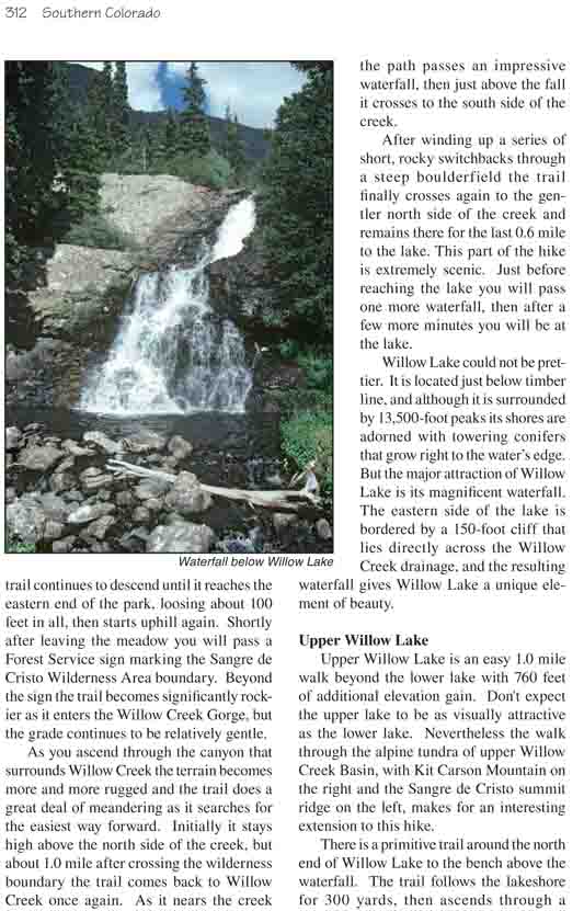
again. As it nears the creek the path passes an impressive waterfall, then
just above the fall it crosses to the south side of the creek.
After winding up a series of short, rocky switchbacks
through a steep boulderfield the trail finally crosses again to the gentler
north side of the creek and remains there for the last 0.6 mile to the lake.
This part of the hike is extremely scenic. Just before reaching the lake you
will pass one more waterfall, then after a few more minutes you will be at
the lake.
Willow Lake could not be prettier. It is located just
below timber line, and although it is surrounded by 13,500-foot peaks its
shores are adorned with towering conifers that grow right to the water’s
edge. But the major attraction of Willow Lake is its magnificent waterfall.
The eastern side of the lake is bordered by a 150-foot cliff that lies
directly across the Willow Creek drainage, and the resulting waterfall gives
Willow Lake a unique element of beauty.
Upper Willow Lake
Upper Willow Lake is an easy 1.0 mile walk beyond the
lower lake with 760 feet of additional elevation gain. Don't expect the
upper lake to be as visually attractive as the lower lake. Nevertheless the
walk through the alpine tundra of upper Willow Creek Basin, with Kit Carson
Mountain on the right and the Sangre de Cristo summit ridge on the left,
makes for an interesting extension to this hike.
There is a primitive trail around the north end of Willow
Lake to the bench above the waterfall. The trail follows the lakeshore for
300 yards, then ascends through a heavy undergrowth of willows to the more
open terrain above the fall. From there the faint trail continues east along
the south side of the creek for a short distance before it disappears. You
may see a few cairns above the fall marking another route that ascends the
northern flank of Kit Carson Mountain. As mentioned before, this is a
popular route for peak baggers wishing to climb Challenger Point and Kit
Carson Peak. The route from Willow Lake to Challenger Point is a relatively
easy 1.4 mile climb with 2,520 feet of elevation gain, and from Challenger
climbers can make a slightly more difficult traverse along the summit ridge
to Kit Carson Peak.
The easiest route to Upper Willow Lake follows along the
south side of the creek. You will see bits and pieces of a trail along the
way, but nothing that lasts very long. There are several large groves of
willows in the bottom of the basin, but you can usually find an easy way
through them. Most of the route is across a grassy tundra and the walk is
not difficult.
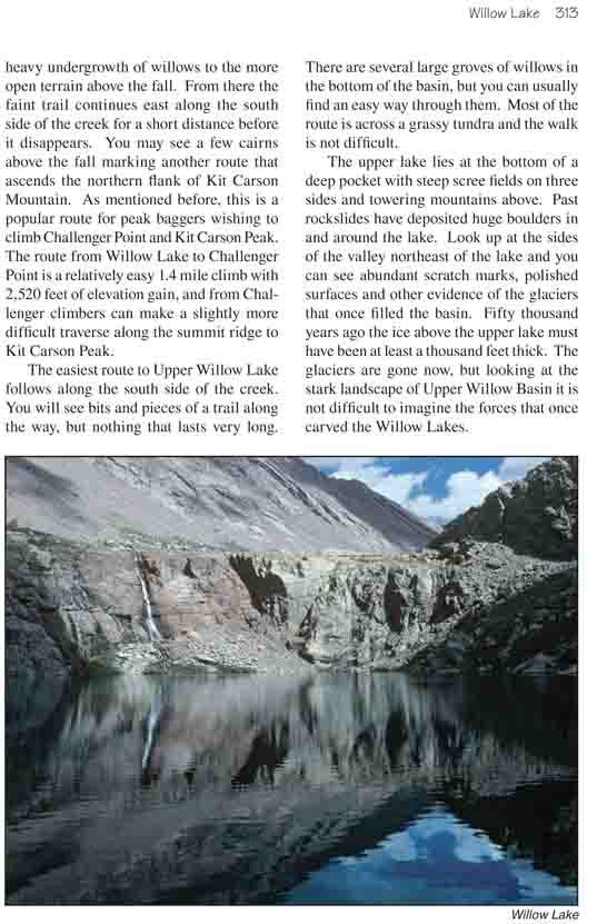
The upper lake lies at the bottom of a deep pocket with
steep scree fields on three sides and towering mountains above. Past
rockslides have deposited huge boulders in and around the lake. Look up at
the sides of the valley northeast of the lake and you can see abundant
scratch marks, polished surfaces and other evidence of the glaciers that
once filled the basin. Fifty thousand years ago the ice above the upper lake
must have been at least a thousand feet thick. The glaciers are gone now,
but looking at the stark landscape of Upper Willow Basin it is not difficult
to imagine the forces that once carved the Willow Lakes.