A hidden waterfall, several old miner’s cabins, and a
high alpine lake are the rewards of this hike. The Zapata Falls are only 0.5
mile from the trailhead, and that is as far as most people get. The cabins
are less than a mile beyond Zapata Falls, and they are also a worthwhile
goal for a short day hike into the Sangre de Cristo Mountains. The real
highlight of this hike, however, is South Zapata Lake, a small alpine lake
at the end of the trail in a majestic basin surrounded by 13,000- and
14,000-foot peaks.
It will become apparent when you begin this hike that
the trail to Zapata Falls is actually an old jeep road, and although the
road is now closed to vehicles the first 0.5 mile of the hike is not as
pretty as it might otherwise be. The jeep road ends in a shady,
tree-covered glen at the base of the mountains, where several
well-placed benches invite hikers to stop and enjoy the scenery below
the falls. The falls themselves are located inside a large notch in the
cliff face 100 feet beyond the end of the trail, and if you want to see
them you must wade through the water and enter the notch. Inside the
dark, sunless grotto you can see the 30-foot ribbon of water crashing
down from above. But if you want to photograph the falls you had better
have a waterproof camera with high-speed film and a super-wide-angle
lens.
100 feet before reaching the end of the Zapata Falls
Trail you will pass a junction with a sign pointing the way to the South
Zapata Lake Trail on your right. Turn here and follow the trail toward
the lake as it begins climbing through the juniper trees along the south
side of South Zapata Creek. There is a great view to the north along
this section of trail. The expansive sand dunes of Great Sand Dunes
National Park are clearly visible 9 miles away, and the Crestone Needle
and Crestone Peak rise dramatically above the skyline in the distance.
After 0.3 mile of climbing the trail passes the connecting path to the
South Zapata Lake Trailhead, and 10 minutes later it crosses to the
north side of South Zapata Creek.
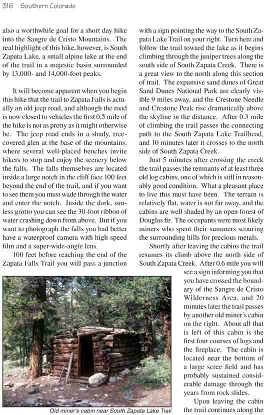
Just 5 minutes after crossing the creek the trail passes
the remnants of at least three old log cabins, one of which is still in
reasonably good condition. What a pleasant place to live this must have
been. The terrain is relatively flat, water is not far away, and the cabins
are well shaded by an open forest of Douglas fir. The occupants were most
likely miners who spent their summers scouring the surrounding hills for
precious metals.
Shortly after leaving the cabins the trail resumes its
climb above the north side of South Zapata Creek. After 0.6 mile you will
see a sign informing you that you have crossed the boundary of the Sangre de
Cristo Wilderness Area, and 20 minutes later the trail passes by another old
miner’s cabin on the right. About all that is left of this cabin is the
first four courses of logs and the fireplace. The cabin is located near the
bottom of a large scree field and has probably sustained considerable damage
through the years from rock slides.
Upon leaving the cabin the trail continues along the
bottom of the scree field for the next 1.0 mile before again crossing South
Zapata Creek. Once on the south side of the creek the trail climbs 400 feet
through the spruce and subalpine fir to the edge of timberline, and then
breaks out into a lovely alpine meadow for the last 0.6 mile to the lake. If
it is early in the summer you may have trouble following the trail through
the tall grass that fills the meadow, but the route is obvious. Finally,
after gaining 140 feet over the last 0.5 mile you will cross a low ridge and
step onto the north shore of the lake.
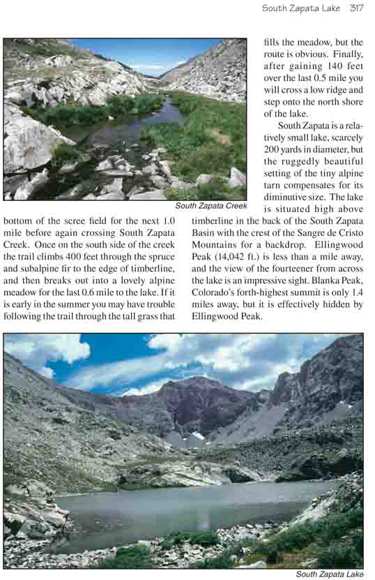
South Zapata is a relatively small lake, scarcely 200 yards in diameter,
but the ruggedly beautiful setting of the tiny alpine tarn compensates for
its diminutive size. The lake is situated high above timberline in the back
of the South Zapata Basin with the crest of the Sangre de Cristo Mountains
for a backdrop. Ellingwood Peak (14,042 ft.) is less than a mile away, and
the view of the fourteener from across the lake is an impressive sight.
Blanka Peak, Colorado’s forth-highest summit is only 1.4 miles away, but it
is effectively hidden by Ellingwood Peak.