|
Links to other sites:
Do you have any recent information to add about this road?
Ordering books & Maps
Free sample copies of Outdoor Magazines
Comments about this site or our book:

|
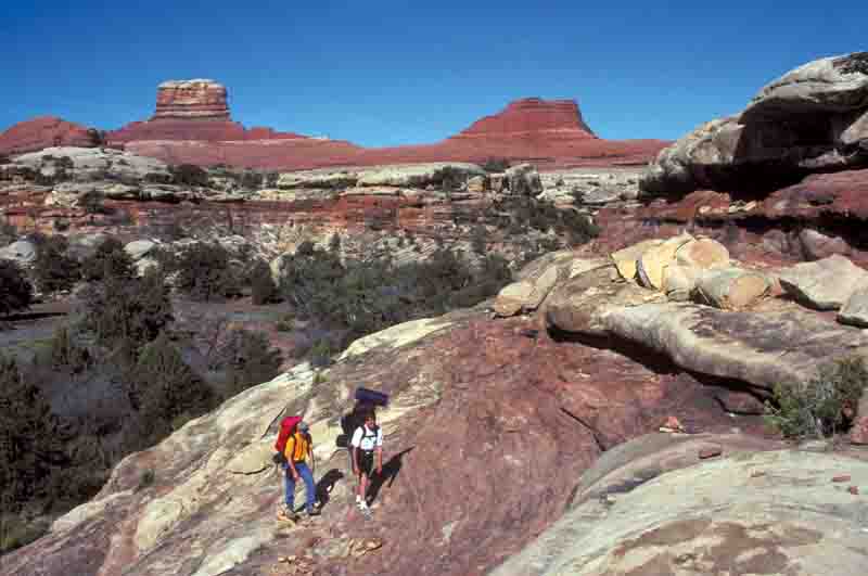
This interesting trail connects Squaw Flat Campground with the road through lower Salt Creek Canyon. An ideal way to enjoy the hike is in combination with an overnight car camp at Peekaboo Camp on the Salt Creek Road followed by a jeep ride out the next day. Most people, however, do it as a round trip from the Squaw Flat Campground in a single day.
The route crosses two other canyons on the way to Salt Creek, and some minor scrambling is required in a few places to get in and out of the streambeds. The last half of the trail is the most interesting, as the trail navigates its way across the frozen sea of slickrock separating Lost Canyon from Salt Creek Canyon. The area is a labyrinth of sandstone canyons and side canyons, which the trail avoids by following a tortuous route across the ledges and benches above the canyon rims.
Bear left at the junction 150 feet from the trailhead and begin the hike by walking in a southeasterly direction across the broad expanse of Squaw Flat. The desert terrain is uncharacteristically gentle for the first 1.5 miles, with only an occasional outcropping of sandstone along the way, but that will change soon. After 0.7 mile the trail begins skirting along the west side of a dry wash, which it crosses ten minutes later. This is Squaw Canyon, although at this point it is not really much of a canyon.
Finally, 1.7 miles from the trailhead, the trail leaves Squaw Flat and begins to enter the rugged up-and-down country that surrounds Lost Canyon. The path first climbs a low sandstone ridge, then skirts around the north side of a small canyon, and finally, with the help of a short ladder, descends to the sandy streambed below. It then proceeds down the unnamed side canyon for the next 0.8 miles to the bottom of Lost Canyon.
Lost Canyon was an important location for the early ranchers who ran cattle in the Needles District during the first part of the last century. It was important because it is one of the few canyons in this area that contains a relatively reliable water source. The cowboys maintained a permanent camp in Lost Canyon which can still be seen today. See page 162 for more information about this camp and how to get there.
You will be in Lost Canyon only briefly before climbing out its east side, and from that point to the end of the hike your feet will touch almost nothing but stone. From there the trail stays high on the canyon rims, winding around the depressions and high spots in an attempt to gain and loose as little elevation as possible. From Lost Canyon to Salt Creek Canyon is only 1.2 miles by air, but the distance by trail is twice that. None of the intervening canyons are more than 200 feet deep, but climbing in and out of them would be very impractical. The route taken by the trail, while not the shortest way, is the path of least energy.
A few hundred yards before it reaches Salt Creek Canyon the trail enters a crack in the sandstone where the Park Service has placed another short ladder to facilitate the descent. From there the trail, once again on dirt, continues down a short distance to the flat sandy floor of the canyon. Peekaboo Camp is just 100 feet south of the end of the trail.
Just before reaching Salt Creek Road the trail passes below an interesting panel of Indian pictographs. If you look up to your right you can easily see them from the trail. This art was painted on the cliff face by members of the Fremont culture sometime before 1300 AD. The white, shield-like drawings are typical of Fremont art, although there is no evidence that the Fremonts ever established permanent dwellings in the canyon. Look carefully and you will see that the drawings were laid down over the top of another very faint collection of reddish-brown paintings that are obviously much older. In fact the underlying art was painted on the cliff face at least a thousand years before the Fremont artist deposited his work. It was placed there by the Archaic People who lived in these canyons between 2,000 and 8,000 years ago. Please be careful not to touch or otherwise damage the ancient paintings.
|