Bloods Lake Lackawaxen Lake Trail
excerpted from our book
Salt Lake City's Incredible Hiking and Biking Trails
pages 308-311
|
Buy book directly from the author!
Salt Lake City's Incredible Hiking and Biking Trails
- has access info for 73 trailheads
- 73 colorful trail maps
- 325 full color photographs
- loads of hiking tips
|
regularly $19.95
now on sale for only
$9.95
click here
for book orders
|
 Lackawaxen Lake is a beautiful alpine pond that lies just south of Guardsman Pass near the boundary between Salt Lake County and Wasatch
County. The small, oddly named lake (apparently named after a river in northeast Pennsylvania) is partially hidden in a depression some 700 feet below the Clayton
Peak summit ridge. The trail is only 1.6 miles long, yet, surprisingly, Lackawaxen Lake is not often visited. After the first half-mile the route passes Bloods
Lake, a much more popular destination, where the path seems to end, and most people do not realize that there is another even more beautiful lake just a mile away.
With a little effort, however, you can find the more primitive trail that continues on past Bloods Lake to Lackawaxen
Lake.
Lackawaxen Lake is a beautiful alpine pond that lies just south of Guardsman Pass near the boundary between Salt Lake County and Wasatch
County. The small, oddly named lake (apparently named after a river in northeast Pennsylvania) is partially hidden in a depression some 700 feet below the Clayton
Peak summit ridge. The trail is only 1.6 miles long, yet, surprisingly, Lackawaxen Lake is not often visited. After the first half-mile the route passes Bloods
Lake, a much more popular destination, where the path seems to end, and most people do not realize that there is another even more beautiful lake just a mile away.
With a little effort, however, you can find the more primitive trail that continues on past Bloods Lake to Lackawaxen
Lake.
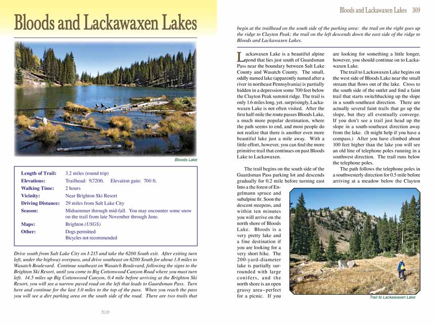
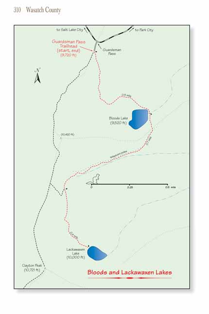
The trail begins on the south side of the Guardsman Pass parking lot and descends gradually for 0.2 mile before turning east Into a the forest of Engelmann spruce
and subalpine fir. Soon the descent steepens, and within ten minutes you will arrive on the north shore of Bloods Lake. Bloods is a very pretty lake and a fine
destination if you are looking for a very short hike. The 200-yard-diameter lake is partially surrounded with large conifers, and the north shore is an open grassy
area-perfect for a picnic. If you are looking for something a little longer, however, you should continue on to Lackawaxen Lake.
The trail to Lackawaxen Lake begins on the west side of Bloods Lake near the small stream that flows out of the lake. Cross to the south side of the outlet and find
a faint trail that starts switchbacking up the slope in a south-southeast direction. There are actually several faint trails that go up the slope, but they all
eventually converge. If you donĺt see a trail just head up the slope in a south-southeast direction away from the lake. (It might help if you have a compass.)
After you have climbed about 100 feet higher than the lake you will see an old line of telephone poles running in a southwest direction. The trail runs below
the telephone poles.
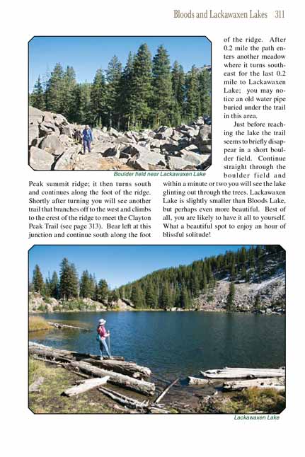
The path follows the telephone poles in a southwesterly direction for 0.5 mile before arriving at a meadow below the Clayton Peak summit ridge; it then turns south
and continues along the foot of the ridge. Shortly after turning you will see another trail that branches off to the west and climbs to the crest of the ridge to
meet the Clayton Peak Trail (see page 313). Bear left at this junction and continue south along the foot of the ridge. After 0.2 mile the path enters another
meadow where it turns southeast for the last 0.2 mile to Lackawaxen Lake; you may notice an old water pipe buried under the trail in this area.
Just before reaching the lake the trail seems to briefly disappear in a short boulder field. Continue straight through the boulder field and within a minute or
two you will see the lake glinting out through the trees. Lackawaxen Lake is slightly smaller than Bloods Lake, but perhaps even more beautiful. Best of all, you
are likely to have it all to yourself. What a beautiful spot to enjoy an hour of blissful solitude!
Note to web developers: You may copy this material onto your site, but in return please include a link to my home page
www.utahtrails.com. Thank you, David Day (utahdavidday at gmail.com)
Click here to see more
trails near Salt Lake City
ę Rincon Publishing Company, all rights reserved
|