Davis Creek Waterfalls
excerpted from our book
Salt Lake City's Incredible Hiking and Biking Trails
pages 256-260
|
Buy book directly from the author!
Salt Lake City's Incredible Hiking and Biking Trails
- has access info for 73 trailheads
- 73 colorful trail maps
- 325 full color photographs
- loads of hiking tips
|
regularly $19.95
now on sale for only
$9.95
click here
for book orders
|
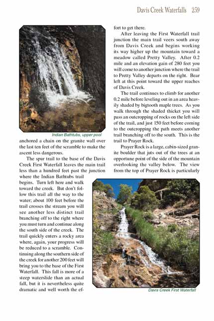 At first glance this appears to be an easy hike: only 2.5 miles round trip with 1,280 feet of elevation gain, and although the
Davis Creek Waterfalls trail is uncomfortably steep in a few places it is mostly well maintained and easy to follow. The downside is that getting to the waterfalls requires a
great deal of off-trail scrambling and can be dangerous if you are not careful. I wouldn’t recommend the hike for families with children, but the wild
beauty of Davis Creek cannot be ignored, and if you are up for a bit of adventure this might be just what you are looking for.
At first glance this appears to be an easy hike: only 2.5 miles round trip with 1,280 feet of elevation gain, and although the
Davis Creek Waterfalls trail is uncomfortably steep in a few places it is mostly well maintained and easy to follow. The downside is that getting to the waterfalls requires a
great deal of off-trail scrambling and can be dangerous if you are not careful. I wouldn’t recommend the hike for families with children, but the wild
beauty of Davis Creek cannot be ignored, and if you are up for a bit of adventure this might be just what you are looking for.
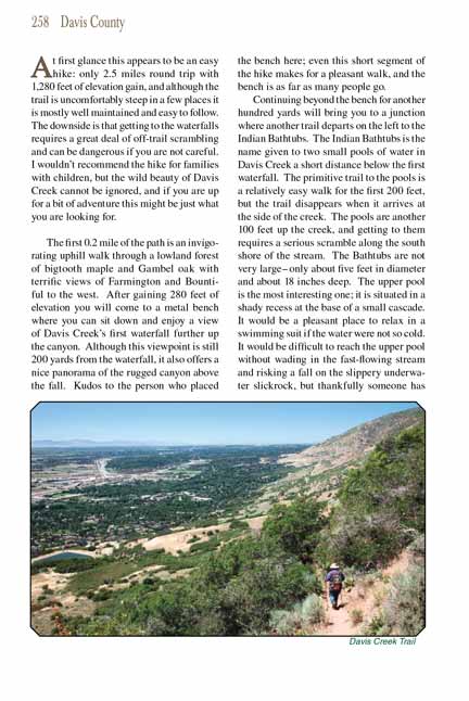
The first 0.2 mile of the Davis Creek
Waterfalls trail is an invigorating uphill walk through a lowland forest of bigtooth maple and Gambel oak with terrific views of Farmington
and Bountiful to the west. After gaining 280 feet of elevation you will come to a metal bench where you can sit down and enjoy a view of Davis Creek’s
first waterfall further up the canyon. Although this viewpoint is still 200 yards from the waterfall, it also offers a nice panorama of the rugged canyon
above the fall. Kudos to the person who placed the bench here; even this short segment of the hike makes for a pleasant walk, and the bench is as far
as many people go.
Continuing beyond the bench for another hundred yards will bring you to a junction where another trail departs on the left to the Indian Bathtubs. The
Indian Bathtubs is the name given to two small pools of water in Davis Creek a short distance below the first waterfall. The primitive trail to the pools
is a relatively easy walk for the first 200 feet, but the trail disappears when it arrives at the side of the creek. The pools are another 100 feet up
the creek, and getting to them requires a serious scramble along the south shore of the stream. The
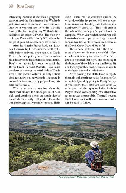
Indian Bathtubs are not very large-only about five feet
in diameter and about 18 inches deep. The upper Indian Bathtubs pool is the most interesting one; it is situated in a shady recess at the base of a small cascade.
It would be a pleasant place to relax in a swimming suit if the water were not so cold. It would be difficult to reach the upper
Indian Bathtubs pool without wading
in the fast-flowing stream and risking a fall on the slippery underwater slickrock, but thankfully someone has anchored a chain on the granite wall
over the last ten feet of the scramble to make the ascent less dangerous.
The spur trail to the base of the Davis Creek First Waterfall leaves the main trail less than a hundred feet past the junction where the Indian Bathtubs
trail begins. Turn left here and walk toward the creek. But don’t follow this trail all the way to the water; about 100 feet before the trail crosses
the stream you will see another less distinct trail branching off to the right where you must turn and continue along the south side of the creek. The
trail quickly enters a rocky area where, again, your progress will be reduced to a scramble. Continuing along the southern side of the creek for another
200 feet will bring you to the base of the Davis Creek First Waterfall. This fall is more of a steep waterslide than an actual fall, but it is nevertheless quite
dramatic and well worth the effort to get there.
 After leaving the First Waterfall trail junction the main trail veers south away from Davis Creek and begins working its way
higher up the mountain toward a meadow called Pretty Valley. After 0.2 mile and an elevation gain of 280 feet you will come to another junction where the
trail to Pretty Valley departs on the right. Bear left at this point toward the upper reaches of Davis Creek.
After leaving the First Waterfall trail junction the main trail veers south away from Davis Creek and begins working its way
higher up the mountain toward a meadow called Pretty Valley. After 0.2 mile and an elevation gain of 280 feet you will come to another junction where the
trail to Pretty Valley departs on the right. Bear left at this point toward the upper reaches of Davis Creek.
The trail continues to climb for another 0.2 mile before leveling out in an area heavily shaded by bigtooth maple trees. As you walk through the shaded
thicket you will pass an outcropping of rocks on the left side of the trail, and just 150 feet before coming to the outcropping the path meets another
trail branching off to the south. This is the trail to Prayer Rock.
Prayer Rock is a large, cabin-sized granite boulder that juts out of the trees at an opportune point of the side of the mountain overlooking the valley below.
The view from the top of Prayer Rock is particularly interesting because it includes a gorgeous panorama of the Farmington Bay Wetlands just three miles to
the west. From this vantage point you can see the entire six-mile loop of the Farmington Bay Wetlands trail described on pages 249-252. The side trip to
Prayer Rock will add only 0.2 mile to the length of your hike, so be sure not to miss it.
After leaving the Prayer Rock trail junction the main trail continues for another 0.2 mile before arriving, once again, at Davis Creek. At that point you
will see another path that crosses the stream and heads north. Don’t take that trail; in order to reach the Davis Creek Second Waterfall you must continue
east along the south side of Davis Creek. The second waterfall is only a short distance away, but be warned: the route is not well defined and many people
doing this hike fail to find it.
When you pass the junction where the other trail crosses the creek you must bear right and continue along the south side of the creek for exactly 100 yards.
There the trail passes a primitive campsite called Hells Hole. Turn into the campsite and on the other side of the fire pit you will see another hiker-made
trail heading into the trees in a northeasterly direction. This trail ends at the side of the creek just 50 yards from the campsite. When you reach the
creek you will have to bushwack upstream along the creek for another 100 yards to reach the bottom of the Davis Creek Second Waterfall.
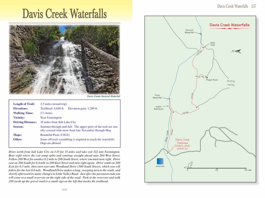
The second waterfall, like the first, is more of a waterslide than a waterfall. Nevertheless, it is very impressive. The fall is about a hundred feet high,
and standing in the bottom of the wild canyon amidst the din and the spay of the chaotic cascade is sure to make hearts pound a little faster.
After passing the Hells Hole campsite the main trail continues south for another 0.4 mile, finally ending pretty in Pretty Valley. If you follow that
route you will, after 0.2 mile, pass another spur trail that leads to Prayer Rock; consequently two alternative return routes are possible. The trail
beyond Hells Hole is not well used, however, and it can be hard to follow.
Note to web developers: You may copy this material onto your site, but in return please include a link to my home page
www.utahtrails.com. Thank you, David Day (utahdavidday at gmail.com)
Click here to see more
trails near Salt Lake City
© Rincon Publishing Company, all rights reserved
|