Dry Canyon Loop Trail
excerpted from our book
Salt Lake City's Incredible Hiking and Biking Trails
pages 203-207
|
Buy book directly from the author!
Salt Lake City's Incredible Hiking and Biking Trails
- has access info for 73 trailheads
- 73 colorful trail maps
- 325 full color photographs
- loads of hiking tips
|
regularly $19.95
now on sale for only
$9.95
click here
for book orders
|
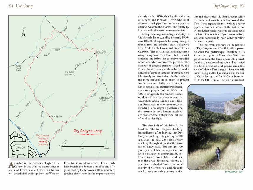
 As noted in the previous chapter, Dry Canyon is one of three major canyons north of Provo where hikers can follow well
established trails up from the Wasatch Front to the meadows above. These trails have been in use for over a hundred and fifty years, first by the
Mormon settlers who were grazing their sheep in the upper meadows as early as the 1850s, then by the residents of Linden and Pleasant Grove who built
reservoirs and pipe lines in the canyons to channel water to their farms, and finally by hunters and other outdoor recreationists.
As noted in the previous chapter, Dry Canyon is one of three major canyons north of Provo where hikers can follow well
established trails up from the Wasatch Front to the meadows above. These trails have been in use for over a hundred and fifty years, first by the
Mormon settlers who were grazing their sheep in the upper meadows as early as the 1850s, then by the residents of Linden and Pleasant Grove who built
reservoirs and pipe lines in the canyons to channel water to their farms, and finally by hunters and other outdoor recreationists.
Sheep ranching was a huge industry in Utah’s early history, and by the early 1900s over 100,000 sheep could be seen grazing in the summertime in the lush
grasslands above Dry Creek, Battle Creek, and Grove Creek Canyons. The environmental damage from overgrazing was tremendous, but it wasn’t until the late
1950s that extensive remedial action was taken to correct the problem. The number of grazing permits issued by the Forest Service was greatly reduced,
and a network of contour trenches or terraces were laboriously constructed on the slopes above the three canyons in an effort to prevent further erosion.
Fifty years later, it has to be said that the massive federal assistance program of the 1950s and '60s to revegetate the western slopes of Mount
Timpanogos and restore the watersheds above Lindon and Pleasant Grove was an enormous success. Flooding is no longer a problem, and the mountain's
once barren meadows are now covered with grasses that are often shoulder high.
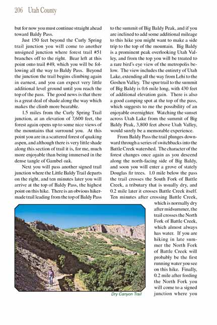
The first half of this hike is the hardest. The
Dry Canyon Trail begins climbing immediately after leaving the Dry Canyon parking lot, gaining 2,900 feet over the next
2.6 miles before reaching the highest point at the summit of Baldy Pass. For the first 100 yards you will be climbing a series of knee-busting steps
constructed by the Forest Service from old railroad ties; then the grade diminishes slightly as you enter a shaded forest composed mainly of Gambel oak
and bigtooth maple. As you walk you may notice bits and pieces of an old abandoned pipeline that was built sometime before World War Two. It was
replaced in the 1940s by a newer pipeline, buried underneath the first part of the
Dry Canyon Trail, that carries water to an aqueduct at the base of mountains.
If you listen carefully you can occasionally hear water gurgling beneath the path.
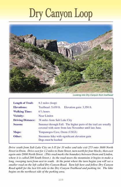
The trail works its way up the left side of Dry Canyon, and after 0.5 mile it passes between two picturesque limestone cliffs known locally as the Great
Blue Gate. Beyond the Gate the forest opens into a small but scenic meadow where you will be treated to a brief stretch of level ground and a fine view
of Mount Timpanogos. Soon you will come to a signed trail junction where the trail to Curly Spring and Battle Creek branches off to the left. This will
be your return trail, but for now you must continue straight ahead on the Dry
Canyon Trail toward Baldy Pass.
Just 150 feet beyond the Curly Spring trail junction you will come to another unsigned junction where forest trail #51 branches off to the right. Bear
left at this point onto trail #49, which you will be following all the way to Baldy Pass. Beyond the junction the
Dry Canyon Trail begins climbing again in earnest,
and you can expect very little additional level ground until you reach the top of the pass. The good news is that there is a great deal of shade along
the way which makes the climb more bearable.
1.5 miles from the Curly Spring Trail junction, at an elevation of 7,600 feet, the forest again opens up to some nice views of the mountains that surround
you. At this point you are in a scattered forest of quaking aspen, and although there is very little shade along this section of
the Dry Canyon Trail it is, for me,
much more enjoyable than being immersed in the dense tangle of Gambel oak.
 Next you will pass another signed trail junction where the Little Baldy Trail departs on the right, and ten minutes later you
will arrive at the top of Baldy Pass, the highest point on this hike. There is an obvious hiker-made trail leading from the top of Baldy Pass to the summit
of Big Baldy Peak, and if you are inclined to add some additional mileage to this hike you might want to make a side trip to the top of the mountain.
Big Baldy is a prominent peak overlooking Utah Valley, and from the top you will be treated to a rare bird’s eye view of the metropolis below. The
view includes the entirety of Utah Lake, extending all the way from Lehi to the Goshen Valley. The spur trail to the summit of Big Baldy is 0.6 mile
long, with 430 feet of additional elevation gain. There is also a good camping spot at the top of the pass, which suggests to me the possibility of
an enjoyable overnighter. Watching the sunset across Utah Lake from the summit of Big Baldy Peak, 3,800 feet above Utah Valley, would surely be a
memorable experience.
Next you will pass another signed trail junction where the Little Baldy Trail departs on the right, and ten minutes later you
will arrive at the top of Baldy Pass, the highest point on this hike. There is an obvious hiker-made trail leading from the top of Baldy Pass to the summit
of Big Baldy Peak, and if you are inclined to add some additional mileage to this hike you might want to make a side trip to the top of the mountain.
Big Baldy is a prominent peak overlooking Utah Valley, and from the top you will be treated to a rare bird’s eye view of the metropolis below. The
view includes the entirety of Utah Lake, extending all the way from Lehi to the Goshen Valley. The spur trail to the summit of Big Baldy is 0.6 mile
long, with 430 feet of additional elevation gain. There is also a good camping spot at the top of the pass, which suggests to me the possibility of
an enjoyable overnighter. Watching the sunset across Utah Lake from the summit of Big Baldy Peak, 3,800 feet above Utah Valley, would surely be a
memorable experience.
From Baldy Pass the trail plunges downward through a series of switchbacks into the Battle Creek watershed. The character of the forest changes once again
as you descend along the north-facing side of Big Baldy, and soon you will enter a grove of stately Douglas fir trees. 1.0 mile below the pass the trail
crosses the South Fork of Battle Creek, a tributary that is usually dry, and 0.2 mile later it crosses Battle Creek itself. Ten minutes after crossing Battle
Creek, which is normally dry after midsummer, the trail crosses the North Fork of Battle Creek, which almost always has water. If you are hiking in late
summer the North Fork of Battle Creek will probably be the first running water you see on this hike. Finally, 0.2 mile after fording the North Fork you
will come to a signed junction where you must turn left onto the Battle Creek Trail.
It is a pleasant 1.0-mile downhill walk on the Battle Creek Trail to the Curly Spring Trail junction. When you reach the junction you are actually only 1.2
miles from the Battle Creek Trailhead, so it is possible to shorten this hike by 1.7 miles if you decide to end there instead of completing the loop and
ending at the Dry Canyon Trailhead. (See page 199 for more information about the Battle Creek Trail.) A small sign on the north side of Battle Creek marks
the point where you must leave the Battle Creek Trail for Curly Spring and Dry Canyon. There is no bridge and Curly Spring is on the opposite side of the
creek, so prepare to get your feet wet. The creek is normally about 15 feet wide and 10 inches deep.
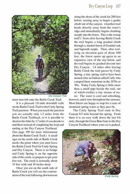
Once you are on the south side of Battle Creek you will see the continuation of the trail following downstream along the shore of the creek for 200 feet before
veering away to begin a gentle climb out of the canyon. (Another trail heads directly away from the water’s edge and immediately begins climbing steeply
into the forest. This is the wrong trail!) Soon after leaving Battle Creek the trail begins a long gradual climb through a shaded forest of Gambel oak
and bigtooth maple. Then, after realizing an elevation gain of about 400 feet, the forest opens up again to an expansive view of the city below, and the
trail begins its gradual descent into Dry Canyon. 1.8 miles after leaving Battle Creek the trail passes by Curly Spring, a tiny spring said to have been
named after an Indian called Curly who camped there sometime in the 1870s or '80s. Today Curly Spring is little more than a small pipe beside the trail,
out of which trickles a tiny stream of water. The water is cool and refreshing, however, and it runs throughout the summer. Most hikers are happy
to stop for a taste of mountain spring water as they pass by.
The Curly Spring Trail ends in Dry Canyon 0.5 mile beyond the spring. From there it is an easy walk down the last 0.6 mile, through the Great Blue Gate to
the Dry Canyon Trailhead where your car is parked.
Note to web developers: You may copy this material onto your site, but in return please include a link to my home page
www.utahtrails.com. Thank you, David Day (utahdavidday at gmail.com)
Click here to see more
trails near Salt Lake City
© Rincon Publishing Company, all rights reserved
|