Great Western Trail
via Red Pine Road Trail
excerpted from our book
Salt Lake City's Incredible Hiking and Biking Trails
pages 54-57
|
Buy book directly from the author!
Salt Lake City's Incredible Hiking and Biking Trails
- has access info for 73 trailheads
- 73 colorful trail maps
- 325 full color photographs
- loads of hiking tips
|
regularly $19.95
now on sale for only
$9.95
click here
for book orders
|
 The Great Western Trail is a planned 4,455-mile-long system of trails that will someday allow hikers to walk all the way from the
Canadian border, through Montana, Wyoming, Idaho, Utah and Arizona, to the Mexican border. The route, however, is still far from complete; at the moment it is
mostly a collection of existing trails that are often poorly connected. In some areas the connecting paths are nonexistent, and in others they are not foot
trails at all, but roads. The Utah portion of the Great Western Trail consists of about 1,600 miles of existing roads and trails that will eventually be
connected by some 100 miles of new trails. It begins near Bear Lake in the Wasatch-Cache National Forest and proceeds south, through mostly National Forest
and BLM land, to a point on the Arizona Border about 45 miles east of Kanab.
The Great Western Trail is a planned 4,455-mile-long system of trails that will someday allow hikers to walk all the way from the
Canadian border, through Montana, Wyoming, Idaho, Utah and Arizona, to the Mexican border. The route, however, is still far from complete; at the moment it is
mostly a collection of existing trails that are often poorly connected. In some areas the connecting paths are nonexistent, and in others they are not foot
trails at all, but roads. The Utah portion of the Great Western Trail consists of about 1,600 miles of existing roads and trails that will eventually be
connected by some 100 miles of new trails. It begins near Bear Lake in the Wasatch-Cache National Forest and proceeds south, through mostly National Forest
and BLM land, to a point on the Arizona Border about 45 miles east of Kanab.
In spite of the fact that the Great Western Trail remains unfinished, there are many beautiful hiking paths along its length. One such segment is the 12-mile
trail that runs from Mill Creek Canyon along the Wasatch Crest to Guardsman Pass. The loop hike described here uses the Red Pine Road Trail to get from the
Mill Creek Canyon Road to the top of the Wasatch Crest and then follows the Great Western Trail for 3.2 miles back to the starting point. It is a delightful
walk, but be warned: it is also one of the most popular mountain biking trails in the Salt Lake area. Bicycles are allowed in Mill Creek Canyon only on
even-numbered days, so if you are looking for more solitude you might want to do this hike on an odd-numbered day.
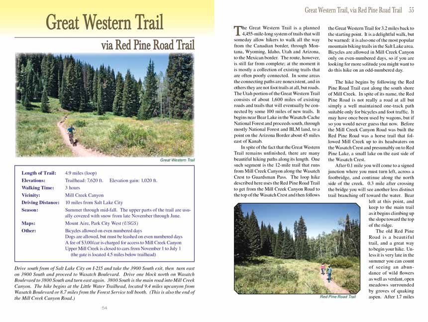
The hike begins by following the Red Pine Road Trail east along the south shore of Mill Creek. In spite of its name, the Red Pine Road is not really a road at
all but simply a well maintained one-track path suitable only for bicycles and foot traffic. It may have once been used by wagons, but if so you would never
guess that now. Before the Mill Creek Canyon Road was built the Red Pine Road was a horse trail that followed Mill Creek up to its headwaters on the Wasatch
Crest and presumably on to Red Pine Lake, a small lake on the east side of the Wasatch Crest.
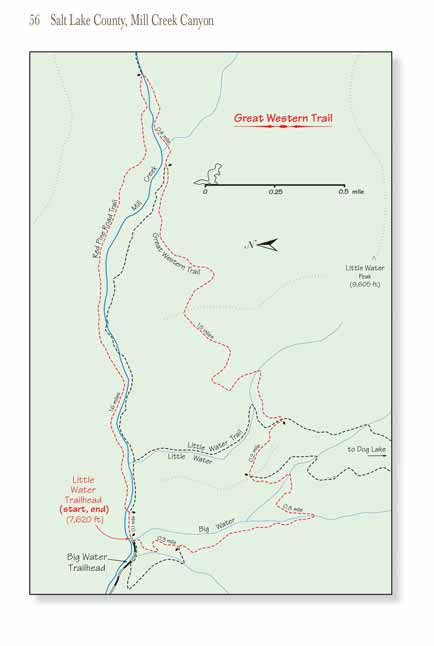
After 0.1 mile you will come to a signed junction where you must turn left, across a footbridge, and continue along the north side of the creek. 0.3 mile after
crossing the bridge you will see another less distinct trail branching off toward the water. Bear left at this point, and keep to the main trail as it begins
climbing up the slope toward the top of the ridge.
The old Red Pine Road is a beautiful trail, and a great way to begin your hike. Unless it is very late in the summer you can count of seeing an abundance of wild
flowers as well as verdant, open meadows surrounded by groves of quaking aspen. After 1.7 miles and an elevation gain of 980 feet you will meet the Great Western
Trail, where you must turn right to complete the loop.
If you are hiking on an even numbered day you will see a lot of mountain bikers along the rest of this hike. Most of them will be traveling in the same direction
as you, having started their ride at Guardsman Pass above Cottonwood Canyon. Others begin their ride in Mill Creek Canyon and do the same loop described here,
although often in the opposite direction.
For the next 1.8 miles the Great Western Trail makes a very gradual descent of about 220 feet as it drops below the west side of the Wasatch Crest. Again, you
will pass through several high alpine meadows with lots of wildflowers. After 0.4 mile you will pass an unmarked trail on the right that descends back into Mill
Creek Canyon. This 1.3-mile-long trail descends along the south side of Mill Creek and ultimately joins the Red Pine Road Trail at the footbridge near the
trailhead. The trail is unmaintained and somewhat more primitive than the Red Pine Road Trail, but if you are looking for a shorter loop this trail offers an
optional return path to the trailhead.
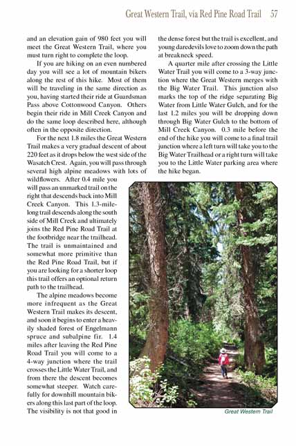
The alpine meadows become more infrequent as the Great Western Trail makes its descent, and soon it begins to enter a heavily shaded forest of Engelmann spruce
and subalpine fir. 1.4 miles after leaving the Red Pine Road Trail you will come to a 4-way junction where the
Great Western Trail crosses the Little Water Trail, and from
there the descent becomes somewhat steeper. Watch carefully for downhill mountain bikers along this last part of the loop. The visibility is not that good
in the dense forest but the trail is excellent, and young daredevils love to zoom down the path at breakneck speed.
A quarter mile after crossing the Little Water Trail you will come to a 3-way junction where the Great Western
Trail merges with the Big Water Trail. This junction
also marks the top of the ridge separating Big Water from Little Water Gulch, and for the last 1.2 miles you will be dropping down through Big Water Gulch to
the bottom of Mill Creek Canyon. 0.3 mile before the end of the hike you will come to a final trail junction where a left turn will take you to the Big Water
Trailhead or a right turn will take you to the Little Water parking area where the hike began.
Note to web developers: You may copy this material onto your site, but in return please include a link to my home page
www.utahtrails.com. Thank you, David Day (utahdavidday
at gmail.com)
Click here to see more
trails near Salt Lake City
© Rincon Publishing Company, all rights reserved
|