Grove Creek Battle Creek Trail
excerpted from our book
Salt Lake City's Incredible Hiking and Biking Trails
pages 199-202
|
Buy book directly from the author!
Salt Lake City's Incredible Hiking and Biking Trails
- has access info for 73 trailheads
- 73 colorful trail maps
- 325 full color photographs
- loads of hiking tips
|
regularly $19.95
now on sale for only
$9.95
click here
for book orders
|

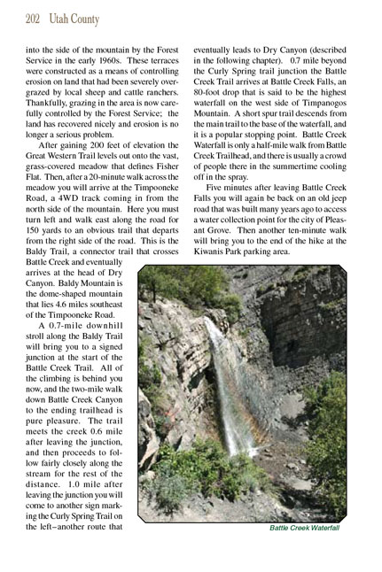 The western slopes of Mount Timpanogos contain some great hiking opportunities for people living in Provo and the adjacent
towns. The lower part of the mountain is serrated by a series of deep canyons that drain the snow fields above, and nearly all of the canyons contain
developed trails. Three particularly interesting trails climb upward from the towns of Lindon and Pleasant Grove, through Dry Canyon, Battle Creek
Canyon, and Grove Creek Canyon, to a high plateau on the west side of the Timpanogos summit ridge. The three trails are all connected at the top by a segment
of the Great Western Trail; hence several loop hikes are possible.
The western slopes of Mount Timpanogos contain some great hiking opportunities for people living in Provo and the adjacent
towns. The lower part of the mountain is serrated by a series of deep canyons that drain the snow fields above, and nearly all of the canyons contain
developed trails. Three particularly interesting trails climb upward from the towns of Lindon and Pleasant Grove, through Dry Canyon, Battle Creek
Canyon, and Grove Creek Canyon, to a high plateau on the west side of the Timpanogos summit ridge. The three trails are all connected at the top by a segment
of the Great Western Trail; hence several loop hikes are possible.
The hike I will describe here goes up Grove Creek to its headwaters, then crosses Fisher Flat on the Great Western Trail, and finally descends through
Battle Creek Canyon to the town of Pleasant Grove. Along the way you will pass two major waterfalls and several smaller ones, and the views of Mount
Timpanogos rising above the gorgeous Fisher Flat Meadow will take your breath away. The very best time to do this hike is around the first of June,
after the snow in the canyons has melted but while there is still ample snow on the summit ridge. Then, for a few weeks, the meadows are a vivid
green, the wild flowers are in bloom, and the waterfalls are running at their full capacity. Don’t expect too much solitude, though. These trails
are very popular with the locals.
For the first 0.2 mile you will be following an old, unused jeep road that proceeds along the north side of Grove Creek. Soon, however, the road dips
to the right and ends at the water’s edge. Bear left at this point and follow the footpath as it veers away from the road and continues climbing along
the left side of the stream. Then, 0.5 mile from the trailhead, you will come to a switchback where the
Grove Creek trail makes a sharp turn away from the creek
to begin climbing up the north side of the canyon.
After some 400 feet of elevation gain the trail doubles back and resumes a gradual uphill climb in a northeasterly direction. This is a particularly
interesting part of the trail. There are gorgeous views both of Mount Timpanogos and Utah Valley with little vegetation to impede the scenery. The
trail crosses the talus slopes below Mahogany Mountain, further to the north, and in several places dynamite has been used to carve a path out of the
cliffs. 1.2 miles after leaving the creek you will see a picturesque waterfall 160 feet below the trail in the bottom of the canyon. Then, 0.1 mile
later, the Grove Creek trail arrives once again at the canyon floor where it crosses to the south side of the creek and begins climbing again through a grove of
huge Douglas fir trees.
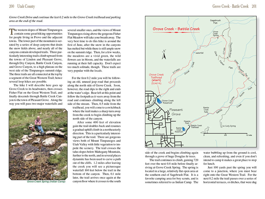
The trail continues to climb, gaining 720 feet over the next 0.8 mile before finally arriving at Grove Creek Spring. The spring is located in a large,
relatively flat open area at the southern end of Sagebrush Flat. It is a favorite camping area for boy scouts, and is sometimes referred to as Indian
Camp. The water bubbling up from the ground is cool, clean, and refreshing, and even if you don’t intend to camp it makes a great place to stop for
lunch.
Just 100 yards past the spring you will come to a junction, where you must bear right onto the Great Western Trail. For the next 0.2 mile the trail
passes over a series of horizontal terraces, or ditches, that were dug into the side of the mountain by the Forest Service in the early 1960s. These
terraces were constructed as a means of controlling erosion on land that had been severely overgrazed by local sheep and cattle ranchers. Thankfully,
grazing in the area is now carefully controlled by the Forest Service; the land has recovered nicely and erosion is no longer a serious problem.
After gaining 200 feet of elevation the Great Western Trail levels out onto the vast, grass-covered meadow that defines Fisher Flat. Then, after a
20-minute walk across the meadow you will arrive at the Timpooneke Road, a 4WD track coming in from the north side of the mountain. Here you must turn
left and walk east along the road for 150 yards to an obvious trail that departs from the right side of the road. This is the Baldy Trail, a connector
trail that crosses Battle Creek and eventually arrives at the head of Dry Canyon. Baldy Mountain is the dome-shaped mountain that lies 4.6 miles
southeast of the Timpooneke Road.
A 0.7-mile downhill stroll along the Baldy Trail will bring you to a signed junction at the start of the Battle Creek Trail. All of the climbing is
behind you now, and the two-mile walk down Battle Creek Canyon to the ending trailhead is pure pleasure. The trail meets the creek 0.6 mile after
leaving the junction, and then proceeds to follow fairly closely along the stream for the rest of the distance. 1.0 mile after leaving the junction
you will come to another sign marking the Curly Spring Trail on the left-another route that eventually leads to Dry Canyon (described in the following
chapter). 0.7 mile beyond the Curly Spring trail junction the Battle Creek Trail arrives at Battle Creek Falls, an 80-foot drop that is said to be
the highest waterfall on the west side of Timpanogos Mountain. A short spur trail descends from the main trail to the base of the waterfall, and
it is a popular stopping point. Battle Creek Waterfall is only a half-mile walk from Battle Creek Trailhead, and there is usually a crowd of people
there in the summertime cooling off in the spray.
Five minutes after leaving Battle Creek Falls you will again be back on an old jeep road that was built many years ago to access a water collection point
for the city of Pleasant Grove. Then another ten-minute walk will bring you to the end of the hike at the Kiwanis Park parking area.
Note to web developers: You may copy this material onto your site, but in return please include a link to my home page
www.utahtrails.com. Thank you, David Day (utahdavidday at gmail.com)
Click here to see more
trails near Salt Lake City
© Rincon Publishing Company, all rights reserved
|