Jordan River Parkway Trail
Bluffdale to Saratoga Springs
excerpted from our book
Salt Lake City's Incredible Hiking and Biking Trails
pages 221-229
|
Buy book directly from the author!
Salt Lake City's Incredible Hiking and Biking Trails
- has access info for 73 trailheads
- 73 colorful trail maps
- 325 full color photographs
- loads of hiking tips
|
regularly $19.95
now on sale for only
$9.95
click here
for book orders
|
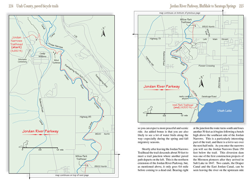 As mentioned in previous chapters, the Jordan River Parkway
Trail is a paved multiuse recreational trail that begins in Davis County near
the northern end of the Jordan River and follows it south for a distance of 45 miles to its inlet on the shore of Utah Lake. This chapter describes the last 9.8
miles of the Jordan River Parkway Trail from the Jordan Narrows Trailhead in Bluffdale to the Inlet Park Trailhead in Saratoga Springs. The trail also passes through Willow Park
in Lehi, an alternative place to stop if you are looking for a shorter ride.
As mentioned in previous chapters, the Jordan River Parkway
Trail is a paved multiuse recreational trail that begins in Davis County near
the northern end of the Jordan River and follows it south for a distance of 45 miles to its inlet on the shore of Utah Lake. This chapter describes the last 9.8
miles of the Jordan River Parkway Trail from the Jordan Narrows Trailhead in Bluffdale to the Inlet Park Trailhead in Saratoga Springs. The trail also passes through Willow Park
in Lehi, an alternative place to stop if you are looking for a shorter ride.
Someday it will be possible to bike the entire length of the Jordan River Parkway
Trail, from North Salt Lake to Saratoga Springs, but as this book goes to press the
trail has still not been fully completed. There are currently two short gaps: one in Salt Lake City and one in Bluffdale. The Bluffdale gap lies just north of
the Jordan Narrows Trailhead; consequently if you want to extend this ride further north you can only go 0.6 mile before the trail ends. The path starts again
two miles further north at the Spring View Farms Trailhead, and from there you can enjoy an uninterrupted ride all the way to 200 South Street in Salt Lake City.
The route north from the Spring View Farms Trailhead is described on pages 156-160 in the Salt Lake County section of this book.
 For the past decade Utah County has been actively engaged in building new paved multiuse trails, and there are now plans to connect the Jordan River Parkway
Trail to two other local trails: the Provo River Parkway (page 241) and the Murdock Canal Trail (page 230). In fact, the official name of the Provo River Parkway was
changed a few years ago in anticipation of the planned connection; it is now the Provo/Jordan River Parkway Trail although almost no one calls it by its new name. I
am afraid that it will be a long time before the dream of joining the two trails becomes a reality; they are currently 15 miles apart and the county has been
unable to secure easements through the farmland along the shore of Utah Lake where the proposed connecting trail would be built.
For the past decade Utah County has been actively engaged in building new paved multiuse trails, and there are now plans to connect the Jordan River Parkway
Trail to two other local trails: the Provo River Parkway (page 241) and the Murdock Canal Trail (page 230). In fact, the official name of the Provo River Parkway was
changed a few years ago in anticipation of the planned connection; it is now the Provo/Jordan River Parkway Trail although almost no one calls it by its new name. I
am afraid that it will be a long time before the dream of joining the two trails becomes a reality; they are currently 15 miles apart and the county has been
unable to secure easements through the farmland along the shore of Utah Lake where the proposed connecting trail would be built.
On the other hand, the connection between the Jordan River Parkway
Trail and the Murdock Canal Trail will probably be completed relatively soon. Right now the Canal Trail ends just east of Thanksgiving Point, 0.6 miles from the Jordan River. The connecting trail will have to go through the highly
developed area that surrounds Thanksgiving Point and its golf course, but that does not appear to be an insurmountable problem.
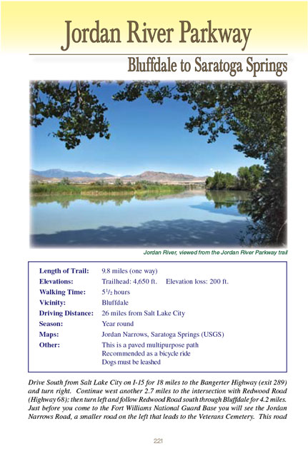
Every part of the Jordan River Parkway Trail is certainly worth exploring, but the Utah County section between Bluffdale and Saratoga Springs is my personal favorite.
The river is much fuller in Utah County because most of the irrigation canals are located further downstream in Salt Lake County. Also the land surrounding the
river in this area is very rural in nature, far removed from the more heavily populated land further north, so you can expect a more peaceful and scenic ride.
An added bonus is that you are also likely to see a lot of water birds along the way-especially during the spring and fall migratory seasons.
Shortly after leaving the Jordan Narrows Trailhead the trail descends about 50 feet to meet a trail junction where another paved path departs on the left. This
is the northern extension of the Jordan River Parkway Trail, but, as mentioned above, it only goes 0.6 mile before coming to a dead end. Bearing right at the junction
the route turns south and loses another 50 feet as it begins following a bench high above the southeast side of the Jordan Narrows. This is a particularly
interesting part of the trail, and there is a lot to see over the next half mile. As you enter the narrows you will see the Jordan Narrows Dam 150 feet below
the trail. This diversion dam was one of the first construction projects of the Mormon pioneers after they arrived in Salt Lake in 1847. Two canals, the Draper
Canal and the East Jordan Canal, can be seen leaving the river on the upstream side of the dam. These are irrigation canals used to carry water to farms on
the bluffs above the east side of the Jordan River.
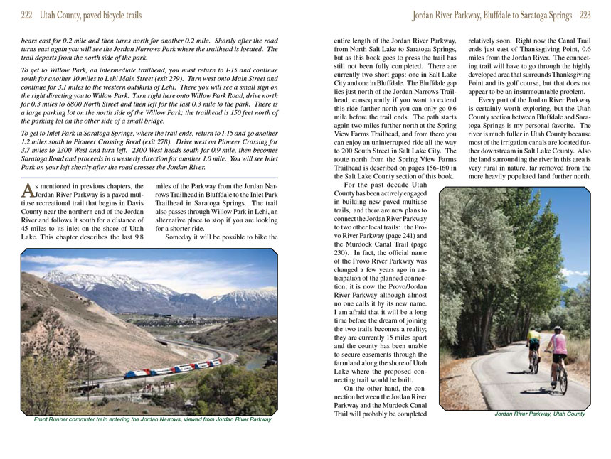
 The railroad tracks that follow the opposite side of the river were originally built by the Union Pacific Railroad, but they are now being used by the Front
Runner commuter trains that carry passengers to the cities along the Wasatch Front. The
Jordan River Parkway Trail also passes below two large wind turbines that are part of the
Utah Army National Guard’s Fort Williams Training Site southwest of the trail. The first turbine was installed in January, 2000, and for a while it was the
only wind-powered electrical generating facility in the state.
The railroad tracks that follow the opposite side of the river were originally built by the Union Pacific Railroad, but they are now being used by the Front
Runner commuter trains that carry passengers to the cities along the Wasatch Front. The
Jordan River Parkway Trail also passes below two large wind turbines that are part of the
Utah Army National Guard’s Fort Williams Training Site southwest of the trail. The first turbine was installed in January, 2000, and for a while it was the
only wind-powered electrical generating facility in the state.
Shortly after passing the wind turbines the
Jordan River Parkway Trail goes through two wide switchbacks as it descends the last 100 feet down to the
river. Upon reaching the water it crosses a footbridge and turns south along the river’s eastern shore. Most of the land on the east side of the river in this
area is owed by the Thanksgiving Point Corporation, and for the next 2.3 miles you will be traveling along the edge of the Thanksgiving Point Golf Course. This
is a very pretty area and an enjoyable ride. The beautiful Thanksgiving Point Botanical Gardens lies just east of the golf course, but unfortunately there is
no convenient way to get to it from the Jordan River Parkway Trail.
Notice how much more water there is in the river upstream from the Jordan Narrows Dam and its canals. Before the dams along the river were built the flow rate
of the Jordan fluctuated a great deal, and fording the river with wagons and horses during times of high runoff was often dangerous. In 1858 a ferry service
was initiated near Thanksgiving Point that made safe year-round crossings possible. The service, called the Indian Ford Ferry, was used by the Pony Express
as well as the Overland Stage Company and other travelers on their way to Oregon and California. For a time the ferry operated day and night, sometimes carrying
as many as 500 people in a single 24-hour period. It only continued for a decade, however; the ferry was disbanded after the completion of the Transcontinental
Railroad in 1869. You will pass the location of the old Indian Ford Ferry 0.5 mile after the
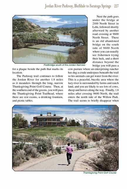
Jordan River Parkway Trail crosses to the east side of the river. Look for a plaque
beside the path that marks its location.
The Jordan River Parkway Trail continues to follow the Jordan River for another 1.8 miles as it meanders through the long, narrow Thanksgiving Point Golf Course. Then, at
the southern end of the greens, you will pass the Thanksgiving Point Trailhead, where there are rest rooms, a drinking fountain, and picnic tables.
 Next the Jordan River Parkway Trail goes under the bridge at 2100 North Street in Lehi, followed shortly afterward by another road crossing at 9600 North Street. There is an old
abandoned bridge on the south side of 9600 North where you can usually see fishermen trying their luck, and a short distance beyond the bridge you will pass
a cow pasture where an enterprising rancher has dug a crude underpass beneath the trail so his animals can get water from the river. This is a peaceful, bucolic
area where the lazy river is surrounded by farms and ranch land, and you are likely to see lots of cows, sheep and horses along the way. Finally, 1.8 miles
after crossing 9600 North, the Jordan River Parkway Trail enters the north side of the Willow Park. The trail seems to briefly disappear when you cross into the park, but
if you continue riding south on the road through the camping area for 300 yards you will see where the trail begins again.
Next the Jordan River Parkway Trail goes under the bridge at 2100 North Street in Lehi, followed shortly afterward by another road crossing at 9600 North Street. There is an old
abandoned bridge on the south side of 9600 North where you can usually see fishermen trying their luck, and a short distance beyond the bridge you will pass
a cow pasture where an enterprising rancher has dug a crude underpass beneath the trail so his animals can get water from the river. This is a peaceful, bucolic
area where the lazy river is surrounded by farms and ranch land, and you are likely to see lots of cows, sheep and horses along the way. Finally, 1.8 miles
after crossing 9600 North, the Jordan River Parkway Trail enters the north side of the Willow Park. The trail seems to briefly disappear when you cross into the park, but
if you continue riding south on the road through the camping area for 300 yards you will see where the trail begins again.
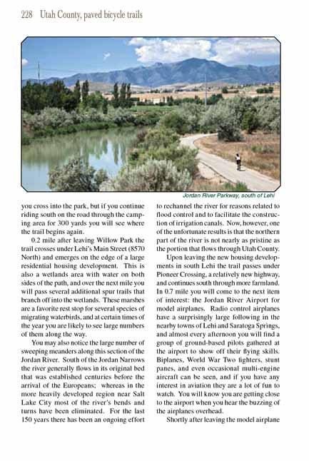
0.2 mile after leaving Willow Park the Jordan
River Parkway Trail crosses under Lehi’s Main Street (8570 North) and emerges on the edge of a large
residential housing development. This is also a wetlands area with water on both sides of the path, and over the next mile you will pass several additional
spur trails that branch off into the wetlands. These marshes are a favorite rest stop for several species of migrating waterbirds, and at certain times of
the year you are likely to see large numbers of them along the way.
You may also notice the large number of sweeping meanders along this section of the Jordan River. South of the Jordan Narrows the river generally flows in
its original bed that was established centuries before the arrival of the Europeans; whereas in the more heavily developed region near Salt Lake City most
of the river’s bends and turns have been eliminated. For the last 150 years there has been an ongoing effort to rechannel the river for reasons related to
flood control and to facilitate the construction of irrigation canals. Now, however, one of the unfortunate results is that the northern part of the river
is not nearly as pristine as the portion that flows through Utah County.
 Upon leaving the new housing developments in south Lehi the
Jordan River Parkway Trail passes under Pioneer Crossing, a relatively new highway, and continues south through more
farmland. In 0.7 mile you will come to the next item of interest: the Jordan River Airport for model airplanes. Radio control airplanes have a surprisingly
large following in the nearby towns of Lehi and Saratoga Springs, and almost every afternoon you will find a group of ground-based pilots gathered at the airport
to show off their flying skills. Biplanes, World War Two fighters, stunt panes, and even occasional multi-engine aircraft can be seen, and if you have any
interest in aviation they are a lot of fun to watch. You will know you are getting close to the airport when you hear the buzzing of the airplanes overhead.
Upon leaving the new housing developments in south Lehi the
Jordan River Parkway Trail passes under Pioneer Crossing, a relatively new highway, and continues south through more
farmland. In 0.7 mile you will come to the next item of interest: the Jordan River Airport for model airplanes. Radio control airplanes have a surprisingly
large following in the nearby towns of Lehi and Saratoga Springs, and almost every afternoon you will find a group of ground-based pilots gathered at the airport
to show off their flying skills. Biplanes, World War Two fighters, stunt panes, and even occasional multi-engine aircraft can be seen, and if you have any
interest in aviation they are a lot of fun to watch. You will know you are getting close to the airport when you hear the buzzing of the airplanes overhead.
Shortly after leaving the model airplane airport the
Jordan River Parkway Trail crosses Saratoga Road and then crosses a footbridge to the west side of the
river. At this point the trail is only 400 yards from Utah Lake. If you look upriver to the southeast you will see a dam at the river’s northern inlet, and a short
distance later the trail passes another dam at the river’s southern inlet. The Jordan River is Utah Lake’s only outlet, and although it is a natural lake it serves
as a water storage reservoir for the extensive system of irrigation canals that have been built along the lower reaches of the river.
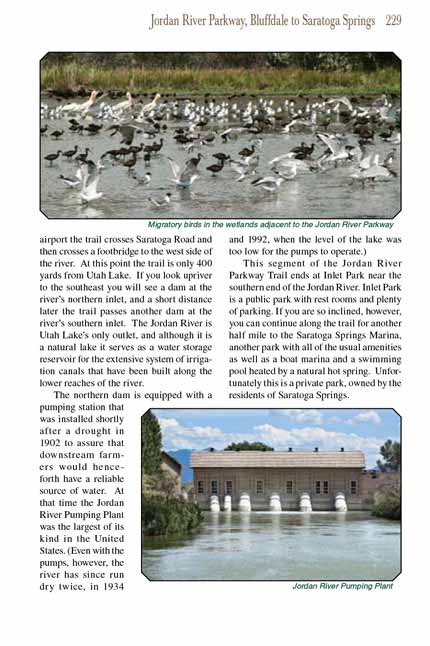
The northern dam is equipped with a pumping station that was installed shortly after a drought in 1902 to assure that downstream farmers would henceforth have a
reliable source of water. At that time the Jordan River Pumping Plant was the largest of its kind in the United States. (Even with the pumps, however, the river
has since run dry twice, in 1934 and 1992, when the level of the lake was too low for the pumps to operate.)
This segment of the Jordan River Parkway Trail ends at Inlet Park near the southern end of the Jordan River. Inlet Park is a public park with rest rooms and plenty
of parking. If you are so inclined, however, you can continue along the trail for another half mile to the Saratoga Springs Marina, another park with all of the
usual amenities as well as a boat marina and a swimming pool heated by a natural hot spring. Unfortunately this is a private park, owned by the residents of
Saratoga Springs.
Note to web developers: You may copy this material onto your site, but in return please include a link to my home page
www.utahtrails.com. Thank you, David Day (utahdavidday
at gmail.com)
Click here to see more
trails near Salt Lake City
© Rincon Publishing Company, all rights reserved
|