Kay's Creek Parkway Trail
excerpted from our book
Salt Lake City's Incredible Hiking and Biking Trails
pages 282-284
|
Buy book directly from the author!
Salt Lake City's Incredible Hiking and Biking Trails
- has access info for 73 trailheads
- 73 colorful trail maps
- 325 full color photographs
- loads of hiking tips
|
regularly $19.95
now on sale for only
$9.95
click here
for book orders
|
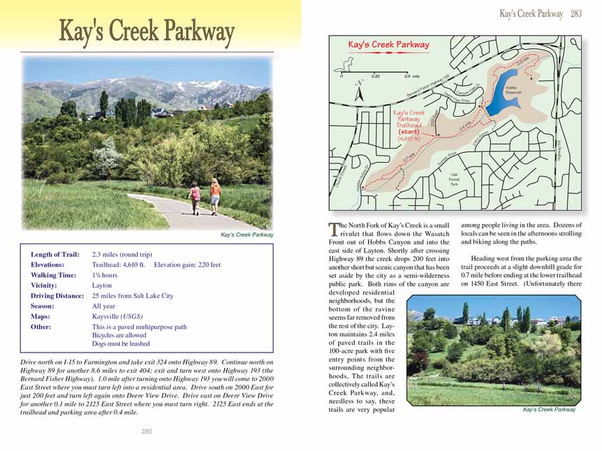
The North Fork of Kay’s Creek is a small rivulet that flows down the
Wasatch Front out of Hobbs Canyon and into the east side of Layton. Shortly
after crossing Highway 89 the creek drops 200 feet into another short but
scenic canyon that has been set aside by the city as a semi-wilderness public
park. Both rims of the canyon are developed residential neighborhoods, but the
bottom of the ravine seems far removed from the rest of the city. Layton
maintains 2.4 miles of paved trails in the 100-acre park with five entry points
from the surrounding neighborhoods, The trails are collectively called Kay’s
Creek Parkway, and, needless to say, these trails are very popular among people
living in the area. Dozens of locals can be seen in the afternoons strolling
and biking along the Kays Creek Parkway trails.
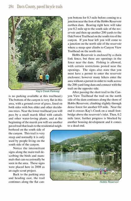
Heading west from the parking area the
primary Kays Creek Parkway trail proceeds at a slight downhill grade for 0.7 mile before ending at the lower trailhead on 1450 East Street.
(Unfortunately there is no parking available at this trailhead.) The bottom of the canyon is very flat in this area, with a ground cover of grass,
lined on both sides with box elder and other deciduous trees. Near the lower trailhead you will pass by a small marsh filled with cattails and other
water-loving plants, and at the beginning of the marsh you will see another paved trail that leads to the residential neighborhood on the south side
of the canyon. This trail is very steep and normally it is only used by people living on the south side of the canyon.
Notice the intermittent signs along the Kays
Creek Parkway trail describing the birds and mammals that can occasionally be seen in the area. These signs were placed
here in 2008 as an eagle scout project.
Back to the parking area and heading east, the
Kays Creek Parkway trail continues along the flat canyon bottom for 0.3 mile before coming to a junction near the foot of the
Hobbs Reservoir earthen dam. Bearing right here will take you 0.2 mile up to the south side of the reservoir and then up another 200 yards to the Oak
Forest Trailhead on the south rim of the canyon. If you bear left you will come to a junction on the north side of the reservoir where a steep spur
climbs to Canyon View Trailhead on the north rim.
Hobbs Reservoir is enclosed by a chain link fence, but there are openings in the fence near the dam. Fishing is allowed, with certain restrictions
posted near the openings. The signs also state that you must have a permit to enter the reservoir enclosure; however many hikers enter the area without
a permit in order to walk across the 200-yard-long dam and connect with the trail on the opposite side.
After passing the short trail to the Canyon View Trailhead the
Kays Creek Parkway trail on the north side of the dam continues along the shore of Hobbs Reservoir, climbing
slightly through dense forest for another 0.9 mile. Near the end it crosses Kay’s Creek on a small footbridge above the reservoir’s inlet. Then,
0.2 mile later, further progress is blocked by another housing development and it comes to a dead end.
Note to web developers: You may copy this material onto your site, but in return please include a link to my home page
www.utahtrails.com. Thank you, David Day (utahdavidday at gmail.com)
Click here to see more
trails near Salt Lake City
© Rincon Publishing Company, all rights reserved
|