Mount Aire Trail
excerpted from our book
Salt Lake City's Incredible Hiking and Biking Trails
pages 46-48
|
Buy book directly from the author!
Salt Lake City's Incredible Hiking and Biking Trails
- has access info for 73 trailheads
- 73 colorful trail maps
- 325 full color photographs
- loads of hiking tips
|
regularly $19.95
now on sale for only
$9.95
click here
for book orders
|
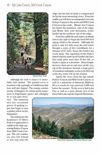
Mount Aire is one of the easiest peaks near Salt Lake City to climb, but that is not to say that it won’t require some effort.
The summit is only 1.7 miles from the trailhead, but within that short distance you must climb nearly 2,000 feet. The
Mount Aire trail climbs relentlessly; however
it is well maintained and with persistence you shouldn’t have any trouble completing the assent. Although a lot of uphill walking is involved there are
no outrageously steep sections and no serious obstacles-just a long, grueling uphill grind.
For the first 0.8 mile you will be following the eastern side of Elbow Fork, a tiny tributary of Mill Creek that drains the southern slopes of Mount Aire. The
flow rate of Elbow Fork is miniscule, and unless there has been a recent rain you may not even know it is there. 0.2 mile from the trailhead you will come to
a signed trail junction where the Lambs Canyon Trail branches off to the right. Bear left here, continuing along the east side of Elbow Fork. Less than a
minute beyond the Lambs Canyon trail junction the Mount Aire trail crosses the drainage on a small footbridge, then 200 yards further, as it begins a long bend
to the west, it crosses another wooden bridge. After the second crossing the trail starts climbing at a steeper grade that continues for most of the next 0.6
mile.
Although the trail is steep it is mercifully well shaded. The ground cover is luxuriant with a panoply of wildflowers that lasts well into August. The canopy
consists mostly of Douglass fir, which slowly transitions to Engelmann spruce and subalpine fir as you gain elevation. The mountain also has occasional groves
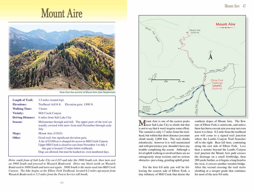
of quaking aspen that begin to turn a golden yellow in late September.
The Mount Aire trail passes the headwaters of Elbow Fork as it approaches a saddle in the ridge separating Parleys Canyon from Mill Creek Canyon. The tall conifers are also
left behind as you step onto the ridge, but the lack of shade is compensated for by the more interesting views. From the saddle you will have an unimpeded view
into Parleys Canyon to the north and Mill Creek Canyon to the south. Mount Aire Canyon lies below the northwest side of the ridge, and Mount Aire, your
destination, looms further up the northeast side of the ridge.
From the saddle the Mount Aire trail makes an abrupt turn to the right to begin the final 840-foot zigzag climb to the summit. Although the peak is only 0.3 mile away the
trail winds through a series of five switchbacks for a distance of 0.7 mile; hence the climb is not overly steep. The vegetation on the slope is almost entirely
made up of Gambel oak trees that rarely grow more than 10 feet tall, so shade is again at a premium. Interestingly, however, there are no oak trees on the very
top of Mount Aire. Instead, a large grove of mountain mahogany seems to be thriving in the dry, rocky soil on the summit.
Again, the views from the top of Mount Aire include Parleys Canyon and Mill Creek Canyon, as well as a panorama of Interstate Highway 80 as it winds it's way eastward 2,000
feet below the summit. To the west is Salt Lake City as well as a more distant view of the Great Salt Lake and the Oquirrh Mountains.
Note to web developers: You may copy this material onto your site, but in return please include a link to my home page
www.utahtrails.com. Thank you, David Day (utahdavidday
at gmail).com
Click here to see more
trails near Salt Lake City
© Rincon Publishing Company, all rights reserved
|