Mount Raymond
via Bowman Fork Trail
excerpted from our book
Salt Lake City's Incredible Hiking and Biking Trails
pages 42-45
|
Buy book directly from the author!
Salt Lake City's Incredible Hiking and Biking Trails
- has access info for 73 trailheads
- 73 colorful trail maps
- 325 full color photographs
- loads of hiking tips
|
regularly $19.95
now on sale for only
$9.95
click here
for book orders
|
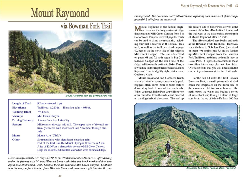
 Mount Raymond is the second highest peak on the long east-west ridge that separates Mill Creek Canyon from Big Cottonwood Canyon.
Several popular trails can be used to climb Mount Raymond, including four that I describe in this book. This trail, as well as the trail described on page 49,
begins on the north side of the ridge in Mill Creek Canyon. The trails described on pages 68 and 72 both begin in Big Cottonwood Canyon on the south side of
the ridge. All four trails go first to Baker Pass, a low saddle on the ridge that separates Mount Raymond from its slightly higher sister peak, Gobblers Knob.
Mount Raymond is the second highest peak on the long east-west ridge that separates Mill Creek Canyon from Big Cottonwood Canyon.
Several popular trails can be used to climb Mount Raymond, including four that I describe in this book. This trail, as well as the trail described on page 49,
begins on the north side of the ridge in Mill Creek Canyon. The trails described on pages 68 and 72 both begin in Big Cottonwood Canyon on the south side of
the ridge. All four trails go first to Baker Pass, a low saddle on the ridge that separates Mount Raymond from its slightly higher sister peak, Gobblers Knob.
Mount Raymond and Gobblers Knob are only 1.4 miles apart; consequently peak baggers often climb both of them before descending back to one of the trailheads.
When you reach Baker Pass you will see two other trails that leave the saddle and proceed up the ridge in both directions. The trail up the eastern side of
Baker Pass arrives at the summit of Gobblers Knob after 0.8 mile, and the trail west of the pass ends at the summit of Mount Raymond after 0.6 mile.
The hike described here begins and ends at the Bowman Fork Trailhead. However, since the hike to Gobblers Knob (described on page 49) begins just 3.4 miles
further up Mill Creek Canyon from the Bowman Fork Trailhead, and since both trails meet at Baker Pass, it is possible to combine these two hikes into a very
pleasant loop hike. Of course to do that you will need a shuttle car or bicycle to connect the two trailheads.
For the first 1.1 miles the Mount Raymond trail follows Bowman Fork, a small, pleasantly shaded creek that originates on the north side of the mountain. All too soon,
however, the path leaves the water and begins a series of switchbacks up through a stand of large conifers to the top of White Fir Pass, 600 feet above Bowman
Fork. Once you reach the top of White Fir Pass the forest becomes less dense, and the
Mount Raymond trail settles down to a more gradual climb. Soon you will see Mount
Raymond looming through the quaking aspen, and shortly after that you will see a trail to Alexander Basin departing on the left. Continuing upward for another
0.4 mile beyond the trail junction will bring you to Baker Spring, the next point of interest.
Thirty years ago there was an historic cabin at Baker Spring, used by workers that once operated a nearby mine. Unfortunately the cabin burned down in the 1980s,
and today there is scarcely a trace of the building or the mine. Gobblers Knob is said to have been named after a flock of loud turkeys that the miners kept near
the cabin.
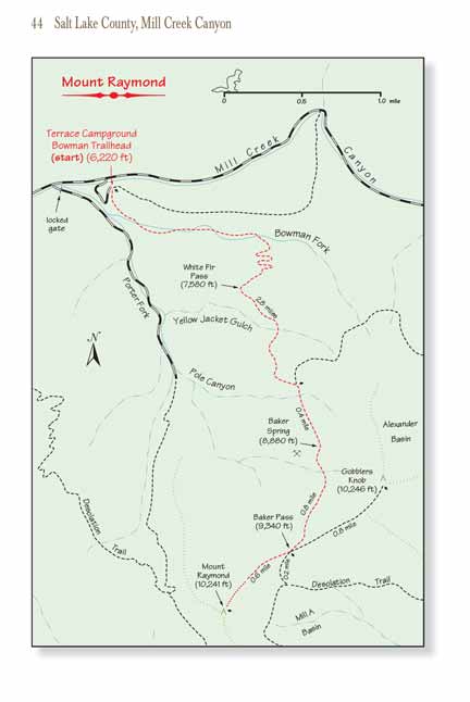
As you leave Baker Spring the forest opens up to some fine views of both Mount Raymond and Gobblers Knob. Then after 0.8 mile you will arrive at Baker Pass,
where another magnificent panorama of the Twin Peaks Wilderness Area south of Big Cottonwood Canyon awaits you.
When you reach the pass you will see the two secondary trails that ascend the ridge toward Gobblers Knob on the left and Mount Raymond on the right. It is a
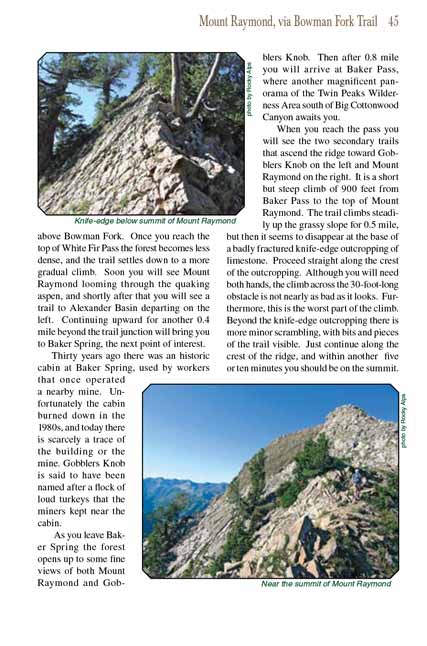
short but steep climb of 900 feet from Baker Pass to the top of Mount Raymond. The trail climbs steadily up the grassy slope for 0.5 mile, but then it seems
to disappear at the base of a badly fractured knife-edge outcropping of limestone. Proceed straight along the crest of the outcropping. Although you will
need both hands, the climb across the 30-foot-long obstacle is not nearly as bad as it looks. Furthermore, this is the worst part of the climb. Beyond the
knife-edge outcropping there is more minor scrambling, with bits and pieces of the trail visible. Just continue along the crest of the ridge, and within
another five or ten minutes you should be on the summit of Mount Raymond.
Note to web developers: You may copy this material onto your site, but in return please include a link to my home page
www.utahtrails.com. Thank you, David Day (utahdavidday
at gmail).com
Click here to see more
trails near Salt Lake City
© Rincon Publishing Company, all rights reserved
|