Murdock Canal Trail
Highland to Orem
excerpted from our book
Salt Lake City's Incredible Hiking and Biking Trails
pages 230-235
|
Buy book directly from the author!
Salt Lake City's Incredible Hiking and Biking Trails
- has access info for 73 trailheads
- 73 colorful trail maps
- 325 full color photographs
- loads of hiking tips
|
regularly $19.95
now on sale for only
$9.95
click here
for book orders
|

 Before 2010 the Murdock Canal was a large earthen ditch used to transport irrigation water from the Provo River to farms and
ranches north along the Wasatch Front. When the structure was built in the early 1900s it was called the Provo Reservoir Canal; then in the 1940s it was
enlarged by the Bureau of Reclamation and subsequently renamed the Murdock Canal.
Before 2010 the Murdock Canal was a large earthen ditch used to transport irrigation water from the Provo River to farms and
ranches north along the Wasatch Front. When the structure was built in the early 1900s it was called the Provo Reservoir Canal; then in the 1940s it was
enlarged by the Bureau of Reclamation and subsequently renamed the Murdock Canal.
In 2010 a decision was made to replace the Murdock Canal with a 21-mile underground aqueduct, and a related plan was put forward to build a paved recreational
trail along the easement above the pipeline. The plan was implemented with the help of federal stimulus money, and in May, 2013, the Murdock Canal Trail was
officially opened to the public. At the time of this printing the paved multiuse path extends for 17 miles from Lehi through Cedar Hills, Highland, American
Fork, Pleasant Grove, and Lindon to Orem.
The Murdock Canal Trail ends at 800 North Street in Orem, but from there it is possible to access the Provo River Parkway Trail (see page 236). The two trails are just
0.7 mile apart, and the city of Orem has constructed a bike path along the north side of 800 North Street that can be used as a connecting trail.
The northern end of the Murdock Canal Trail ends in Lehi just one mile east of the Jordan River Parkway. Someday the two trails will undoubtedly be connected,
but at the time of this printing it looks like that goal is still years away.
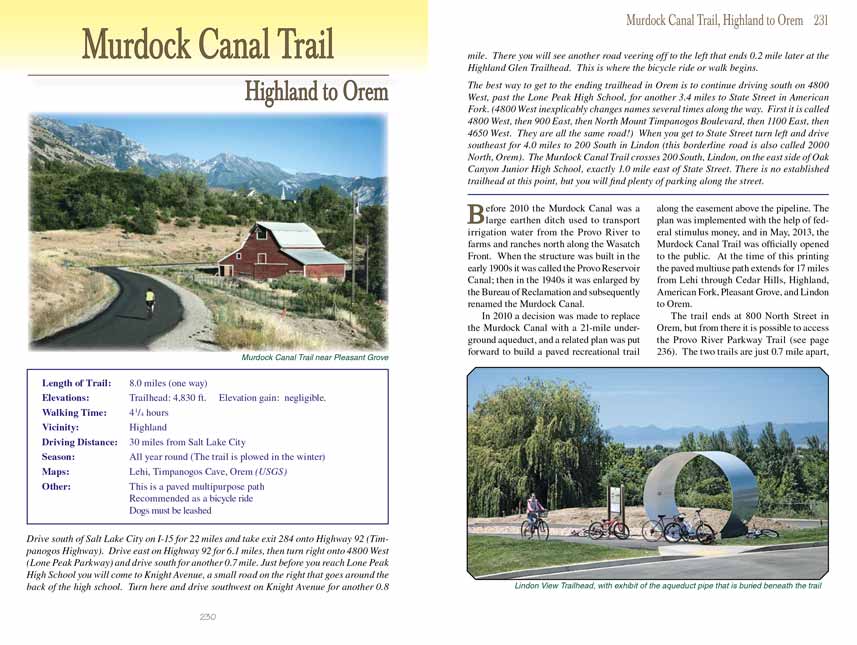
In this chapter I will describe the eight-mile segment of the Murdock Canal Trail that runs from Highland to the northern boundary of Orem. In my opinion
this is the most interesting part of the trail. It is very rural in nature, passing farms and horse corrals with gorgeous views of the mountains and long
stretches that overlook the valley below.
The trail begins by leaving Highland Glen Trailhead in a southerly direction, but before starting you may want to ride or walk down the narrow road on the
west side of the trailhead into Highland Glen Park. There are many additional paths to explore in this small but interesting semi-wilderness park,
including one that goes around a large fishing pond on the park’s north side. Highland Glen Park is also the starting point for the Highland Trail,
another paved bicycle path goes north past the Alpine Country Club Golf Course and then east to join the Cedar Hills network of paved multiuse trails.
 Just 250 feet after leaving the trailhead on the Murdock Canal Trail you will come to a junction where the Art Dye Trail
departs on the right. This side trail continues south along the east side of the Fox Hollow Golf Course for 0.8 mile before entering Art Dye Park. The
Murdock Canal Trail makes a hard left turn at the junction and abruptly splits into two parallel paths, one for bicycles and one for pedestrians. The two paths
then continue, side-by-side, through the middle of a large agricultural field for 0.5 mile before crossing under 4800 West Street into American Fork.
Just 250 feet after leaving the trailhead on the Murdock Canal Trail you will come to a junction where the Art Dye Trail
departs on the right. This side trail continues south along the east side of the Fox Hollow Golf Course for 0.8 mile before entering Art Dye Park. The
Murdock Canal Trail makes a hard left turn at the junction and abruptly splits into two parallel paths, one for bicycles and one for pedestrians. The two paths
then continue, side-by-side, through the middle of a large agricultural field for 0.5 mile before crossing under 4800 West Street into American Fork.
The Murdock Canal Trail continues east for another half mile through American Fork before crossing the city’s eastern boundary into the town of Pleasant Grove. In American
Fork you will be passing through a residential area with houses on both sides of the trail, but in Pleasant Grove the surroundings are once again more rural.
The route stays in Pleasant Grove for most of the remainder of the ride, and, in my opinion, this section is the most interesting part of the
Murdock Canal Trail.
Another half mile will bring you to the next road crossing at 900 West Street, and beyond that point the
Murdock Canal Trail begins a long sweeping turn to the south as
it approaches the foothills on the eastern side of the city. After completing the turn the path dips into a tunnel under Highway 146, and when you emerge
on the east side of the highway you will see the Canyon Road Trailhead on your left. Public restrooms and a drinking fountain are available at the trailhead.
As you proceed south you will soon be threading your way along the western side of the boundary between Pleasant Grove and the Uinta National Forest. The
Murdock Canal Trail is 200 feet above the valley floor in this area, and it meticulously follows the contour of the foothills in an effort to avoid any changes in elevation.
 This section of trail above Pleasant Grove is a delightful bicycle ride, but unfortunately it only lasts for about a mile.
Soon the city rises to meet the path, and you will arrive at 1100 North Street where there is another road crossing. This is also the location of the Wade
Springs Trailhead where, again, you will find public restrooms and a drinking fountain.
This section of trail above Pleasant Grove is a delightful bicycle ride, but unfortunately it only lasts for about a mile.
Soon the city rises to meet the path, and you will arrive at 1100 North Street where there is another road crossing. This is also the location of the Wade
Springs Trailhead where, again, you will find public restrooms and a drinking fountain.
Beyond 1100 North Street the trail proceeds through an area that is more residential in nature; nevertheless it still has a lot to offer. There are many small
farms and horse pastures interspersed among the houses, and the mountains east of the
Murdock Canal Trail continue to provide gorgeous views. The trail crosses five more
roads over the next 2.1 miles before leaving Pleasant Grove at 1000 South Street and entering Lindon.
The last 1.7 miles of the trail through Lindon are similar to the trail through south Pleasant Grove. This part of Lindon was almost all farmland only two
decades ago, but now it is semi-residential with just a few small farms. 0.9 mile after crossing into Lindon you will pass the Lindon View Trailhead, again
with restrooms and a drinking fountain; then, 0.3 mile later, you will come to an intersection where the Lindon Heritage Trail crosses the Canal Trail.
The Heritage Trail is an older equestrian trail that runs for several miles through the heart of Lindon.
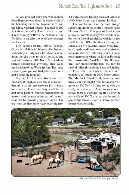
This bike ride ends at the northern boundary of Orem on 2000 North Street. The Murdock Canal Trail, however, continues south through Orem for another 2.3
miles to 800 North Street, so the ride can easily be extended. Also, as mentioned above, there is a connecting trail along the north side of 800 North that
can be used to access the Provo River Parkway, so even longer rides possible.
Note to web developers: You may copy this material onto your site, but in return please include a link to my home page
www.utahtrails.com. Thank you, David Day (utahdavidday
at gmail.com)
Click here to see more
trails near Salt Lake City
© Rincon Publishing Company, all rights reserved
|