Ogden River Parkway Trail
excerpted from our book
Salt Lake City's Incredible Hiking and Biking Trails
pages 296-301
|
Buy book directly from the author!
Salt Lake City's Incredible Hiking and Biking Trails
- has access info for 73 trailheads
- 73 colorful trail maps
- 325 full color photographs
- loads of hiking tips
|
regularly $19.95
now on sale for only
$9.95
click here
for book orders
|
 The city of Ogden, located just east of the confluence where the Ogden River meets the Weber River, holds the distinction
of being Utah’s oldest city. It was first founded in 1845 by a fur trapper named Miles Goodyear and then sold two years later to the newly arrived Mormon
settlers. The Mormons soon began building farms along the banks of the Ogden and Weber Rivers, and later their town came to known as Ogden. The town and
the river were named after a Canadian trapper named Peter Skene Ogden who trapped in the area in the late 1820s and was probably the first European to see
the Ogden River.
The city of Ogden, located just east of the confluence where the Ogden River meets the Weber River, holds the distinction
of being Utah’s oldest city. It was first founded in 1845 by a fur trapper named Miles Goodyear and then sold two years later to the newly arrived Mormon
settlers. The Mormons soon began building farms along the banks of the Ogden and Weber Rivers, and later their town came to known as Ogden. The town and
the river were named after a Canadian trapper named Peter Skene Ogden who trapped in the area in the late 1820s and was probably the first European to see
the Ogden River.
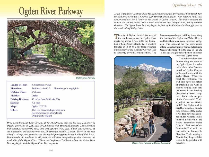
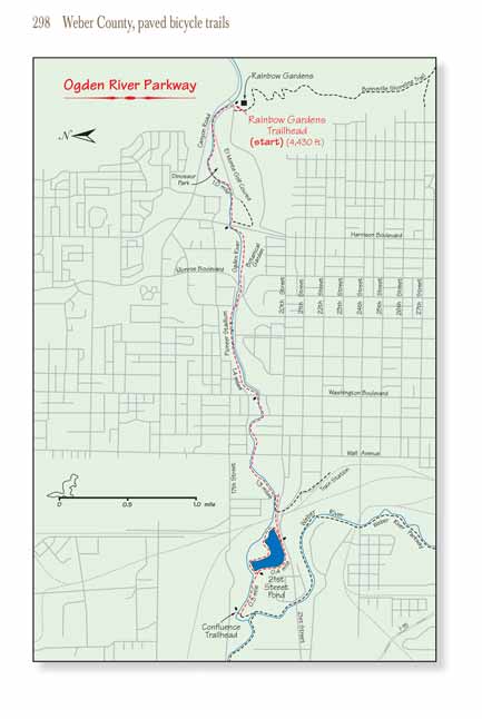
The Ogden River Parkway Trail described here follows along the shore of the Ogden River for a distance of 4.4 miles from the mouth of Ogden Canyon to the confluence with the Weber
River. When you reach the confluence you will also have the option of extending you walk or ride by turning south onto the Weber River Parkway (described in
the next chapter). Both trails are part of the Centennial Trail, a project that was started in 1991 by Ogden and its neighboring cities. To date only 5.2
miles of the Weber River Trail have been completed, but when the trail is finished it will run all the way to the mouth of Weber Canyon. Both ends of the
Centennial Trail will connect with the Bonneville Shoreline Trail, making a 30-mile-long loop trail that is sure to be popular with bicyclers!
Upon leaving the Rainbow Gardens Trailhead the
Ogden River Parkway Trail follows the side of Park Road for the first 0.4 mile; then it veers north around the backside of the
Eccles Dinosaur Park. This interesting park covers an area of over eight acres, and it is filled with dozens of life sized replicas of animals from the
Jurassic Period. Many of the fierce creatures can be seen along the trail on the other side of the museum fence. 0.4 mile later the
Ogden River Parkway Trail returns to
Park Boulevard and briefly skirts the side of Lions Park before following the river under Harrison Boulevard.
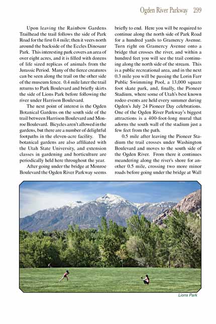
The next point of interest is the Ogden Botanical Gardens on the south side of the trail between Harrison Boulevard and Monroe Boulevard. Bicycles aren’t
allowed in the gardens, but there are a number of delightful footpaths in the eleven-acre facility. The botanical gardens are also affiliated with the
Utah State University, and extension classes in gardening and horticulture are periodically held here throughout the year.
 After going under the bridge at Monroe Boulevard the Ogden River Parkway
Trail seems briefly to end. Here you will be required to
continue along the north side of Park Road for a hundred yards to Gramercy Avenue. Turn right on Gramercy Avenue onto a bridge that crosses the river, and
within a hundred feet you will see the Ogden River Parkway Trail continuing along the north side of the stream. This is a public recreational area, and in the next 0.3 mile
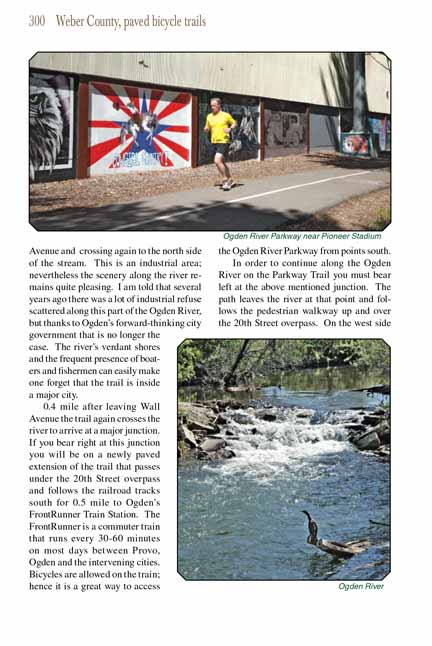
you will be passing the Lorin Farr Public Swimming Pool, a 13,000 square foot skate park, and, finally, the Pioneer Stadium, where some of Utah’s best
known rodeo events are held every summer during Ogden’s July 24 Pioneer Day celebrations. One of the Ogden River Parkway’s biggest attractions is a
400-foot-long mural that adorns the south wall of the stadium just a few feet from the path.
After going under the bridge at Monroe Boulevard the Ogden River Parkway
Trail seems briefly to end. Here you will be required to
continue along the north side of Park Road for a hundred yards to Gramercy Avenue. Turn right on Gramercy Avenue onto a bridge that crosses the river, and
within a hundred feet you will see the Ogden River Parkway Trail continuing along the north side of the stream. This is a public recreational area, and in the next 0.3 mile
you will be passing the Lorin Farr Public Swimming Pool, a 13,000 square foot skate park, and, finally, the Pioneer Stadium, where some of Utah’s best
known rodeo events are held every summer during Ogden’s July 24 Pioneer Day celebrations. One of the Ogden River Parkway’s biggest attractions is a
400-foot-long mural that adorns the south wall of the stadium just a few feet from the path.
0.5 mile after leaving the Pioneer Stadium the
Ogden River Parkway Trail crosses under Washington Boulevard and moves to the south side of the Ogden River. From there it
continues meandering along the river's shore for another 0.5 mile, crossing two more minor roads before going under the bridge at Wall Avenue and crossing
again to the north side of the stream. This is an industrial area; nevertheless the scenery along the river remains quite pleasing. I am told that several
years ago there was a lot of industrial refuse scattered along this part of the Ogden River, but thanks to Ogden’s forward-thinking city government that is
no longer the case. The river’s verdant shores and the frequent presence of boaters and fishermen can easily make one forget that the trail is inside a
major city.
0.4 mile after leaving Wall Avenue the Ogden
River Parkway Tail again crosses the river to arrive at a major junction. If you bear right at this junction you will be on a newly
paved extension of the trail that passes under the 20th Street overpass and follows the railroad tracks south for 0.5 mile to Ogden’s FrontRunner Train Station.
The FrontRunner is a commuter train that runs every 30-60 minutes on most days between Provo, Ogden and the intervening cities. Bicycles are allowed on the
train; hence it is a great way to access the Ogden River Parkway Trail from points south.
In order to continue along the Ogden River on the Parkway Trail you must bear left at the above mentioned junction. The path leaves the river at that point
and follows the pedestrian walkway up and over the 20th Street overpass. On the west side of the overpass the trail veers to the north and soon you will
find yourself on the south side of the 21st Street Pond. This delightful 39-acre pond should be a centerpiece of Ogden’s city park system. Unfortunately,
however, the pond has been the subject of considerable political skullduggery over the past decade, and now it is not clear if fishing or boating or even
dipping your feet in the water is entirely legal.
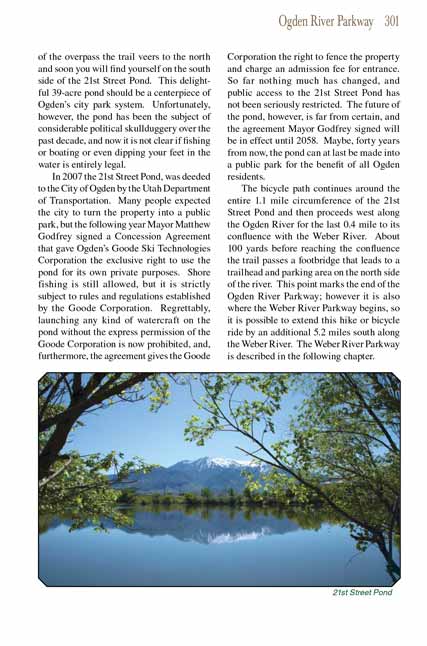 In 2007 the 21st Street Pond, was deeded to the City of Ogden by the Utah Department of Transportation. Many people expected
the city to turn the property into a public park, but the following year Mayor Matthew Godfrey signed a Concession Agreement that gave Ogden’s Goode Ski
Technologies Corporation the exclusive right to use the pond for its own private purposes. Shore fishing is still allowed, but it is strictly subject to
rules and regulations established by the Goode Corporation. Regrettably, launching any kind of watercraft on the pond without the express permission of
the Goode Corporation is now prohibited, and, furthermore, the agreement gives the Goode Corporation the right to fence the property and charge an
admission fee for entrance. So far nothing much has changed, and public access to the 21st Street Pond has not been seriously restricted. The future
of the pond, however, is far from certain, and the agreement Mayor Godfrey signed will be in effect until 2058. Maybe, forty years from now, the pond
can at last be made into a public park for the benefit of all Ogden residents.
In 2007 the 21st Street Pond, was deeded to the City of Ogden by the Utah Department of Transportation. Many people expected
the city to turn the property into a public park, but the following year Mayor Matthew Godfrey signed a Concession Agreement that gave Ogden’s Goode Ski
Technologies Corporation the exclusive right to use the pond for its own private purposes. Shore fishing is still allowed, but it is strictly subject to
rules and regulations established by the Goode Corporation. Regrettably, launching any kind of watercraft on the pond without the express permission of
the Goode Corporation is now prohibited, and, furthermore, the agreement gives the Goode Corporation the right to fence the property and charge an
admission fee for entrance. So far nothing much has changed, and public access to the 21st Street Pond has not been seriously restricted. The future
of the pond, however, is far from certain, and the agreement Mayor Godfrey signed will be in effect until 2058. Maybe, forty years from now, the pond
can at last be made into a public park for the benefit of all Ogden residents.
The bicycle path continues around the entire 1.1 mile circumference of the 21st Street Pond and then proceeds west along the Ogden River for the last 0.4
mile to its confluence with the Weber River. About 100 yards before reaching the confluence the
Ogden River Parkway Trail passes a footbridge that leads to a trailhead and
parking area on the north side of the river. This point marks the end of the Ogden River Parkway
Trail; however it is also where the Weber River Parkway begins,
so it is possible to extend this hike or bicycle ride by an additional 5.2 miles south along the Weber River. The Weber River Parkway is described in the
following chapter.
Note to web developers: You may copy this material onto your site, but in return please include a link to my home page
www.utahtrails.com. Thank you, David Day (utahdavidday at gmail.com)
Click here to see more
trails near Salt Lake City
© Rincon Publishing Company, all rights reserved
|