Summit Park Peak Trail
excerpted from our book
Salt Lake City's Incredible Hiking and Biking Trails
pages 323-326
|
Buy book directly from the author!
Salt Lake City's Incredible Hiking and Biking Trails
- has access info for 73 trailheads
- 73 colorful trail maps
- 325 full color photographs
- loads of hiking tips
|
regularly $19.95
now on sale for only
$9.95
click here
for book orders
|
 Most of the trails above Summit Park, Utah, were made possible by the generosity of an environmentally minded developer named
Harrison Gentry who, in the late 1990s, placed a conservation easement on 325 acres of his land in Summit Park. He then donated it to the Utah Division of
Forestry, and a short time later the state was able to secure federal financing to help restore the land and build a network recreational trails. The trails
were opened to the public in 2001, and a few years later a non-profit organization called Basin Recreation began a project to further improve and expand the
trails. The Summit Park Trail system we know today was completed in 2008.
Most of the trails above Summit Park, Utah, were made possible by the generosity of an environmentally minded developer named
Harrison Gentry who, in the late 1990s, placed a conservation easement on 325 acres of his land in Summit Park. He then donated it to the Utah Division of
Forestry, and a short time later the state was able to secure federal financing to help restore the land and build a network recreational trails. The trails
were opened to the public in 2001, and a few years later a non-profit organization called Basin Recreation began a project to further improve and expand the
trails. The Summit Park Trail system we know today was completed in 2008.
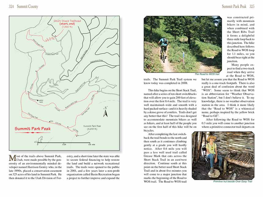
The Summit Park Peak hike begins on the Short Stack Trail, named after a series of ten short switchbacks that will allow you to gain 200 feet of elevation over the first 0.4
mile. The trail is very well maintained-wide and smooth with a hard packed surface-and it is heavily shaded by a dense grove of conifers. Trails don’t get
any better that this! The trail was designed to accommodate mountain bikers as well as hikers, and at least half of the people you see on the first half of
this hike will be on bicycles.
After completing the last switchback the
Summit Park Peak Trail bends to the north and then south as it continues climbing gently at a grade you will hardly notice. After 0.6
mile you will pass a less well used trail called Grease Mark that cuts across the Short Stack Trail in an east/west direction. Continue south at this point on
the better used Short Stack Trail and in about five minutes you will come to a major junction that marks the beginning of the Road to WOS trail. The Road to
WOS trail was constructed primarily with mountain bikers in mind, and when combined with the Short Ribs Trail it forms a delightful three-mile loop back to this
junction. The Summit Park Peak hike described here follows the Road to WOS loop for 1.1 miles, so you should bear right at the junction.
Many people expect to find a two-track road when they arrive at the Road to WOS, but let me assure you that the Road to WOS really is a one-track footpath.
There is also a great deal of confusion about the word “WOS”. Some seem to think that WOS is an abbreviation for “Weather Observation Station”, but I don’t
believe it. To my knowledge, there is no weather observation station in the area. I think it more likely that the “Road to WOS” is a whimsical name, perhaps
inspired by the yellow brick “Road to OZ”.
After following the Road to WOS for 0.3 mile
the Summit Park Peak trail comes to another junction where a primitive connector trail departs on the right toward the Over Easy Trail.
This will be your return route after your climb to the top of Summit Park Peak, but for now you should continue straight ahead along the Road to WOS. There is
also a jeep road below the trail in this area that leads to a water tank a hundred yards further up the trail.
The Road to WOS continues to wind eastward along the side of the mountain with very little change in elevation for the next 0.8 mile before coming to a signed
junction with the Over Easy Trail. This is where you part company with the bikers. Turn right onto the more primitive Over Easy Trail and begin climbing away
from the Road to WOS in a southerly direction. Soon you will begin to see your destination, Summit Park Peak, above the south side of the trail. After climbing
500 feet over the next 0.5 mile you will come to another junction where the
Summit Park Peak trail departs on the left. Turn here and continue climbing the last 200
feet to the summit.
Summit Park Peak lies on the ridge that separates Salt Lake County from Summit County. It is not the highest peak on the ridge-there is another slightly higher
peak on the ridge just 2.5 miles further south-but, nevertheless, it is definitely a worthwhile climb. There are nice views of Parleys Park to the east and Lambs
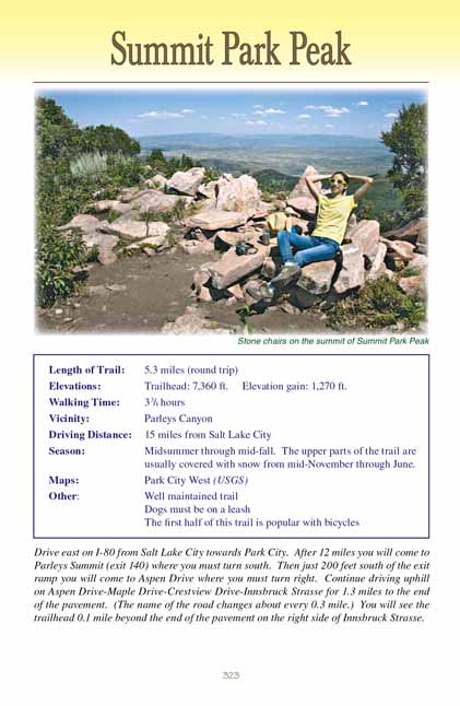
Canyon to the south. Interestingly, past hikers have taken the trouble to rearrange some of the flat rocks at the summit into four comfortable Flintstones-style
reclining chairs, so be sure to spend a while relaxing at the top and enjoy their handiwork.
The return route from Summit Park Peak continues to follow the Over Easy Trail west along the ridge for 0.7 mile before again joining the Road to WOS. Five minutes after
rejoining the Over Easy Trail you will pass an interesting bivouac on your right. Someone has laboriously constructed a tiny hut just off the trail under a group
of trees, and inside there is a chair and a cute table made of sticks.
0.2 mile beyond the bivouac you will come to a fork in the Over Easy Trail where you should bear right, and beyond that point the trail turns north and begins
dropping down the east side of the ridge to meet the Road to WOS. Turn north when you come to the Road to WOS and retrace your steps back over the Short Stack
Trail to the trailhead.
Note to web developers: You may copy this material onto your site, but in return please include a link to my home page
www.utahtrails.com. Thank you, David Day (utahdavidday at gmail.com)
Click here to see more
trails near Salt Lake City
© Rincon Publishing Company, all rights reserved
|