Mount Timpanogos
via Timpooneke Trail
excerpted from our book
Salt Lake City's Incredible Hiking and Biking Trails
pages 184-189
|
Buy book directly from the author!
Salt Lake City's Incredible Hiking and Biking Trails
- has access info for 73 trailheads
- 73 colorful trail maps
- 325 full color photographs
- loads of hiking tips
|
regularly $19.95
now on sale for only
$9.95
click here
for book orders
|
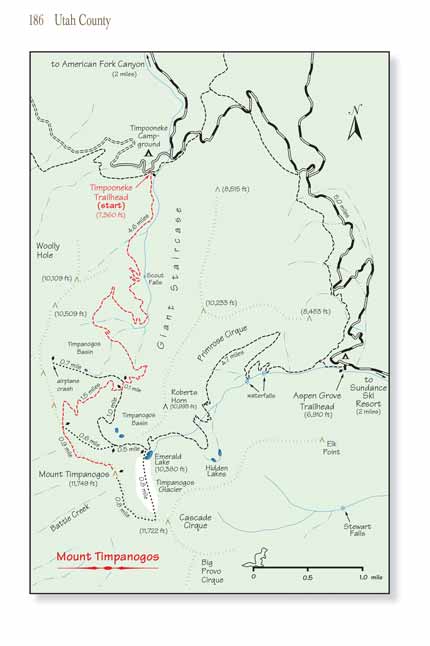
 The Forest Service maintains two popular trails to the summit of Mount Timpanogos: the older trail, discussed in the next chapter, begins at the Aspen
Grove Trailhead near the Sundance Ski Resort, and the newer trail, described below, begins at the Timpooneke Campground in American Fork Canyon. The
two Mount Timpanogos trails come together 0.9 mile north of the peak on the Timpanogos summit ridge. The lower sections of each trail are quite different, however, and
for that reason I have decided to describe each trail separately. Whichever one you choose, you will be amply rewarded for your efforts.
The Forest Service maintains two popular trails to the summit of Mount Timpanogos: the older trail, discussed in the next chapter, begins at the Aspen
Grove Trailhead near the Sundance Ski Resort, and the newer trail, described below, begins at the Timpooneke Campground in American Fork Canyon. The
two Mount Timpanogos trails come together 0.9 mile north of the peak on the Timpanogos summit ridge. The lower sections of each trail are quite different, however, and
for that reason I have decided to describe each trail separately. Whichever one you choose, you will be amply rewarded for your efforts.
The Timpooneke Trail is a half-mile longer than the Aspen Grove Trail, but if you begin at Aspen Grove you will have to deal with an additional 450 feet
of elevation gain. Consequently, the Timpooneke Trail is slightly less strenuous. Another thing to consider is snow cover. The snow on the Timpooneke side
seems to melt 2-3 weeks earlier than the snow on the Aspen Grove side of Mount
Timpanogos, so if you are planning to climb the mountain before late July the Timpooneke Trail is
a better choice.
The Timpooneke Trail has nothing to match Emerald Lake and the Timpanogos Glacier, which are major attractions of the traditional Aspen Grove Trail
. However, the hike up Mount Timpanogos on the Timpooneke Trail will give you the opportunity to visit the site of an interesting airplane crash that occurred on the ridge
above Timpanogos Basin in 1955. Also, in my opinion, the geology of the Giant Staircase, up which the Timpooneke Trail ascends, is more interesting than
the geology of Primrose Cirque on the Aspen Grove side.
If you have two cars you might consider going up
Mount Timpanogos on the Timpooneke Trail and ending the hike at Aspen Grove. Better yet, doing this hike
as an overnighter should be considered. Most people need at least 10 hours to do either of these trails as a day hike, and that doesn't leave much time to
enjoy either Emerald Lake or Timpanogos Basin. Probably the best of all options is to climb
the Mount Timpanogos summit as a two-day hike and spend the night either
at Emerald Lake or in Timpanogos Basin.
 The Timpooneke Trailhead also serves as an access point for the Great Western Trail; consequently there is sometimes confusion about which one of three
trails you should follow. Choose the middle one that proceeds in a southerly direction along the left side of the drainage. Initially the gentle trail
is a pleasant stroll through a forest of Douglas fir and Engelmann Spruce, but soon it begins climbing
Mount Timpanogos at a steeper grade as it veers away to the west
of the drainage. After 0.4 mile the trail briefly levels out again onto a small but relatively flat area on the floor of the canyon.
The Timpooneke Trailhead also serves as an access point for the Great Western Trail; consequently there is sometimes confusion about which one of three
trails you should follow. Choose the middle one that proceeds in a southerly direction along the left side of the drainage. Initially the gentle trail
is a pleasant stroll through a forest of Douglas fir and Engelmann Spruce, but soon it begins climbing
Mount Timpanogos at a steeper grade as it veers away to the west
of the drainage. After 0.4 mile the trail briefly levels out again onto a small but relatively flat area on the floor of the canyon.
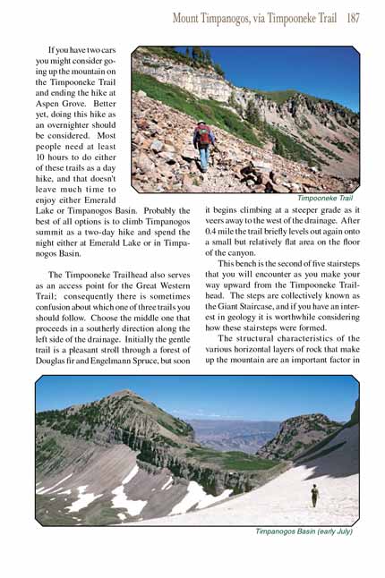
This bench is the second of five stairsteps that you will encounter as you make your way upward from the Timpooneke Trailhead. The steps are collectively
known as the Giant Staircase, and if you have an interest in geology it is worthwhile considering how these stairsteps were formed.
The structural characteristics of the various horizontal layers of rock that make up the mountain are an important factor in how the steps were formed.
The Mount Timpanogos massif is composed primarily of sedimentary limestone, shale and sandstone, with very different hardnesses. The bedrock below at least two
of the steps has been swept clean to reveal a layer of hard, unfractured limestone. Another factor is that the valley was not carved by a single glacier,
but by several glaciers of varying sizes and thicknesses. Over the past 2.5 million years the mountain has been subjected to the forces of glaciation on
at least four or five different occasions. It was periodic gouging and scraping of the many glaciers through the uneven layers of rock that produced the
Giant Staircase.
The next step in the Giant Staircase is at the top of Scout Falls, a seasonal waterfall you will see on the left side of the trail. When you reach
the step above Scout Falls the trail remains on the relatively flat bench for 0.5 mile before making a long turn to the west as it switchbacks its way
up and over another step on its climb toward Timpanogos Basin.
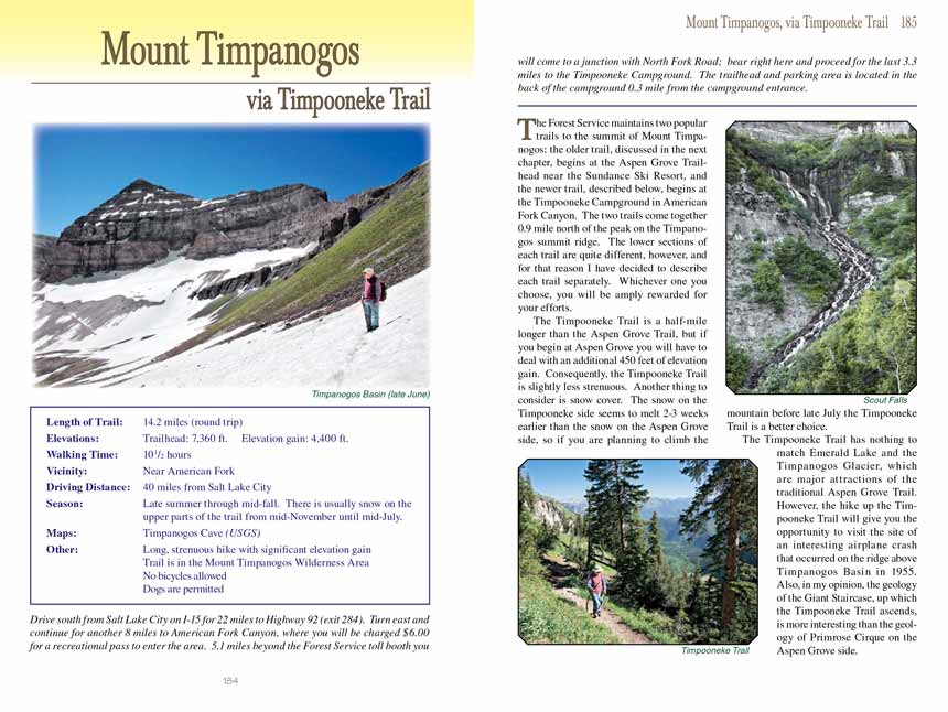
 Timpanogos Basin is a large relatively treeless depression on the northeast side of the
Mount Timpanogos summit ridge. Snow usually stays in the basin long into
the summer, and there are usually several small ponds of water along the sides of the basin. Soon after reaching the basin you will see a small sign that
says "toilet" near a spur trail on your right. After 200 yards this trail arrives at a fine camping site with a primitive Forest Service toilet nearby.
This is a great place to spend the night if you are planning to spend an extra day on the mountain.
Timpanogos Basin is a large relatively treeless depression on the northeast side of the
Mount Timpanogos summit ridge. Snow usually stays in the basin long into
the summer, and there are usually several small ponds of water along the sides of the basin. Soon after reaching the basin you will see a small sign that
says "toilet" near a spur trail on your right. After 200 yards this trail arrives at a fine camping site with a primitive Forest Service toilet nearby.
This is a great place to spend the night if you are planning to spend an extra day on the mountain.
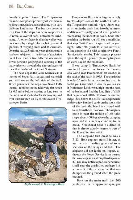
If you camp in Timpanogos Basin be sure to take some time to see the remains of a World War Two bomber that crashed in the back of the basin in 1955. The
crash site is only 0.5 mile from the camping area; in fact if you know what to look for you can see it from there. Look west, high into the back of the basin,
and find the long line of cliffs that begin about 200 feet below the Mount
Timpanogos summit ridge. Just below the cliffs is a steep bench, and for a few hundred yards on
the south side of the basin the bench is covered with talus from the cliffs above. The airplane crash is near the middle of this talus slope about 400 feet
above the camping area, and it is an easy climb up to the crash. You should head in a direction that is almost exactly magnetic west of the Forest Service
toilet.
The airplane that crashed was a B-25. Both engines are still intact, as are the main landing gear and some sections of the wings and tail. The airplane did not
ignite on impact, although the Forest Service later burned the wreckage in an attempt to dispose of it. You may notice a peculiar chemical smell near the crash
site; perhaps it is a remnant of the aviation fuel that was dumped on the ground when the plane crashed.
Back on the main trail to Mount Timpanogos, just 200 yards past the campground spur, you will come to another junction where the summit trail departs to the right. Emerald Lake is
1.5 miles ahead from this junction, but if your intent is to climb to the summit of Mount Timpanogos you must turn right here.
The summit trail immediately starts winding upward toward a saddle on the ridge north of the peak. The saddle is about 900 feet higher than the basin and well
above timberline, so be ready for some marvelous views. Provo, Orem, and Utah Lake are prominently displayed below the west side of the ridge, while Timpanogos
Peak holds a commanding position above the ridge 0.6 mile to the south.
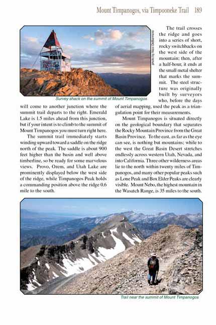
The trail crosses the ridge and goes into a series of short, rocky switchbacks on the west side of the mountain; then, after a half-hour, it ends at the
small metal shelter that marks the summit. The steel structure was originally built by surveyors who, before the days of aerial mapping, used the peak
as a triangulation point for their measurements.
Mount Timpanogos is situated directly on the geological boundary that separates the Rocky Mountain Province from the Great Basin Province. To the east,
as far as the eye can see, is nothing but mountains; while to the west the Great Basin Desert stretches endlessly across western Utah, Nevada, and into
California. Three other wilderness areas lie to the north within twenty miles of Timpanogos, and many other popular peaks such as Lone Peak and Box Elder
Peaks are clearly visible. Mount Nebo, the highest mountain in the Wasatch Range, is 35 miles to the south.
Note to web developers: You may copy this material onto your site, but in return please include a link to my home page
www.utahtrails.com. Thank you, David Day (utahdavidday
at gmail.com)
Click here to see more
trails near Salt Lake City
© Rincon Publishing Company, all rights reserved
|