White Pine Lake Trail
excerpted from our book
Salt Lake City's Incredible Hiking and Biking Trails
pages 111-113
|
Buy book directly from the author!
Salt Lake City's Incredible Hiking and Biking Trails
- has access info for 73 trailheads
- 73 colorful trail maps
- 325 full color photographs
- loads of hiking tips
|
regularly $19.95
now on sale for only
$9.95
click here
for book orders
|
Like Alexander Basin, ten miles to the north, the area around White Pine Lake has long been the subject of intense controversy
between Utahĺs environmentalists and ski resort owners. The original boundaries of Lone Peak Wilderness Area, created in 1977, were meant to include White Pine
Lake, but lobbyists representing the nearby Snowbird Ski Resort succeeded in having White Pine Canyon excluded. Snowbirdĺs Gad Valley ski lifts are only one
mile from White Pine Fork, yet in spite of the nearness of civilization the pristine alpine lake still has that wild feeling of remoteness. What a shame it
would be to open it up to commercial activity.
The trail to White Pine Lake actually follows an old jeep road that was built in the early 1900s to service small-claim mines in the canyon. The mining activity
proved uneconomical, however, and it has been many years since the road was used. Now the Forest Service no longer allows motor vehicles in the area, and the
vegetation has been so successful in reclaiming the track that few hikers will recognize that they are following an old road. Because the trail was originally
a road it is not as steep as it would otherwise be. But, by the same token, the winding route is much longer than necessary.
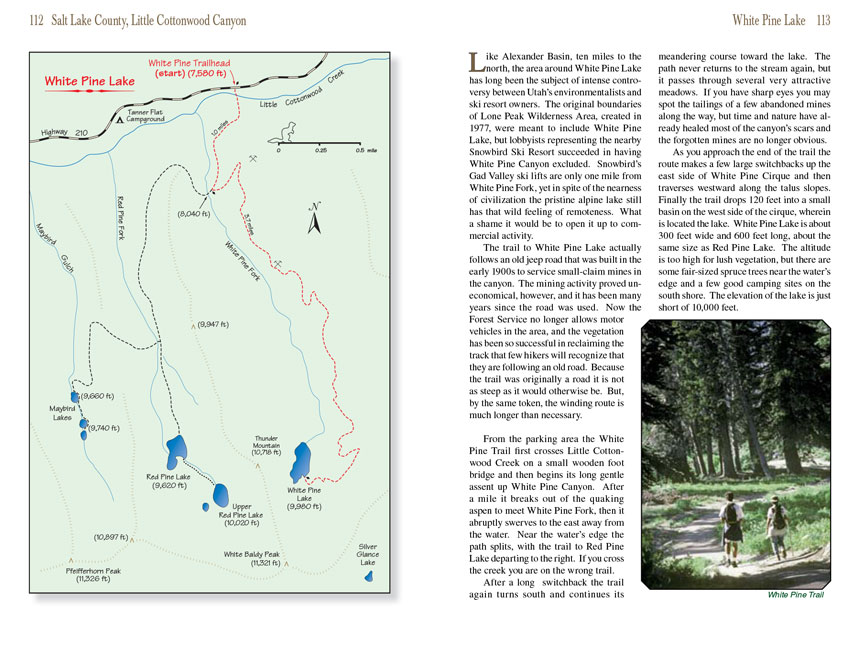
From the parking area the White Pine Trail first crosses Little Cottonwood Creek on a small wooden foot bridge and then begins its long gentle assent up White Pine
Canyon. After a mile it breaks out of the quaking aspen to meet White Pine Fork, then it abruptly swerves to the east away from the water. Near the waterĺs edge
the path splits, with the trail to Red Pine Lake departing to the right. If you cross the creek you are on the wrong trail.
After a long switchback the White Pine Lake trail again turns south and continues its meandering course toward the lake. The path never returns to the stream again, but it
passes through several very attractive meadows. If you have sharp eyes you may spot the tailings of a few abandoned mines along the way, but time and nature
have already healed most of the canyonĺs scars and the forgotten mines are no longer obvious.
As you approach the end of the trail the route makes a few large switchbacks up the east side of White Pine Cirque and then traverses westward along the talus
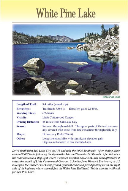
slopes. Finally the trail drops 120 feet into a small basin on the west side of the cirque, wherein is located the lake. White Pine Lake is about 300 feet
wide and 600 feet long, about the same size as Red Pine Lake. The altitude is too high for lush vegetation, but there are some fair-sized spruce trees near
the waterĺs edge and a few good camping sites on the south shore. The elevation of
White Pine Lake is just short of 10,000 feet.
Note to web developers: You may copy this material onto your site, but in return please include a link to my home page
www.utahtrails.com. Thank you, David Day (utahdavidday at gmail.com)
Click here to see more
trails near Salt Lake City
ę Rincon Publishing Company, all rights reserved
|