|
The White Crack Trail was named after a natural fissure in the White Rim Formation that was once used by cowboys and mining prospectors seeking access to the lower benches of Canyonlands. The first recorded use of the crack was by a group of cattle ranchers who developed it into a trail around 1918 so they could use the lower plateaus for grazing. Then in the early 1950s the crack was widened by uranium miners while they were constructing a jeep road to a point near the Green River. Today the jeep trail no longer appears on Park Service maps, and it has so deteriorated that it would now be impossible to drive a jeep over it. Nevertheless, the old road makes an interesting hiking trail. It ends at an abandoned mining camp on the edge of a plateau 760 feet above the river.
The hike to the mining camp and back can be done in one day, but there are several interesting side trips in the area if you wish to spend a night above the river. Unfortunately there is no easily accessible water nearby. If you are lucky enough to be doing this hike right after a storm you can find water in numerous sandstone potholes along the trail, but these potholes usually dry up within a few days. The only other alternative is to get water from the Green River. The river is a 45 minute scramble from the mining camp down Stove Canyon, but then you have a 760-foot climb back to the camp-a lot of work for a drink of muddy water!
The most interesting side trip from the mining camp is the cross-country hike to the confluence of the Green and Colorado rivers. Few people make this relatively easy hike, and largely for that reason it is a memorable one. Aside from the stunning view above the rivers, the walk across the flat, open desert on the plateau above the rivers is an interesting experience. Your field of view is uninterrupted for miles in every direction, there is no trail of any kind to guide you, and the landscape is complete unmarred by any sign of humanity. I did this hike alone in the early hours of a spring morning, and I found it to be almost a religious experience. At first the emptiness and the silence of the morning seemed almost overwhelming. But then I began to notice things that at first I hadn’t seen. A lone bird chirping to attract others of its kind. A ground squirrel standing motionless, hoping I wouldn’t see it. A brilliant red cactus flower challenging the more subdued colors of the sand and shale. Nature is rarely silent, but here in the desert she rarely speaks above a whisper. And we must listen carefully with all of our senses if we expect to hear her message.
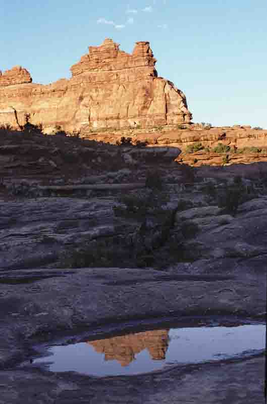
The trail starts on the southern side of the White Crack Camp parking area. There are no signs marking the trailhead, but if you look carefully you will see the remnants of an old jeep road departing to the south towards the canyon rim. After walking 150 yards along this road you will come to the edge of the White Rim Formation where, on your left, you can see the White Crack. Before the 1950s the White Crack was just a cleft in the White Rim Sandstone, but now it is a 12-foot-wide roadbed that has been blasted out with dynamite.
From the rim you can clearly see the first mile of trail winding across the plateau below. After its descent through the crack it heads west for another 0.4 mile to the base of a large stone pinnacle. It then turns and switchbacks down the rest of the way to the top of the bench 400 feet below the White Rim. After this initial descent the trail stays at an almost constant elevation for the next 5.8 miles to the abandoned mining camp. It winds along the benches, first in a westerly direction, then south, and finally east, always twisting and turning to get around side canyons and other obstacles. For a long while the route never strays far from the 4800-foot contour line, then in the last two miles it slowly descends the last 150 feet to the mining camp
The first good views of the Green River will come about a mile before you reach the mining camp. At one point, 5.4 miles from the trailhead, the path crosses the end of a long, narrow finger of land that juts out for 0.3 mile above the east side of the river. If you take the time to drop your pack and walk out on the promontory you will rewarded with a superb view of the river and its canyons.
The trail finally reaches Stove Canyon on its east side, and then follows a narrow shelf of sandstone for another 200 yards to the remains of the old mining camp. The cabin that was once here burned down about 15 years ago, but two iron beds still stand incongruously on the slickrock facing the river below. With a spring bed to sleep on and a view like that at your front door, maybe life for those old prospectors wasn’t so bad after all. It’s too bad the old beds are no longer usable. What a place to stretch out on a clear night and gaze up at the stars!
If the mining camp is your final destination this round-trip hike can easily be completed on one day. However, if time and especially water are not a problem there are a couple of interesting ways to spend another day in this area.
Stove Canyon
Before the White Crack Road was built the uranium prospectors accessed this area by way of the Green River. There is some evidence that they had a crude tram for hauling supplies and equipment up from the bottom of Stove Canyon, and a nearby pile of iron pipes indicates that they probably intended to build a water line down to the river. There is a crude hiker-made trail through Stove Canyon to the Green River, and an interesting side trip is to retrace the miners’ steps down to the water. It will take you about 45 minutes to reach the river and, depending on what kind of shape you are in, an hour and a half to get back up. There is just enough scrambling to make the hike interesting
The beginning of the trail can be seen near the top of the canyon on the opposite side from the mining camp. The trail works its way down several narrow benches along the west side of the ravine before finally reaching the streambed 150 feet below the camp. It then heads straight down the drainage, loosing another 200 feet of elevation, until the canyon opens up above the river. For the last 400 feet the trail descends down an old slide area above the river. There are some great campsites near the Green River if you want to haul your pack down Stove Canyon.
Green and Colorado River Confluence
The hike from the mining camp to the confluence is 2.2 miles each way, and will take you about 2˝ hours to complete. The route is very easy walking with little elevation gain, but there are no trail markers of any kind to follow. You should have a compass for this walk.
From the mining camp the road continues for a short distance beyond the end of Stove Canyon and then soon disappears on the sandy plateau above. The miners once had an airstrip here. From the lay of the land it must have been oriented in an east-west direction, but I was not able to pinpoint its exact location. Fifty years of wind and rain have pretty much erased its mark from the land.
Before starting out across the plateau you should make a mental note of what the area above the mining camp looks like so you will know how to get back. The confluence is almost due magnetic south of the mining camp, but it is better if you start initially in a southeasterly direction. Otherwise your route will take you too close to the top of the Green River gorge, where the land is not as flat. Start out on a compass heading of about 145 degrees, or 35 degrees east of south, and after you have walked about 15 minutes you can start turning south. By now you will see the top of the Green River gorge on your right. Keep walking south until you see the Colorado River gorge on your left and then turn a little to the west, staying approximately in the center of the two gorges.
As you approach the confluence there will be many little side drainages veering off both on the right and the left. Be careful not to drop into any of these arroyos-just stay on the slickrock at the top of the watershed. Near the end there will be two prominent outcroppings of sandstone on either side of the route. Go between them, staying closer to the outcropping on the left, and soon you will arrive at the northern rim of the Colorado River gorge just a short distance upstream from the confluence. The dramatic view of the two mighty rivers coming together is awesome, and there is no better place in the national park to see it.
When returning to the mining camp you can use Junction Butte as a landmark to keep you headed in the right direction. The prominent landmark rises almost due magnetic north of the confluence, about four miles north of the mining camp. But, again, you will have to veer initially to the east on the way back to get around the uneven terrain near the Green River gorge.
There is another item of interest above the mining camp that you might want to check out on your way back from the confluence. Pay attention to the low cliffs on your right as you approach the old airstrip, and you should see a large alcove two hundred yards off the trail with two small holes in its roof. This alcove makes an interesting stop. There is also evidence that the area around the alcove was once inhabited by the Anasazis. I wasn’t able to find any ruins, but there are hundreds of flint flakes scattered across the wash in front of the alcove. These flakes do not occur naturally; they were the tools of a stone-age culture. The flakes were chipped from larger chunks of chert, a hard igneous rock that was mined by prehistoric people throughout Canyonlands.
|