|
Links to other sites:
Do you have any recent information to add about this road?
Ordering books & Maps
Free sample copies of Outdoor Magazines
Comments about this site or our book:

|
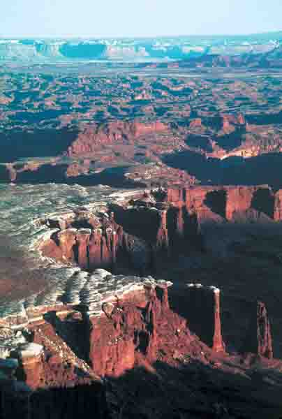
Trying to decide which is the best viewpoint in
Canyonlands National Park is an impossible task, but the White Rim Overlook
definitely ranks among the top two or three. The overlook point lies on the
eastern end of a long, slender finger of land that extends outward for
nearly a mile from the southern end of the Island in the Sky. From the end
of the promontory it seems as if the whole world is below you. If you like
sunrise vistas the White Rim Overlook presents a great vantage point for
watching the morning’s first rays of light make their way into the deep
recesses of the vast desert below the rim.
The trail begins at the picnic area beside the road and
immediately heads out with no change in elevation in an easterly direction.
About half way along you will begin to notice the plateau becoming
increasingly narrower, and ultimately the trail ends simply because there is
no more room on the point for it. The canyon on the north side of the point
is Gooseberry Canyon, and the White Rim Road can be seen for miles as it
makes its way from Gooseberry around the east side of the viewpoint to
Monument Basin in the south. The road follows the flat tableland of the
White Rim Plateau, a thousand feet below the White Rim Overlook.
|