|
Before
driving this road you should be sure to spend some time at the overlook
points on the Island in the Sky Mesa south of the visitor center. The thread
of the White Rim Road can clearly be seen from all of these vantage points,
as it winds its way across the White Rim Plateau 1,200 feet below the mesa.
The views are extremely impressive, and few observers will not feel a pang
of excitement at the prospect of following the road through the canyon
below. The views are particularly striking from the Grandview and White Rim
Overlooks at the south end of the Grandview Point, where the White Rim Road
skirts around Monument Basin and Gooseberry Canyon above the western side of
the Colorado River.
The White Rim
Road and the White Rim Plateau were both named after a thin but very hard
layer of White Rim Sandstone that was deposited some 225 million years ago
at the top of a geologic layer called the Cutler Formation. Millions of
years later new layers of shale, mudstone, and sandstone were deposited over
the White Rim Sandstone; then, after the Green and Colorado Rivers were
formed, these softer overlying layers began to erode away. This action
resulted in the formation of a wide, flat bench of desert, the White Rim
Plateau, that now lies between the river gorges below and the mesa tops
above.
In the early
1950s uranium was discovered in the shales overlying the White Rim
Sandstone, and the flat bench became a natural access route for building
roads to the mining claims. Thus the White Rim Road was born. The uranium
boom lasted for only 3-4 years, however, and the primitive road was never
improved. After the mid-1950s new discoveries in more accessible places
caused the price of the yellow ore to plunge, and by the end of the decade
the mines in Canyonlands were abandoned.
When
Canyonlands National Park was formed in 1964 there was some talk of
improving the White Rim Road into a scenic loop drive, but fortunately that
never happened. Today, thanks to the short-lived uranium boom and the wise
foresight of early park mangers, the White Rim Road has become one of the
premier recreational jeep and mountain biking roads in the United States.
The Park Service has built nineteen primitive campsites along its 70-mile
length (for which reservations are required), but no further development is
contemplated.
Airport Camp (17.3 miles)
From Highway 313 the road proceeds south for 0.8
mile to the edge of Shafer Canyon. It then turns west onto a narrow bench
just below the Navajo Sandstone, which it follows for the next 1.9 miles
before beginning a series of dramatic switchbacks that lead down into the
bottom of the gorge. This section of road, known as the Shafer Trail, was
first developed as a horse trail around 1917 by a cattle rancher named Sog
Shafer. Then in 1952 a group of local miners and other businessmen improved
the road so it could be used to haul uranium ore from mines near Potash and
the Colorado River to the top of the mesa.
After five
large switchbacks the Shafer Trail straightens out and continues its descent
down through the bottom of Shafer Canyon, finally arriving at the junction
with the Potash Road 5.2 miles from the Highway. This junction marks the
beginning of the White Rim Road, and you should bear to the right here.
Continue east towards the Colorado River for another 1.3 miles until you see
a small sign on the left marking the Gooseneck Trailhead.
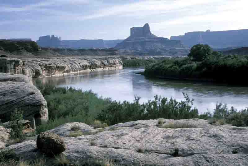
The Gooseneck
Trail offers the first opportunity along this road to get a good look at the
Colorado River. It also serves as an introduction to the White Rim
Sandstone, which first becomes visible in this area. The panorama of the
Colorado River below the trail is very picturesque, but if you want to take
pictures you should have a wide-angle lens. (See page 89 for a complete
description of this trail.)
The road
continues along the top of the White Rim Formation as it proceeds south from
the Gooseneck Trailhead. Initially the sandstone layer is less than ten feet
thick, but it gradually becomes much thicker. After another 1.8 miles you
will come to another sign that says "Colorado River Overlook", and
from there a short spur road leads to another overlook point just 300 yards
from the main road. This view of the river is not as spectacular as the one
from the end of the Gooseneck Trail, but no hiking is required to reach the
Colorado River Overlook.
Although the
Colorado River Overlook is not particularly impressive, there is an
extremely interesting area a short distance east of the overlook point
called the Walking Rocks. Walk along the rim from the car park for about 0.2
mile and you will begin to see a number of long narrow cracks near the edge
of the White Rim Sandstone. These cracks occur where large blocks of the
20-foot-thick layer of sandstone have broken away from the main formation
but are still supported by the underlying Organ Shale and have not yet
fallen into the canyon below. Many of the cracks are only 6-18 inches wide;
consequently it is possible to jump from one balanced rock to the next, like
following a series of giant mushroom-shaped stepping stones that lead to
nowhere. Crossing the narrow gaps between the blocks is not particularly
dangerous, but gazing down at a hundred feet of empty space under your feet
as you hop from rock to rock is very unnerving. It is not a good place for
careless people, and I would definitely not recommend it for children. It is
also not a place you would want to be during an earthquake. Indiana Jones
would love the Walking Rocks
The next
point of interest, the Musselman Arch, is only 0.2 mile beyond the Colorado
River Overlook. The arch is located 150 yards from the main road at the end
of another turnout on the left. Again, the arch was formed when a piece of
the White Rim cracked away from the plateau, but this time the shale washed
away from underneath its center forming a natural arch about 80 feet long.
There is no easy way to get below the White Rim at Musselman Arch, but if
you want to climb under the arch you can get there from the Walking Rocks.
From there it is possible to climb to the bottom of the White Rim Formation
and scramble back 0.5 mile to a point below Musselman Arch.
The old
timers in Moab tell an interesting story about how Musselman Arch got its
name. Sometime in the early 1940s a man named Ross Musselman heard about the
arch and persuaded a friend in Moab to show him where it was. He owned a
dude ranch in the area and was looking for interesting places to take his
guests. Word of the arch spread quickly after Musselman began showing it,
and before long outsiders visiting the area started calling it the Musselman
Arch. Needless to say this greatly irritated the local cowboys and ranchers
who had known about the arch for decades before it was
"discovered" by Ross Musselman. They grumbled for years about his
ill-deserved fame. Now, as if to rub salt into the old timers’ wounds, the
USGS has also given Musselman’s name to a nearby canyon and even to the
7.5 minute topographical map covering this section of Canyonlands.
For the next
7.5 miles after leaving Musselman Arch the White Rim Road continues
southward over the flat sandy plateau, passing near the rim of Musselman
Canyon, Little Bridge Canyon, and finally Lathrop Canyon. The Colorado River
is no longer visible; nevertheless there are a number of impressive vistas
along the way. On your right are the rouge-colored cliffs of the Wingate
Formation plunging down from the top of the Island in the Sky, and on your
left are the rugged canyons below the White Rim, deeply cut into the dark
red shale of the Cutler Formation. The White Rim Road is usually good enough
for almost any car to travel as far as Musselman Arch, but ordinary cars
will run into trouble a few miles beyond the arch. Pickup trucks and other
high-center vehicles can usually make it another 34 miles to the bottom of
the Murphy Hogback.
Shortly after
passing Lathrop Canyon you will come to a sign marking the Lathrop Trail, a
5-mile-long path leading from the White Rim Road to the top of the Island in
the Sky. This trail was built sometime in the mid-1940s by a sheep rancher
named Howard Lathrop who used the White Rim Plateau as a winter grazing
range for his sheep. The trail was also used in the early 1950s by uranium
miners who had claims just below the base of the Wingate cliffs. (See page
44 for a description of the Lathrop Trail.)
200 yards
beyond the Lathrop Trail you will come to the Lathrop Canyon Road, a
3.7-mile side road that drops down from the top of the White Rim, through
Lathrop Canyon, to the Colorado River. This road was built by the early
uranium miners at about the same time the White Rim Road was built, but it
is likely that Howard Lathrop also had a trail here ten years earlier for
his sheep. Lathrop Canyon is the only place in Canyonlands National Park
where the Colorado River can be accessed by car. The road is very rough and
sandy, but it can be driven with a 4WD vehicle without too much difficulty.
The Park Service has even established a picnic area at the bottom of the
canyon and bulldozed a ramp to the river for pulling boats out of the water.
This crude ramp represents the last chance for river runners to get their
boats out of the Colorado before reaching the notorious rapids of Cataract
Canyon 27 miles further down-river (unless they choose to motor back up the
Colorado or the Green River).
As you leave
Lathrop Canyon on the White Rim Road you will see the Airport Tower Butte on
the right side, and after 0.9 mile you will arrive at Airport Tower
Campsites A and B, the first of the nineteen campsites along the White Rim
Road. Sites C and D are 0.4 miles further.
Gooseberry Camp (10.6 miles)
Soon after leaving the
Airport Tower Campsites C and D, another distinctive pinnacle of sandstone
called the Monster Tower will come into view on the right side of the road.
You can also see the Washerwoman Arch high on the sandstone cliffs of a
smaller pinnacle on the north side of the Monster Tower. Look carefully at
the smaller tower, and if you have a good imagination you should be able to
identify the giant stone woman washing her clothes.
About a
half-mile east of these landmarks the road crosses Buck Canyon, a heavily
eroded canyon that was used by sheep rancher Howard Lathrop in the 1940s.
Lathrop used the canyon to pen up his rams after the spring breeding season
while the ewes were nursing their newborn lambs. Off-trail hikers might want
to take note: It is a relatively easy walk of 5.2 miles from the road down
Buck Canyon to the Colorado River. There are also several seasonal springs
in the canyon.
From Buck
Canyon the road continues to work its way southward along the base of
Grandview Point, meandering around the heads of the Middle and South Forks
of Buck Canyon, and then Gooseberry Canyon 8.5 miles later. The road passes
very close to the rims of these canyons, but nowhere as close as at head of
South Fork Buck Canyon. Be careful here, because at one point your left
tires will be only three feet away from a 200-foot drop. Furthermore the
White Rim is undercut by about 40 feet, leaving nothing but air under the
road!
3.1 miles
beyond South Fork Buck Canyon the road crosses the wash above Gooseberry
Canyon, where you will see another sign marking the Gooseberry Trailhead.
The Gooseberry Trail was built in the late 1930s by WPA workers, and many
old timers in the area still call it the Government Trail. Like several
other trails in the area, it was built to enable local sheep and cattle
ranchers to take their livestock from the Island in the Sky Mesa to the
White Rim Plateau for winter grazing. (See page 56 for a description of this
trail.) Gooseberry Campsites A and B are located 0.3 and 0.4 miles past the
trailhead.
White Crack Camp (9.5 miles)
4.1 miles after leaving
Gooseberry Campsite B you will come to one of the most impressive sights on
the White Rim Road: Monument Basin. This area is well known because so many
people have seen it from above. It lies just below the heavily visited
Grandview Overlook on the southern end of the Island in the Sky, and every
day hundreds of tourists peer down at Monument Basin’s fascinating
collection of geologic sculpture 1,900 feet below the mesa top. The basin
consists of a large rocky desert valley about a mile across and 500 feet
below the White Rim Plateau that is filled with dozens of pillars of Organ
Shale capped with blocks of White Rim Sandstone. The road first approaches
the basin on its northeast side and then follows its perimeter for the next
three miles, giving onlookers the opportunity to view the spectacle from
many different angles. The vista is particularly impressive in the late
afternoon when the shale turns a deep red color and the pinnacles cast long
shadows across the canyon floor.
As you leave
the last viewpoint on the west side of Monument Basin the road swings to the
west and arrives shortly at a sign marking the spur to White Crack Camp.
This campsite is located 1.3 miles from the main road at the extreme
southern end of the White Rim Plateau. White Crack Camp, with its great
views from the edge of the White Rim, is one of my favorites. Since it is
located some distance from the main road it is quieter and more private, and
there is room for only one group of campers.
The White
Crack Camp was named after a crack in the White Rim Sandstone just south of
the car parking area. This break in the White Rim was developed into a trail
around 1918 so ranchers could get their animals to water in the lower
canyons. Then in the early 1950s the trail was widened into a jeep road and
extended to a mining camp above the Green River. Today the jeep road is no
longer suitable for wheeled vehicles, but it is possible to hike along it to
the old mining camp. The distance is 6.2 miles each way. There are no longer
any standing buildings at the mining camp, but there are a few artifacts
lying about and the trail also offers some great views of the Green River.
The White Crack Trail is discussed in greater detail on page 92.
Murphy Camp (8.8 miles)
White Crack Camp lies at
the extreme southern end of the Island in the Sky district. Upon leaving
this area the road first goes west for about two miles in order to get
around Junction Butte, and then makes a sharp right turn as it begins the
long journey up the west side of Grandview Point. Soon it enters a region
known as Murphy Basin, named after a family that ran cattle here just after
World War One. There are several nice views along this section of road. If
you look west across the Green River Gorge you can see many famous landmarks
in the Maze District of Canyonlands off in the distance. The high
needle-like formation seven miles to the southwest is Chimney Rock, and the
flat-top mesa four miles west on the other side of the river is Ekker Butte.
Finally, 6.3
miles from White Crack Road, the White Rim Road crosses Murphy Wash, where a
small sign marks the beginning of the Murphy Wash Trail. This is another
livestock trail built by the Murphy brothers around 1917. The 3.7-mile-long
trail ends near Murphy Point at the top of the Island in the Sky. (See page
52 for more details about this hike.)
Shortly after
leaving Murphy Wash, the road gets much steeper as it claws its way out of
Murphy Basin up the southern side of the Murphy Hogback. You better shift
into low gear before beginning this climb, and you had better have a 4WD
vehicle. The elevation gain of the brief climb is only 250 feet, but it is
very steep near the top.
The view from
the top of the Hogback is a memorable panorama of the vast, heavily eroded
canyons below. The scenery is especially interesting north of the narrow
ridge where one can look down over the picturesque Soda Springs Basin.
Murphy Campsite C is located just a few feet from the northern side of the
Hogback, and the views into the basin below make it one of the most popular
camps on the White Rim Road. Sites A and B are situated nearby, but closer
to the middle of the crest.
There is also
another trailhead at the top of the ridge near campsite C. A small sign
marks the point where the Murphy Hogback Trail leaves the road for the top
of the Island in the Sky. This trail joins the Murphy Wash Trail 2.8 miles
from the White Rim Road, and an interesting loop hike is to walk as far as
the junction and return to the road on the Murphy Wash Trail. The total
distance of this loop, including the section of road between the two
trailheads is 6.8 miles. (See page 52 for more details.)
Candlestick Camp (10.4 miles)
From Murphy Hogback the
White Rim Road drops back down 600 feet to the White Rim Plateau and begins
skirting around the northeastern side of Soda Springs Basin. After
approaching the rim of the basin at several points the road departs from the
west side of Soda Springs and heads across the desert just north of a big
180-degree loop in the Green River. You should stop the car at this point
and walk to the edge of the rim 150 yards from the road for a terrific view
of the water below. The river’s gooseneck spreads across your field of
view like the screen in an I-Max movie theater-even with a 24-mm lens I wasn’t
able to frame the entire loop in my camera. Below your vantage point the
channel bends around an arc nearly a mile wide, and at the center of the
half-circle lies a picturesque butte called the Turks Head. Although you can’t
see the river unless you get out of your car and walk to the edge of the
rim, the huge flat top of the Turks Head is clearly visible from the road,
so when you see it be sure to stop.
The bottom
land below the Turks Head once supported a thriving community of Anasazi
Indians, and the remnants of their occupancy are scattered throughout the
area. If you study the cliffs above the lower terrace on the northeast side
of the butte with a pair of binoculars you should be able to see at least
three well preserved cliff dwellings where the ancient Indians lived and
stored their corn. The area was extensively cultivated, and the presence of
thousands of flint chips scattered about the ground shows that the Indians
who lived here were also actively engaged in the production of spearheads or
other stone tools.
From its
confluence with the Colorado River to the Turks Head the Green River flows
through Stillwater Canyon, a deep gorge in the Lower Cutler and Honaker
Trail Formations that makes in almost inaccessible from the upper plateaus.
But as you proceed north of the Turks Head you will notice a distinct
difference in the river’s personality. The canyon widens considerably,
forming many flat areas, or bottoms along the water’s edge, and the White
Rim Formation dips down very close to the river, making it more accessible
from above. Many of the river bottoms are very fertile areas for growing
crops, and they have long been sites for human habitation. The Fremont and
Anasazi Indians occupied this area for hundreds of years before their
disappearance around 1300 A.D., and today many remnants of their presence
can still be seen along the Green River north of Stillwater Canyon.
White men
arrived in this area in the late 1800s, and they too were attracted to these
river bottoms. Most of the white settlers raised cattle or sheep for a
living or supported themselves by hauling supplies to the other settlers
along the river. Some stayed on the bottomlands for only part of the year,
and others brought their families with them and attempted to establish
permanent homesteads. It has been about fifty years since anyone lived along
the river, but the ruins of several of the old settlers’ cabins are still
visible.
From the
Turks Head the road continues northwest, climbing over a low hill of shale,
before arriving at Candlestick Camp 2.6 miles later. Note the pinnacle of
Wingate Sandstone that rises abruptly from the desert floor two miles east
of the camp; this is Candlestick Tower, the formation for which Candlestick
Camp was named. Although you can’t see the river from the campsite,
Candlestick Camp is quite close to the edge of the White Rim. If you will
drive 0.2 mile north of the camp, park your car, and walk to the rim you can
see Valentine Bottom, a flat, green fertile piece of land on the south side
of the channel. This was one of the first places in Canyonlands to be
inhabited by white people. In 1892 the Valentines, a family of five adults
and two children, attempted to settle the bottom, but they stayed for only
one year. In 1893 they abandoned their homestead and moved upstream to the
town of Green River.
Potato Bottom Camp (10.2 miles)
Beyond Candlestick
Camp the road veers north of the river in order to get around a small side
canyon. At the head of the canyon, 2.2 miles from Candlestick Camp you will
see a sign marking the Wilhite Trail, a five-mile-long trail leading to the
top of the Island in the Sky. (See page 64.) The Wilhite Trail was built by
local sheep ranchers in the late 1930s to facilitate moving sheep and
supplies to their winter pasture below the top of the mesa.
As you cross
the sandy wash below the Wilhite Trailhead you will notice the slender
opening of a gracefully sculpted sandstone narrows on the left side of the
road where water occasionally rushes down a small side canyon on its way to
the Green River. Numerous footprints in the bottom of the wash attest to the
fact that many passers-by have yielded to an urge to stop and see what
unexpected surprises might lie beyond the smooth, sensuous portal. Perhaps
it is the curving femininity of the shape that draws them-the smooth,
suggestive flow of the creamy white stone. The narrow channel continues
deeper and deeper down into the White Rim Sandstone for a distance of about
300 yards before finally ending at a pouroff 50 feet above the canyon floor.
After the
Wilhite Trailhead the road heads southwest towards the Bonita Bend, a sharp
bend in the river named by John Wesley Powell during his famous exploration
of the Green River in 1869. If you stop your car at the point where the
river first comes into view and the road makes a sharp turn to the north,
3.5 miles beyond the Wilhite Trailhead, and walk 200 yards to the edge of
the rim you can look down river at the Bonita Bend with Anderson Bottom on
its western shore.
Anderson
Bottom figures prominently in the history of the Green River. It was named
after Albert Isaac Anderson who attempted to establish a homestead there in
1909 but stayed for only three years. Anderson was followed by a succession
of at least five more families who inhabited the bottom for varying lengths
of time from 1912 until it became part of the national park in 1964.
The first
place where the Green River is easily accessible is Queen Anne Bottom, 1.5
miles upstream from Anderson Bottom. During the uranium boom in the 1950s a
tram was built across the river on the northern end of the bottom. The tram
is gone now, but some evidence of it can still be seen on the west side of
the river. The bottom was named after a colorful lady named Anne who lived
there alone for a few years around 1918. At one point she acquired a large
flat-bottom boat and tried to start a business ferrying supplies to other
settlers along the river. The business didn’t do well, however, and before
1920 Anne had vacated her home and moved elsewhere. Watch for an old jeep
road that leads from the White Rim Road to the river at Queen Anne Bottom.
The Park Service has blocked the road off and it is now illegal to drive on
it, but it is only a ten-minute walk down this road to the river.
Unfortunately there isn’t much to see at Queen Anne Bottom now except a
jungle of tamarisk trees.
3.3 miles
north of Queen Anne Bottom you will arrive at Potato Bottom Campsite A and,
after another 0.7 mile, campsites B and C. All three sites are pleasantly
located in the cottonwood trees on a bench just above the river. Notice that
the White Rim Sandstone disappears beneath the surface at this point. The
remainder of the White Rim Road will be over the shale of the Moenkopi and
Chinle Formations.
There is no
evidence that Potato Bottom was ever homesteaded, but it was often used
during the first half of the last century as a cowboy camp. One of the camps
is located 0.3 miles south of Potato Bottom Campsite A, near where the White
Rim Sandstone disappears underground. Drive back from the campsite to the
last place where you can easily park off the road, then walk south along the
bottom of the White Rim for another hundred yards to a small alcove behind
the tamarisk. The small, nondescript alcove isn’t much to look at now, but
it was used for many decades by cowboys as a place to get out of the wind
and rain. Sometime around 1930 a cowpoke named Art Murry placed a trunk in
the alcove to store his groceries and belongings and, interestingly, the
remains of the trunk are still there today.
Hardscrabble Camp B (4.3 miles)
Just beyond the last
campsite in Potato Bottom the road encounters an obstacle that it must get
around. This is where Bighorn Mesa, a long point of land on the west side of
the Island in the Sky, ends, and the steep sloping sides of the mesa make it
impossible for the White Rim Road to stay at the same elevation as the
river. The road climbs 400 feet to get to the top of the ridge and then
drops back down to the river on the other side. The section of road on the
south side of the crest, known as the Walker Cut, is very steep and rocky,
and as you start up you will be thankful you have a 4WD vehicle. The route
follows an old cow trail that was built by a rancher named Mark Walker
around 1890 and later widened to a jeep trail.
When you
reach the top of the Walker Cut you will come to sign marking the Fort
Bottom Trailhead. This 6.0-mile (round trip) trail is one of the more
interesting trails in Canyonlands, and if you have the time you should
definitely check it out. Looking west from the trailhead you will see a
large bend in the river where the waterway turns almost full circle to get
around the end of Bighorn Mesa. The ridge from the mesa ultimately ends at a
small butte in the center of the gooseneck, and if you look carefully at the
top of this butte you will soon see how Fort Bottom got its name. At the top
of the butte there is a cylindrical stone tower that was built long ago by
the Anasazi Indians. Its function is not known today, but it is easy to
imagine the butte as a fort, with the stone tower serving as a lookout post
over the houses and fields below. Turn to page 86 for more information on
the trail to Fort Bottom and the Anasazi ruin.
As you start
down the north side of the ridge you will see Hardscrabble Campsite B near
the river directly below the road. Hardscrabble is, in my opinion, the most
scenic and pleasant camp along the entire White Rim Road. It is well
sheltered, not sandy, and has good river access. The short spur road to
Hardscrabble Campsites A and B is at the bottom of the hill, 1.6 miles from
the Fort Bottom Trailhead.
Labyrinth and Taylor Camps (7.1 miles)
From the spur to
Hardscrabble Camp the road continues north at almost the same level as the
river. After 1.4 miles you will come to an area where Taylor Canyon and
Upheaval Canyon converge to form a large flat area on the east side of the
river called Upheaval Bottom. As you cross the sandy wash in the center of
the bottom you will see a small parking area next to a sign on the right
marking the Upheaval Canyon Trail. This trail follows Upheaval Canyon to the
bottom of Upheaval Crater. You can also get to the top of Island in the Sky
on this trail by taking the Syncline Loop Trail from Upheaval Crater to the
top of the mesa. (For more details on these trails turn to pages 72 and 82.)
There is also
an old settler’s cabin near the river on Upheaval Bottom that is worth
seeing; it is located about 350 yards from the Upheaval Canyon Trailhead. To
get there follow the wash towards the river for about 200 feet until you see
a hiker-made trail that climbs up the left side of the wash. Climb out of
the wash at this point and continue following the trail west for another 250
yards. First you will see the remains of an old corral under a small grove
of cottonwood trees. Then, after another 150 feet you should see the cabin
hidden in the tamarisk trees. This cabin was built by a Art Murry in the
early 1930s as a line cabin for cowboys working in the area. Though filled
with a deep layer of sand now, the cabin is still in fair shape. It even has
the remains of an old stove inside that, according to one old timer, the
cowboys used to cook sourdough bread.
The Park
Service used to maintain a campsite in Upheaval Bottom, but the site was
closed in the early 1990s and a new one, the Labyrinth Camp, was established
further upstream. Drive north along the river for another 0.7 mile to reach
the Labyrinth Camp.
Just before
arriving at Labyrinth Camp the road comes to a junction where the Taylor
Canyon road departs on the right. This road winds through the flat, sandy
bottom of Taylor Canyon for 5.1 miles, finally ending at the Taylor Camp.
Although Taylor Camp is far from the river it does have a nice view of
several interesting rock formations. Near the camp is a trail leading to the
Moses and Zeus formations 0.6 mile further east in the canyon. This
interesting trail climbs up to the vertical base of the formations and then
circles around them in a loop (see page 79). The Alcove Spring Trail also
begins at Taylor Camp. This 6.4-mile-long trail follows Trail Canyon for 4.4
miles, then climbs up to the Alcove Spring and ends shortly afterward at the
Upheaval Dome Road. (See page 76 for more information on the Alcove Spring
Trail.)
Highway 313 (27.8 miles)
From Labyrinth Camp the
road follows closely along the river for the next 2.4 miles to the park
boundary, then continues for another 3.9 miles to Horsethief Bottom and the
junction with Horsethief Road. Here you must turn right for the climb up the
switchbacks to the top of Horsethief Point and on to Highway 313.
Horsethief
Road was so named because it follows a portion of the same route used by a
group of horse rustlers who were operating in eastern Utah around 1890.
After stealing horses from farmers and ranchers in the La Sal Mountains near
the Colorado border the outlaws would drive them west across the Colorado
River. They would then go up one of the canyons west of Moab and out onto
Horsethief Point. At the end of the point they herded the animals down the
talus slopes to the Green River, across the river, and up an old trail
through Horsethief Canyon. Eventually the trail led them to a hideout about
20 miles east of Hanksville in an area now known as the Robbers Roost. The
total distance of the journey, from the La Sals to the Robbers Roost would
have been about 100 miles, depending on exactly where the horses were stolen
and what route they took to Horsethief Point. Much of this land was
unexplored at that time, and a great deal of reconnoitering would have been
necessary to determine a feasible route through the canyons and across the
rivers. Some trail building was also necessary, particularly where the
horses made the descent off Horsethief Point. Needless to say, the raids
must have been carefully planned.
Later, in the
early 1900s, the Horsethief Trail was improved by local ranchers running
cattle in the area, particularly the Tidwells, who lived occasionally at
Tidwell Bottom and ran cattle there until 1945. The present road was built
in 1943 by the BLM for the purpose of servicing mining claims in Labyrinth
Canyon. In the first 1.5 miles after leaving the river the road climbs 850
feet to the top of Horsethief Point, and then continues east over relatively
flat terrain for the next 13.0 miles until it reaches Highway 131. The drive
ends 8.5 miles north of the entrance gate to Canyonlands National Park.
|