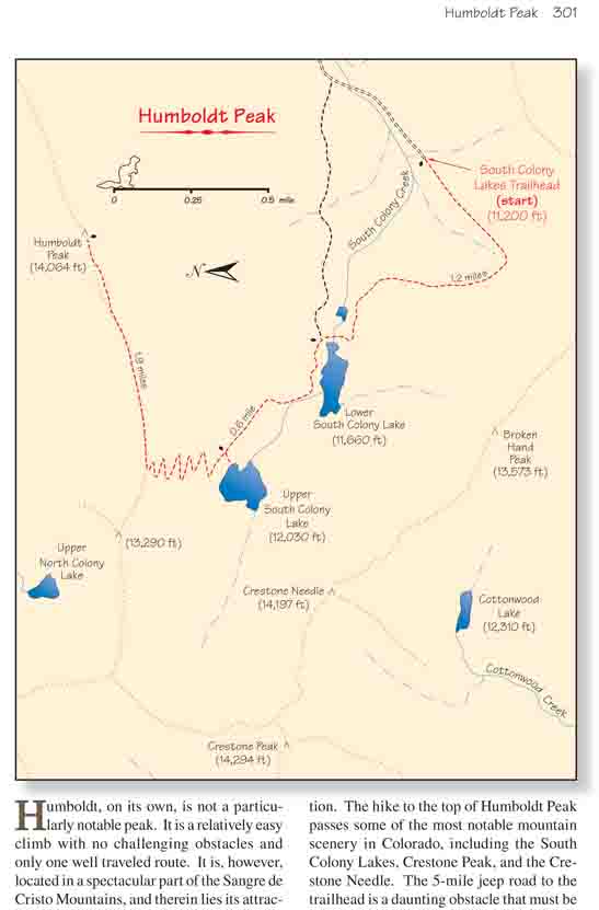
Humboldt, on its own, is not a particularly notable
peak. It is a relatively easy climb with no challenging obstacles and
only one well traveled route. It is, however, located in a spectacular
part of the Sangre de Cristo Mountains, and therein lies its attraction.
The hike to the top of Humboldt Peak passes some of the most notable
mountain scenery in Colorado, including the South Colony Lakes, Crestone
Peak, and the Crestone Needle. The 5-mile jeep road to the trailhead is
a daunting obstacle that must be surmounted before even beginning the
hike, but a surprising number of people each year are willing to endure
the grueling drive to reach the incredible basin that surrounds the
South Colony Lakes. Probably more than half of the visitors are serious
mountaineers that come for the express purpose of climbing one or both
of the Crestones. But many also climb Humboldt just for the opportunity
to study their primary goal from above. And, after all, Humboldt Peak is
one of Colorado’s fabled fourteeners. It is Colorado’s thirty-eighth
highest peak, only 133 feet lower than the Crestone Needle.
A crude jeep road continues beyond the locked gate
toward the South Colony Lakes for a distance of 0.4 mile before turning
into a foot path. From there the trail turns north as it meanders along
the slope with very little elevation gain toward the lower lake.
Humboldt Peak rises directly in front of you along this section of
trail. It seems so close it hardly looks like a 14,000-foot peak at all,
and, indeed, it is one of the easier fourteeners in Colorado. The assent
route is clearly visible from this perspective; you will be climbing
eastward along the ridge that rises up the left side of the summit.
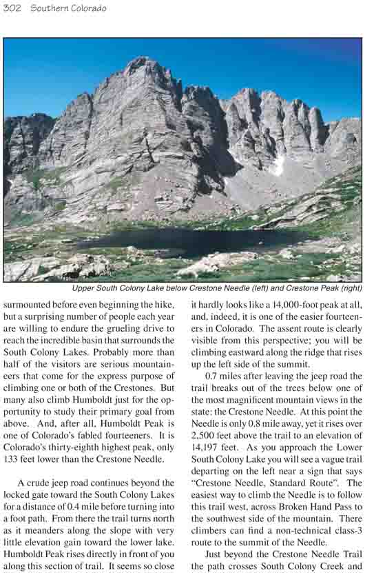
0.7 miles after leaving the jeep road the trail
breaks out of the trees below one of the most magnificent mountain views
in the state: the Crestone Needle. At this point the Needle is only 0.8
mile away, yet it rises over 2,500 feet above the trail to an elevation
of 14,197 feet. As you approach the Lower South Colony Lake you will see
a vague trail departing on the left near a sign that says "Crestone
Needle, Standard Route". The easiest way to climb the Needle is to
follow this trail west, across Broken Hand Pass to the southwest side of
the mountain. There climbers can find a non-technical class-3 route to
the summit of the Needle.
Just beyond the Crestone Needle Trail the path crosses
South Colony Creek and emerges on the eastern shore of the Lower South
Colony Lake. As you leave the lower lake you will pass an unsigned junction
where another trail departs to the east. That trail eventually ends back at
the South Colony Jeep Road about 0.4 mile below the trailhead. If you left a
vehicle at the end of the road you should take care not to get sidetracked
onto that trail on the return portion of the hike.
The trail to the upper lake continues its gradual climb
away from the lower lake, soon crossing timberline and entering the alpine
tundra that fills the upper basin. All heads will be turned to the west as
you proceed, toward the breathtaking view of Crestone Peak and the Crestone
Needle from the upper lake. A climbing route that is considered to be one of
the finest technical climbs in Colorado begins at Upper South Colony Lake
and proceeds directly up the northeast ridge, or aręte, of the Crestone
Needle. This route, rated 5.7 in difficulty, was first accomplished in 1925
by Albert Ellingwood, and it is now called the Ellingwood Aręte Route. The
entire route can clearly be seen from Upper South Colony Lake, and one
cannot help but admire those who have climbed the mountain along this highly
exposed ridge.
After leaving the upper lake the trail begins
switchbacking northward to the top of Humboldt Peak’s west ridge, finally
topping out after an elevation gain of 830 feet. Once on the crest of the
ridge the path turns east to follow it for the last 0.8 mile to the summit.
The first half of the ridge trail is easy, gaining about 900 feet over 0.5
mile. But as you approach the peak you will be challenged by a field of
sharp-edged thousand-pound boulders that you must pick your way through.
Take care not to break a leg while boulder-hopping up this part of the
climb. There is no easy way up the boulder field, but the terrain is
slightly gentler on the south side of the ridge, so try to keep on that side
as you climb. Unfortunately, this section of the trail is not well defined,
and there are many misplaced cairns that try to lure you to the north side
of the ridge. Follow only the larger monuments of stone, ignoring some of
the smaller cairns, and, arduous though it is, you will be following the
least difficult course.
Finally, after an elevation gain of 2,034 feet from Upper South Colony
Lake the route breaks out onto the west side of the summit, and from there
it is a simple walk over the last 200 yards to the mountain’s highest point.
From there you will be treated to glorious views in nearly every direction.
The North Colony Lakes are below you to the north, shadowed by Colony Baldy,
a high thirteener on the north side of North Colony Creek. Kit Carson Peak
(14,165 ft.) lies 2.7 miles west, just to the right of Crestone Peak. And,
of course, the South Colony Lakes are in full view to the south.